• Leica Disto S910 Laser Distance Meter

    Measure anything, anytime, anywhere.

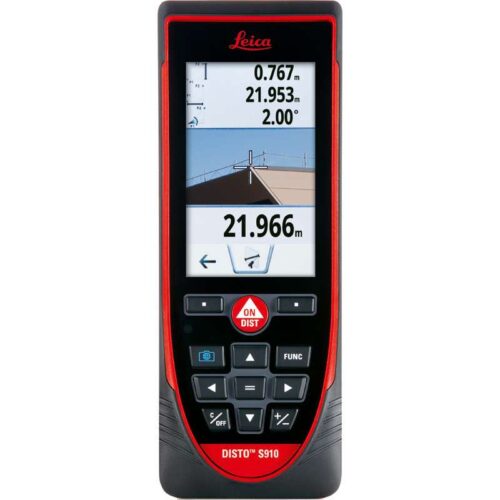
    Measure quickly and accurate distances between two points from a single location with the Leica DISTO™ S910 laser distance meter. Generate effortlessly as-built documentation, determine rooftop dimensions and integrate information into CAD or BIM software for even 3D conceptions. This improved workflows saves valued time and money. All of this at distances of up to 300 meters.

    Features include:

    • Smart Base for P2P Technology
    • Pointfinder with 4x zoom for effortless targeting
    • X-Range Power Technology for maximum measurement functioning
    • 360° tilt sensor
    • DXF data capture
    • Data transfer in real-time with WLAN
    • Bluetooth® Smart
    • Free Leica DISTO™ sketch App
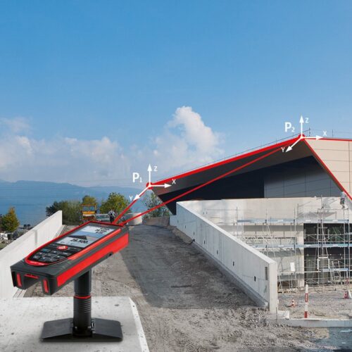
    Measure with P2P Technology The incorporated Smart Base allows distances to be measured between any two points, inclinations and angles at the same time from a single location. You will never have to reach for remote areas again, allowing even the most complicated measurement job to be carried out accurately, quickly, and safely. Attain measurement data in CAD format The Leica DISTO™ S910 laser measurer can save measured points to a DXF file as a wall layout, floor plan or 3D point coordinates which can be transferred to a PC via USB. Save money, reduce workflow and prevent mistakes. Everything is completely digital. Transfer point data in real-time Easily move measurement data promptly on site over the Wireless LAN interface to a transportable computer for additional processing in your favoured software. Produce documentation or assess lay-outs in real-time and communicate measurement points as you need with or without pictures. X-Range Power Technology The state-of-the-art X-Range Power Technology included with the Leica DISTO™ S910 represents the future of measuring technology. It successfully measures distances of up to 300 meters and guarantees the optimum measuring functioning even to badly reflecting objects.

    Includes:

    • Leica DISTO™ S910 laser distance meter
    • Smart Base Extension
    • Holster
    • Hand loop
    • USB charger incl. 4 plugs
  • Leica FlexLine TS03 Manual Total Station

    The Leica FlexLine TS03 high-quality, manual total station is based on a proven product concept that has been revolutionising the world of measurement and survey for nearly 200 years. The Leica TS03 is equipped with a comprehensive application-based software package - Leica FlexField software - that enables most survey and stakeout tasks to be carried out easily and efficiently. The new FlexLine TS03 works reliably and delivers accurate results even in the harshest environments. • Work faster: measure more points per day due to faster measurement and stakeout procedures (endless drives, trigger key, drives on both sides, pinpoint EDM and more), supported by our comprehensive and user-friendly Leica FlexField software. • Use it trouble-free: increase productivity and minimise downtime by relying on instruments that simply work and come with a global service and support network. • Choose products that are built to last: FlexLine operates with the same high level of quality even after years of use under harsh conditions (like mud, dust, blowing rain, extreme heat and cold). • Control your investment: reliability, speed and accuracy ensure a lower investment over the product lifetime and a higher resell value.
  • "Finest visibility with innovative green beam technology!

    The Lino L2G+ cross line laser from Leica Geosystems projects highly visible lines at right angles to each another. This laser makes use of the latest green laser beam technology, increasing visibility and clarity of the lines. Put simply this laser makes it easier reference line to be seen and even with this latest technology the Leica Lino will function for 7 hours on a just single set of batteries."

    The complete all in one alignment and layout device

    The Leica Lino L2P5 incorporates all of the functionality and advantages of all the Lino line and dot lasers. It features two lines and four points which are at complete right angles to each other. The Leica Lino L2P5 ensures you are ready for any levelling work.

    Advantages of the L2P5 Point Laser

    • Self-levelling functionality
    • Ergonomic and stylish housing
    • Precise 90° angles
    • Sizeable lens
    • Simple and easy to use

    Package includes:

    • Leica Lino L2P5 Line & Dot Laser
    • Target plate
    • Multifunction adapter (Magnetic)
    • 4x AA type alkaline batteries
    • Protective pouch
  • Leica LS15 Digital Level

    More comfort with exceptionally reliable results

    Complicated infrastructure demands the uppermost accuracy when defining and setting out reference heights. With dedication in striving forward, Leica Geosystems have produced the Leica LS10 & LS15 Digital Levels to provide an enjoyable field experience. From measuring roads, railways, bridges or other structures, the Leica LS Digital Levels provide reassurance and ease to an extensive range of complicated levelling applications. The Leica LS15 achieves all project steps, simplifying demanding tasks associated with the levelling process. 0.2 mm accuracy is accomplished by aiming at the target with the use of the colour touch display and pressing the measuring control. Features such as an electronic bubble, autofocus and tilt checks prior to each measurement help to reduce measuring professionals’ fatigue over a day’s work, reducing the risk of human-based errors.

    Faster staff sighting

    The Leica LS15 Digital Level is the only one on the market which is equipped with a camera and enables target staffs to be sighted quicker. Operators need to simply locate the staff on the cameras touch screen display and press the measuring button which automatically records the staff reading and measurement data.

    Precise hardware

    Automated functions and industry-leading 0.2 mm accuracy to standard Invar staffs deliver unmatched reliability. Precision begins by using the electronic level bubble to set up instruments. After one button press, automatic tilt checks are made prior to each measurement. Integrated autofocus not only finds your target faster, it increases measurement accuracy by maximising contrast of the staff.

    Infinitely bridging field to office

    The field experience of Leica LS digital levels does not finish in the field. After easily transferring your data to the office via a USB or Bluetooth®, Leica Infinity processes your results hassle-free back in the office. This intuitive software enables easy-tounderstand displays of complex levelling data. Combine tables with graphics or even cross check project data in one window for one overall view of level lines, line calculations or adjustments.

    Highest Accuracy

    • 0.2 mm accuracy even with standard Invar staffs
    • Electronic level bubble for perfect instrument setup
    • Tilt check prior to each measurement
    • Autofocus for maximal contrast of staff

    Efficiency of Work

    • Digital camera enables fast and accurate staff sighting
    • Streamline levelling processes with just one push of a button
    • Fast and easy data transfer using USB and Bluetooth® connectivity

    Field Experience

    • Visualisation of level lines in the field and in the office
    • Screenshots document site and field results
    • Step-by-step display guidance for levelling line flows
  • Leica NA720 Automatic Level

    The Leica NA720 automatic level is extremely popular within the construction industry being known for its increased robustness and precision when working in tough environments. Onsite hazards such as falling to ground from a low height, exposure to water and vibrations caused by heavy machinery are no problem for the robust Leica NA720. With no need to re-adjust this level carries on working and measuring precisely, day in and day out. The horizontal circle and circular bubble are easily read, both being positioned next to the telescope and the external sight allowing for easy targeting. The upright image is clearly shown and the double sided endless drives provide fast targeting. The NA720 comes with one of the finest optics allowing for short measuring distances, measuring in adverse light conditions and accurate aiming. The increased tough and robust features of the NA720 include waterproof and protection against dust. The tight seals and gas filled telescope give protection against hazards should the instrument be dropped in to water.

    Leica NA720 features include:

    • 20x magnification
    • Upright telescope image
    • Gas filled telescope
    • 30mm objective diameter
    • 50cm short focus distance
    • 360 degree / 400 gon selectable angle measurement
    • 10’ / 2 mm circular bubble
    • Endless Horizontal Drive
    • 2.5mm double run accuracy
    • ± 15’ working range
    • Water resistant
    • –20 to +50 °C operating temperature
    • 1.6kg total weight
    • 19cm x 12cm x 12cm

    Includes:

    • Leica NA720 Automatic Level
    • Carry Case
    • User Manual
  • Leica Geosystems Rugby 270 SG Construction Laser is a fully automatic, single grade laser for the general construction contractor that needs a level or single slope for flat work, site preparation, septic installation, trenching and more. This Leica Geosystems instrument is a highly accurate, general construction laser with single grade capability.

Title

Go to Top