Leica GS11 GNSS smart antenna

Contact Details

The Leica GS11 GNSS smart antenna combines reliable GNSS positioning, tilt compensation and Leica X-PAD software for efficient surveying and stakeout. Designed for everyday fieldwork, it features dual hot-swappable batteries for fewer interruptions.

The GS11 I variant adds visual surveying, augmented reality (AR) stakeout guidance and image-based measurements for hard-to-reach points.

Enquire with SITML for Leica GS11 solutions in Saudi Arabia.

Visual Surveying Meets Reliable GNSS Performance

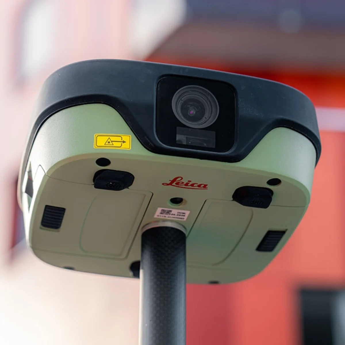
Leica GS11 GNSS smart antenna mounted on a surveying pole, showing its integrated camera at an outdoor site.

The Leica GS11 GNSS smart antenna combines trusted Leica Geosystems positioning technology with intuitive field surveying workflows. Integrated with Leica X-PAD software, it supports efficient GNSS measurements and stakeout, while the GS11 I variant adds augmented reality (AR) guidance and image-based measurements. Designed for everyday surveying applications, the GS11 helps professionals work efficiently, visualize site information and verify measurements with greater confidence before leaving the field.

Keep Moving with Reliable GNSS Performance

The Leica GS11 combines reliable GNSS positioning, tilt compensation and dual hot-swappable batteries to support efficient field surveying. Measure points with greater flexibility, reduce interruptions and maintain productivity throughout the working day.

Surveyor using the Leica GS11 GNSS smart antenna on a surveying pole for outdoor stakeout measurements.

Stake Out with Clarity and Confidence

The Leica GS11 I combines live camera imagery with augmented reality (AR) guidance through Leica X-PAD software, displaying stakeout information directly within the real-world site view. This visual surveying workflow helps surveyors locate target points more intuitively, improve positioning clarity and complete field stakeout tasks efficiently.

Powered by Leica X-PAD Field Software

Leica X-PAD connects the GS11 GNSS smart antenna with intuitive field workflows for GNSS measurements, stakeout and on-site verification. With the GS11 I, camera-assisted visual surveying adds real-world guidance, helping surveyors locate points, interpret site information and verify measurements efficiently.

Measure Beyond Reach with Leica GS11

The Leica GS11 GNSS smart antenna helps surveyors capture difficult-to-access points with greater flexibility. Tilt compensation supports measurements using a tilted pole, while the GS11 I adds image-based and integrated laser measurement capabilities for obstructed or hard-to-reach locations.

Surveyor carrying a Leica GS11 GNSS smart antenna and field controller along a fenced surveying site.

Verify Measurements Before Leaving the Site

Review surveyed points with Leica X-PAD and use the Leica GS11 I visual surveying capabilities for augmented reality (AR) quality checks. Verify GNSS measurements against real site conditions, identify missing points and confirm survey completeness before leaving the field, reducing the need for return visits.

Surveyor holding a pole-mounted Leica GS11 GNSS smart antenna outdoors during professional field surveying.

Trusted Leica GNSS Performance

The Leica GS11 combines dependable GNSS positioning with intuitive Leica X-PAD field workflows and the backing of Leica Geosystems’ global support network. Built for professional surveying applications, it delivers reliable performance with access to local product guidance and support through SITML in Saudi Arabia.

The visual surveying workflow

Receive and Prepare Survey Data

Prepare your GNSS surveying tasks with Leica X-PAD by importing project data, coordinate systems and CAD drawings. Connect the Leica GS11, organize measurement and stakeout points, and prepare site maps for an efficient field surveying workflow.

Measure and Stake Out Survey Points

Capture GNSS survey points and perform precise stakeout tasks with the Leica GS11 and its tilt compensation capabilities. The GS11 extends measurement flexibility through image-based measurements and an integrated laser, helping surveyors capture difficult-to-reach points efficiently.

Illustration of connected survey measurement points with a checkmark, representing Leica GS11 field verification and reporting.

Verify and Report Survey Results

Review GNSS measurements in real time using Leica X-PAD, with augmented reality (AR) visual validation available on the Leica GS11. Generate image-based survey reports, confirm measurement accuracy and check project completeness on-site to help minimize return visits.

Illustration of a document with connected survey data points representing Leica GS11 GNSS measurement processing and reporting.

Process and Deliver Survey Data

Sync field data through Hexagon GeoCloud and use Leica X-PAD Fusion to process Leica GS11 GNSS measurements, prepare survey drawings and generate project reports. This connected workflow helps surveying professionals organize field results and deliver accurate project documentation efficiently.

Why choose the Leica GS11?

Frequently Asked Questions

The Leica GS11 is available in different variants to suit your surveying and stakeout needs. The GS11 I features dual cameras and supports visual surveying with Leica X-PAD field software, including overlaying measured points or design data on the live camera view, measuring points from images and staking out with live AR guidance. It also features tilt compensation and laser measurement. The GS11 T offers tilt compensation for fast, efficient point measurement without levelling the pole, but does not include imaging capabilities.
Additional configurations are available. View the GS11 data sheet for details on available variants and specifications

Visual survey uses the Leica GS11’s dual cameras to display collected data overlaid on a live AR view. This enables you to check what you’ve measured with live site context. Powered by Leica X-PAD, visual surveying extends how you can interact with and validate your data directly in the field while maintaining the trusted accuracy of Leica GNSS.

Visual stakeout combines the Leica GS11’s dual cameras with Leica X-PAD to overlay stakeout guidance onto live camera imagery. Instead of navigating using distances alone, you can see exactly where to move in real-world context, making stakeout faster, more intuitive, and easier to understand, especially in complex environments.

The integrated laser extends the range of points you can measure when placing the pole tip isn’t practical. Together with image-based measurements and tilt compensation, it gives you multiple ways to capture points in difficult or hard-to-reach locations, helping you work more safely and efficiently in the field.

Yes. The Leica GS11 features dual hot-swappable batteries, allowing you to replace a battery without powering down the smart antenna. This helps minimise interruptions, keeps your measurements running, and supports continuous productivity throughout the working day.

The Leica GS11 is designed to work with  Leica X-PAD, unlocking visual surveying, visual stakeout, image-based measurements, and streamlined GNSS workflows. X-PAD also gives you the flexibility to work on your preferred Android tablet or smartphone, or on the rugged Leica CSX8 field tablet, so you can choose the device that best suits your way of working.

Leica Geosystems

Leica Geosystems Saudi Arabia – Precision Meets Innovation

Introduction

Leica Geosystems Saudi Arabia delivers unmatched precision, durability, and advanced geospatial performance for professionals across construction, infrastructure, mining, and agriculture. For over 200 years, Leica has pioneered surveying instruments, GNSS/GPS systems, laser scanners, and software platforms that empower projects worldwide.

Trusted Worldwide, Available Locally in Saudi Arabia

Founded in Switzerland, Leica Geosystems has built a legacy of engineering excellence. Now available in Saudi Arabia through authorized dealers, Leica Geosystems Saudi Arabia products are adapted for the region’s challenging environments—providing local support, training, and calibrated precision.

Innovation in Every Leica Geosystems Product

Ranging from sophisticated total stations and GNSS receivers to mobile mapping and high-definition laser scanners, Leica Geosystems Saudi Arabia offers real-time accuracy and seamless digital workflows that boost project efficiency and reduce field downtime.

Key Achievements & Milestones

  • Over 200 years of geomatics innovation

  • Inventor of the world’s first digital level and early laser distance meters

  • Reality capture systems deployed in 100+ countries

  • Trusted in major infrastructure, metro, and oil & gas surveying

  • Adopted by engineers, surveyors, and government agencies worldwide

Why Choose Leica Geosystems in Saudi Arabia?

  • Localized support: Technical assistance, training, and product availability through authorized dealers

  • Unmatched accuracy: Instruments deliver centimeter-level precision and durability

  • Comprehensive portfolio: Full range from DISTO distance meters to robotic total stations and reality capture systems

  • Smart integration: Compatible with Hexagon, Autodesk, and other industry-leading software platforms

Leica Product Range in KSA

Leica Cyclone Software Portfolio

  • Cyclone REGISTER 360 PLUS – Guided workflows to register and visualize point cloud datasets with automation for efficient office workflows

  • Cyclone 3DR – End-to-end solution to analyze and model point clouds into actionable 3D deliverables

  • Cyclone Enterprise – On‑premise project and data management platform for centralized reality capture workflows

  • Cyclone Cloud – Subscription-based SaaS portal offering centralized license management and secure cloud-hosted service access

Get in Touch - Contact Us

Discover how Leica Geosystems Saudi Arabia solutions can elevate your next project. Reach out to your authorized local distributor to request demos, pricing, and expert consultation tailored to your requirements.

Official Website: www.leica-geosystems.com
Leica Geosystems new red logo featuring the updated Leica wordmark on a black background

Leica Geosystems is a world leader in precision surveying and geospatial solutions with over 200 years of expertise. From total stations and GNSS/GPS receivers to 3D laser scanning systems, Leica products deliver exceptional accuracy and reliability for construction, infrastructure, and mapping projects in Saudi Arabia and worldwide.

Go to Top