Leica NAK2 Automatic Level

Contact Details

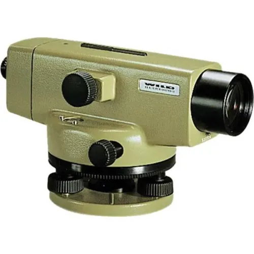
The NAK2 automatic level is the flagship optical level product from Leica Geosystems. Designed by leading surveyors and developed by highly skilled engineers with a great deal of experience in knowing what an instrument must achieve in the field. Created for all types of surveying task. the NAK2 is economical and productive for routine levelling task on building sites, for geodetic control at all levels of accuracy, and in engineering projects.

Features of the NAK2

  • Suited for levelling of all orders and types of accuracy
  • Accurate settlement and levelling determinations
  • Routine heighting for road, railway, pipeline, and tunnel construction
  • Control measurements and setting-out work on site
  • High accuracy area levelling
  • K-version on flat terrain provides Tacheometric levelling by bringing together stadia and angular measurements with height readings
  • Bridge monitoring and deformation measurement


The NAK2 provides added angle measurement.

The model NAK2 has an internal glass circle which is read via a scale microscope and which can be set to any value by turning the rim around the base of the instrument. Tacheometric levelling is also available with the K-version on fl at terrain by combining stadia and angular measurements with height readings.

Generally, the NAK2 is able to set up on any Leica tripod. In most cases we recommend the heavy-duty Leica GST20 Wooden Tripod. For precise levelling the GST40 Wooden Tripod is suitable due to its extreme rigidity.

The durable and tough NAK2 can be used in varying weather conditions and very reliable when used in harsh working conditions such as the building site. The pendulum compensator is protected against shocks and the vibration damping mechanism is highly effective.

Set up is quick and easy with the circular level only needing to be centred approximately and bring the compensator into its working range. The Pentaprism provides a positive bubble which is monitored down the eyepiece.

The high quality optics within the telescope provides bright, high contrast images which can be focussed on quickly.

For ease of use and the press of one button, the instantaneous check facility give complete confidence. Controls are well designed and arranged for added convenience and the endless horizontal drive enables rapid fine pointing.

Accessories including the parallel-plate, laser eyepiece, increase the potential use of this impressive levelling instrument.

SKU: 2801170 Category:

Description

NA2 NAK2
Magnification 32x 32x
Gas Filled Telescope Yes Yes
Angle Measurement 360° 360°
Multiplication factor/additive constant 100/0 100/0
Accuracy standard deviation per km double run up to 0.7 mm up to 0.7 mm
Dust/water IP53 IP53
Working temperature -20°C
+50°C
-20°C
+50°C
Storage temperature -40°C
+70°C
-40°C
+70°C
Dimensions 25x25x-
12cm
25x25x-
12cm
Weight 2.4kg 2.4kg

Brand

Leica Geosystems

Leica Geosystems Saudi Arabia – Precision Meets Innovation

Introduction

Leica Geosystems Saudi Arabia delivers unmatched precision, durability, and advanced geospatial performance for professionals across construction, infrastructure, mining, and agriculture. For over 200 years, Leica has pioneered surveying instruments, GNSS/GPS systems, laser scanners, and software platforms that empower projects worldwide.

Trusted Worldwide, Available Locally in Saudi Arabia

Founded in Switzerland, Leica Geosystems has built a legacy of engineering excellence. Now available in Saudi Arabia through authorized dealers, Leica Geosystems Saudi Arabia products are adapted for the region’s challenging environments—providing local support, training, and calibrated precision.

Innovation in Every Leica Geosystems Product

Ranging from sophisticated total stations and GNSS receivers to mobile mapping and high-definition laser scanners, Leica Geosystems Saudi Arabia offers real-time accuracy and seamless digital workflows that boost project efficiency and reduce field downtime.

Key Achievements & Milestones

  • Over 200 years of geomatics innovation

  • Inventor of the world’s first digital level and early laser distance meters

  • Reality capture systems deployed in 100+ countries

  • Trusted in major infrastructure, metro, and oil & gas surveying

  • Adopted by engineers, surveyors, and government agencies worldwide

Why Choose Leica Geosystems in Saudi Arabia?

  • Localized support: Technical assistance, training, and product availability through authorized dealers

  • Unmatched accuracy: Instruments deliver centimeter-level precision and durability

  • Comprehensive portfolio: Full range from DISTO distance meters to robotic total stations and reality capture systems

  • Smart integration: Compatible with Hexagon, Autodesk, and other industry-leading software platforms

Leica Product Range in KSA

  • Total Stations – Manual and robotic total stations for construction and high-precision surveying.

  • Mobile Mapping Systems – Pegasus TRK Neo, Pegasus:Backpack, BLK2GO for vehicle, wearable, and handheld 3D capture

  • GPS & GNSS Equipment – GS18 I GNSS RTK rover, iCON GPS smart antennas offering tilt-compensated precision positioning

  • Ground Penetrating Radar (GPR) – Leica GPR solutions for accurate subsurface mapping

  • Laser Scanners – ScanStation P‑Series, RTC360, BLK360, and BLK2FLY for HD 3D scanning and digital twin workflows

  • DISTO Laser Distance Meters & Levels – Leica DISTO™ meter series and LINO/Rugby laser levels for point‑to‑point measurements and leveling

Leica Cyclone Software Portfolio

  • Cyclone REGISTER 360 PLUS – Guided workflows to register and visualize point cloud datasets with automation for efficient office workflows

  • Cyclone 3DR – End-to-end solution to analyze and model point clouds into actionable 3D deliverables

  • Cyclone Enterprise – On‑premise project and data management platform for centralized reality capture workflows

  • Cyclone Cloud – Subscription-based SaaS portal offering centralized license management and secure cloud-hosted service access

Get in Touch - Contact Us

Discover how Leica Geosystems Saudi Arabia solutions can elevate your next project. Reach out to your authorized local distributor to request demos, pricing, and expert consultation tailored to your requirements.

Official Website: www.leica-geosystems.com

Leica Geosystems is a world leader in precision surveying and geospatial solutions with over 200 years of expertise. From total stations and GNSS/GPS receivers to 3D laser scanning systems, Leica products deliver exceptional accuracy and reliability for construction, infrastructure, and mapping projects in Saudi Arabia and worldwide.

Reviews

There are no reviews yet.

Only logged in customers who have purchased this product may leave a review.

Title

Go to Top