Leica Pegasus TRK EVO

Contact Details

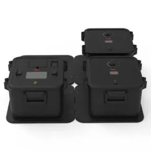
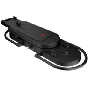
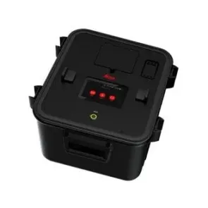
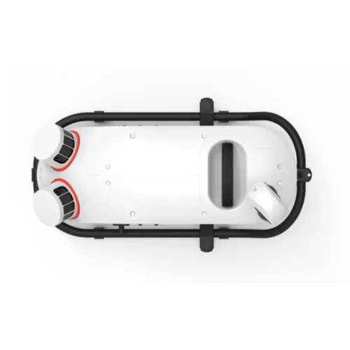
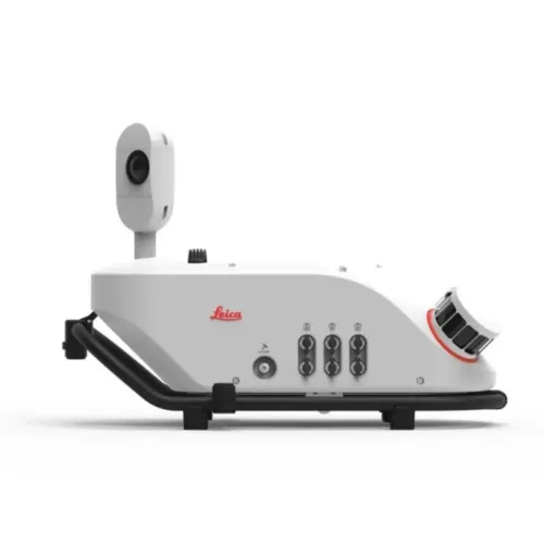
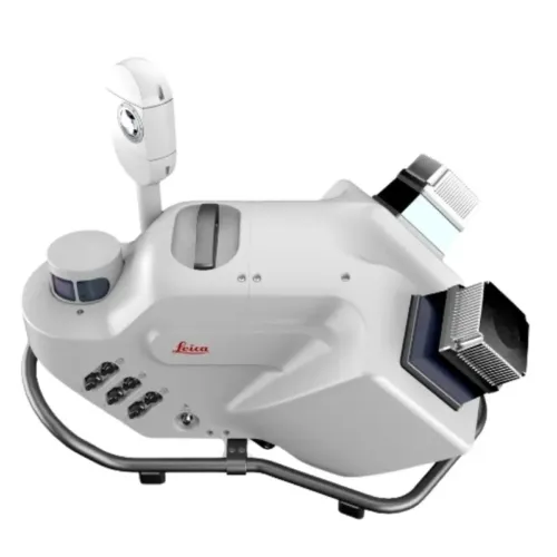
The Leica Pegasus TRK EVO is a lightweight, AI-enhanced mobile mapping system for capturing geospatial data at scale. Designed for vehicle-mounted 3D reality capture with survey-grade accu

The Leica Pegasus TRK EVO is a next-generation mobile mapping system engineered for intelligent, large-scale geospatial data collection. Mounted on a vehicle, it captures detailed 3D point clouds, high-resolution imagery, and GNSS-referenced data in a single, integrated workflow.

With advanced AI capabilities, automated object recognition, and cloud-based processing, the TRK EVO transforms how surveying and mapping professionals manage large infrastructure, roads, rail, and smart city projects in Saudi Arabia. Its lightweight design and one-person operation make it ideal for rapid deployment across urban and remote environments.

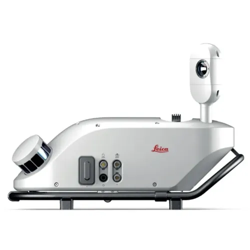
Compatible with the Leica Pegasus software suite, the TRK EVO ensures seamless data integration, visualization, and analysis. Backed by SITML, your authorized Leica Geosystems distributor and mobile mapping service partner in KSA.

cy across Saudi Arabia’s infrastructure and road networks.


SKU: Leica Pegasus TRK EVO Category:

Description

Precision Mobile Mapping System for Survey-Grade, High-Detail Data Capture

The Leica Pegasus TRK Evo is purpose-built for applications where maximum accuracy and intricate detail are essential. Leveraging industry-leading scanner precision and exceptional point cloud density, it captures fine surface textures, making it the ideal tool for complex infrastructure inspections and engineering-grade workflows.

Available in both Pegasus TRK500 (single-head) and TRK700 (dual-head) configurations, the TRK Evo delivers up to 4.4 million points per second, enabling the collection of ultra-dense geospatial datasets with minimal effort. Its streamlined mounting system and fast deployment design allow for efficient operation by a single user in the field.

Integrated with Leica Pegasus FIELD and Pegasus OFFICE, the TRK Evo supports an optimized workflow from capture to output. With built-in RTK processing, users can process and export data on-site, minimizing delays and boosting productivity. Additionally, real-time anonymization ensures that privacy and regulatory compliance are maintained automatically. A rugged hardware design ensures consistent performance in demanding or harsh environments.

Optimized for high-accuracy, survey-grade mapping, the Pegasus TRK Evo delivers unmatched quality for professionals who require uncompromising precision and efficiency in every dataset.

Leica Pegasus TRK500 Evo

The TRK500 Evo is a single-head, data-efficient mobile mapping system capable of capturing up to 2 million points per second using a precise single-line scanning pattern—ideal for comprehensive, high-resolution mapping tasks.

Leica Pegasus TRK700 Evo

Featuring a dual-scanner configuration, the TRK700 Evo captures up to 4 million points per second in a crossed-line pattern. This setup delivers high-density point clouds with enhanced detail, making it perfect for complex infrastructure projects and advanced geospatial applications.

Discover the Leica Pegasus TRK Neo Mobile Mapping System

Real-world applications

Engineering Applications

The Pegasus TRK Evo provides precise geospatial data to support construction and infrastructure design, helping ensure accuracy throughout planning, execution, and long-term project lifecycle management.

Rail Infrastructure Surveys

Engineered for high-accuracy mobile mapping, the Pegasus TRK Evo delivers detailed insights for railway infrastructure, supporting maintenance planning, safety inspections, and upgrade or renewal strategies.

Detailed Structural Analysis

The Pegasus TRK Evo captures high-resolution geospatial data, enabling the evaluation of tunnels, viaducts, and other complex structures to assess structural health, safety, and inform future planning decisions.

Road Infrastructure Surveys

Ideal for road engineering projects, the Pegasus TRK Evo delivers accurate data for pre-construction assessments, progress tracking, and pavement condition analysis, supporting effective maintenance and infrastructure planning.

Brand

Leica Geosystems

Leica Geosystems Saudi Arabia – Precision Meets Innovation

Introduction

Leica Geosystems Saudi Arabia delivers unmatched precision, durability, and advanced geospatial performance for professionals across construction, infrastructure, mining, and agriculture. For over 200 years, Leica has pioneered surveying instruments, GNSS/GPS systems, laser scanners, and software platforms that empower projects worldwide.

Trusted Worldwide, Available Locally in Saudi Arabia

Founded in Switzerland, Leica Geosystems has built a legacy of engineering excellence. Now available in Saudi Arabia through authorized dealers, Leica Geosystems Saudi Arabia products are adapted for the region’s challenging environments—providing local support, training, and calibrated precision.

Innovation in Every Leica Geosystems Product

Ranging from sophisticated total stations and GNSS receivers to mobile mapping and high-definition laser scanners, Leica Geosystems Saudi Arabia offers real-time accuracy and seamless digital workflows that boost project efficiency and reduce field downtime.

Key Achievements & Milestones

  • Over 200 years of geomatics innovation

  • Inventor of the world’s first digital level and early laser distance meters

  • Reality capture systems deployed in 100+ countries

  • Trusted in major infrastructure, metro, and oil & gas surveying

  • Adopted by engineers, surveyors, and government agencies worldwide

Why Choose Leica Geosystems in Saudi Arabia?

  • Localized support: Technical assistance, training, and product availability through authorized dealers

  • Unmatched accuracy: Instruments deliver centimeter-level precision and durability

  • Comprehensive portfolio: Full range from DISTO distance meters to robotic total stations and reality capture systems

  • Smart integration: Compatible with Hexagon, Autodesk, and other industry-leading software platforms

Leica Product Range in KSA

  • Total Stations – Manual and robotic total stations for construction and high-precision surveying.

  • Mobile Mapping Systems – Pegasus TRK Neo, Pegasus:Backpack, BLK2GO for vehicle, wearable, and handheld 3D capture

  • GPS & GNSS Equipment – GS18 I GNSS RTK rover, iCON GPS smart antennas offering tilt-compensated precision positioning

  • Ground Penetrating Radar (GPR) – Leica GPR solutions for accurate subsurface mapping

  • Laser Scanners – ScanStation P‑Series, RTC360, BLK360, and BLK2FLY for HD 3D scanning and digital twin workflows

  • DISTO Laser Distance Meters & Levels – Leica DISTO™ meter series and LINO/Rugby laser levels for point‑to‑point measurements and leveling

Leica Cyclone Software Portfolio

  • Cyclone REGISTER 360 PLUS – Guided workflows to register and visualize point cloud datasets with automation for efficient office workflows

  • Cyclone 3DR – End-to-end solution to analyze and model point clouds into actionable 3D deliverables

  • Cyclone Enterprise – On‑premise project and data management platform for centralized reality capture workflows

  • Cyclone Cloud – Subscription-based SaaS portal offering centralized license management and secure cloud-hosted service access

Get in Touch - Contact Us

Discover how Leica Geosystems Saudi Arabia solutions can elevate your next project. Reach out to your authorized local distributor to request demos, pricing, and expert consultation tailored to your requirements.

Official Website: www.leica-geosystems.com

Leica Geosystems is a world leader in precision surveying and geospatial solutions with over 200 years of expertise. From total stations and GNSS/GPS receivers to 3D laser scanning systems, Leica products deliver exceptional accuracy and reliability for construction, infrastructure, and mapping projects in Saudi Arabia and worldwide.

Reviews

There are no reviews yet.

Only logged in customers who have purchased this product may leave a review.

Title

Go to Top