Leica RTC360 Laser Scanner

Contact Details

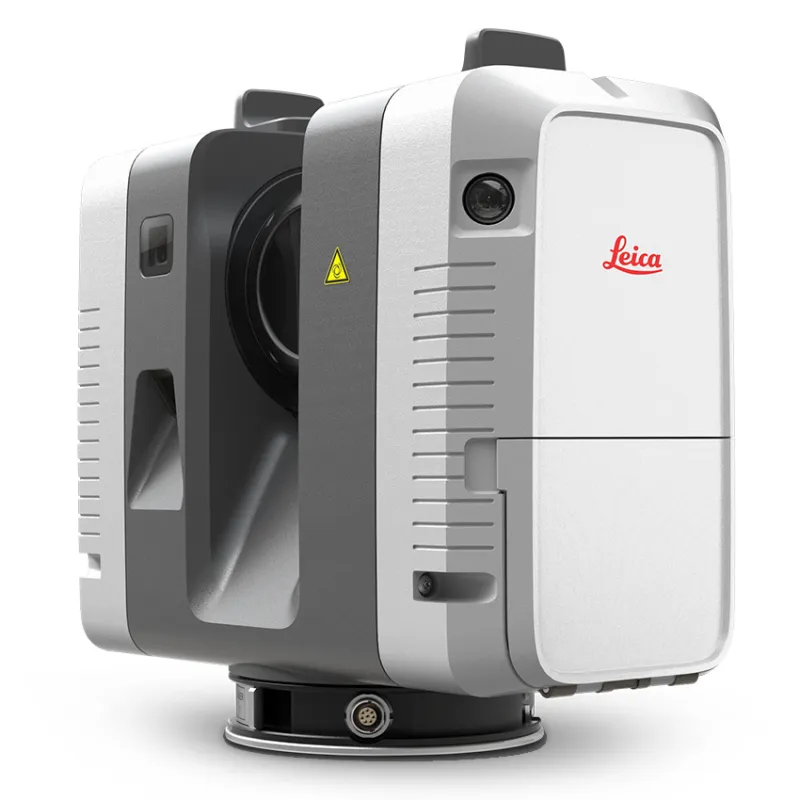
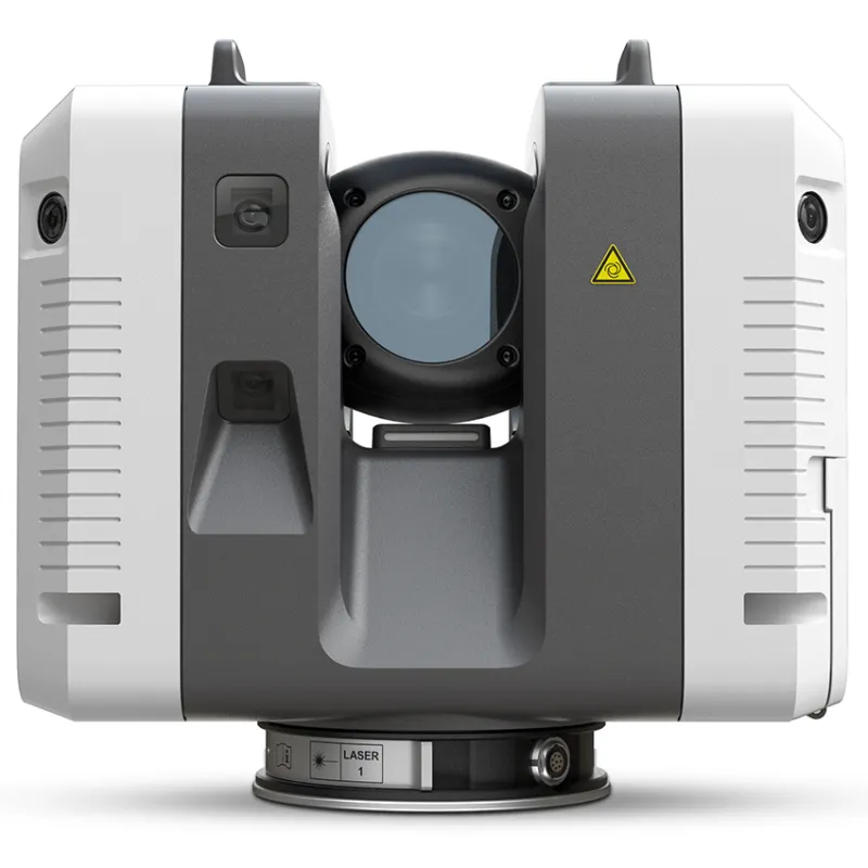
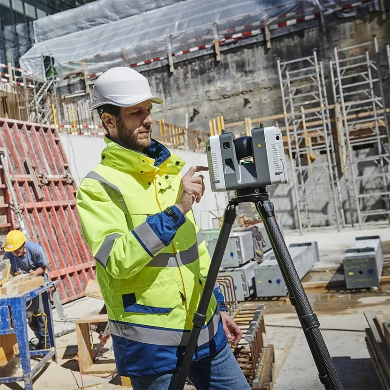
Fast, agile and precise 3D reality capture solution

FAST

The Leica RTC360 laser scanner makes 3D reality capture faster than ever before. With a measuring rate of up to 2 million points per second and advanced HDR imaging system, the creation of colored 3D point clouds can be completed in under 2 minutes. Plus, automated targetless field registration (based on VIS technology) and the seamless, automated transfer of data from site to office reduce time spent in the field and further maximize productivity.

Agile

Small and lightweight, the Leica RTC360 scanner’s portable design and collapsible tripod mean it’s compact enough to fit into most backpacks, ready to be taken anywhere. Once on-site, easy-to-use one-button operation makes for fast, hassle-free scanning.

Precise

Low noise data allows for better images, resulting in crisp, high-quality scans that are rich in detail and ready for use in a range of applications. Combined with Cyclone FIELD 360 software for automated registration in the field, the Leica RTC360 scanner offers outstanding precision that can be checked on-site.

SKU: LeicaRTC360 Category:

Description

Kit includes

  • Leica RTC360 Laser Scanner
  • Transport Container
  • GEB361 Lithium-Ion Battery
  • GKL341 Multichanger Prof 5000
  • 256gb USB Flash Drive
  • Rain Cover
  • System USB Card
  • GST80 Lightweight Tripod
  • GVP730 Backpack
  • GAD121 Tribrach Adapter
  • GAD122 Adapter
  • RTC360 Quick Guide
  • 1 Year Basic CCP
Leica RTC360 Product Specifications
3D Laser Scanner High-speed 3D laser scanner with integrated HDR spherical imaging system and Visual Inertial System (VIS) for real time registration
Data acquisition < 2 min for complete full dome scan and spherical HDR image at 6mm @ 10m resolution
Real time registration Automatic point cloud alignment based on real time tracking of scanner movement between setups based on Visual Inertial System (VIS) by video-enhanced inertial measurement unit
Double scan Automatic removal of moving objects
Distance measurement High-speed, high dynamic time of flight enhanced by Waveform Digitizing (WFD) technology
Laser Class 1 (in accordance with IEC 60825-1:2014), 1550nm (invisible)
Field of view 360° (horizontal) / 300° (vertical)
Range Min. 0.5 - up to 130 m
Speed Up to 2‘000‘000 pts / sec
Resolution 3 user selectable settings (3/6/12mm @ 10m)
Accuracy Angular accuracy 18”
Range accuracy 1.0 mm + 10 ppm
3D point accuracy
1.9 mm @ 10 m
2.9 mm @ 20 m
5.3 mm @ 40 m
Range noise 0.4 mm @ 10 m, 0.5 mm @ 20 m
Camera 36 MP 3-camera system captures
432 MPx raw data for calibrated
360° x 300° spherical image
Speed 1 minute for full spherical HDR image at any light condition
HDR Automatic, 5 brackets
Visual Inertial System Video enhanced inertial measuring system to track movement of the scanner position relative to the previous setup in real time
Tilt IMU based, Accuracy: 3‘ for any tilt
Additional sensors Altimeter, Compass, GNSS
On scanner Touch-screen control with finger touch, full color WVGA graphic display 480 x 800 pixels
Mobile devices Leica Cyclone FIELD 360 app for iPad or Android tablets including:
- Remote control of scan functions
- 2D & 3D data viewing
- Tagging
- Automatic alignment of scans
Wireless Integrated wireless LAN (802.11 b/g/n)
Data storage Leica MS256, 256GB exchangeable USB 3.0 flash drive
Housing Aluminium frame and sidecovers
Dimensions 120mm x 240mm x 230mm / 4.7‘‘ x 9.4‘‘ x 9.1
Weight 5.35 kg / 11.7 lbs, nominal (w/o batteries)
Mounting mechanism Quick mounting on 5/8“ stub on lightweight tripod / optional tribrach adapter / survey tribrach adapter available
Internal battery 2 x Leica GEB361 internal, rechargeable Li-Ion batteries.
Duration: Typically up to 4 hours
Weight: 340 g per battery
External Leica GEV282 AC adapter
Operating temperature 5° to +40° C
Storage temperature 40° to +70° C
Dust/Humidity Solid particle/liquid ingress protection IP54

Brand

Leica Geosystems

Leica Geosystems Saudi Arabia – Precision Meets Innovation

Introduction

Leica Geosystems Saudi Arabia delivers unmatched precision, durability, and advanced geospatial performance for professionals across construction, infrastructure, mining, and agriculture. For over 200 years, Leica has pioneered surveying instruments, GNSS/GPS systems, laser scanners, and software platforms that empower projects worldwide.

Trusted Worldwide, Available Locally in Saudi Arabia

Founded in Switzerland, Leica Geosystems has built a legacy of engineering excellence. Now available in Saudi Arabia through authorized dealers, Leica Geosystems Saudi Arabia products are adapted for the region’s challenging environments—providing local support, training, and calibrated precision.

Innovation in Every Leica Geosystems Product

Ranging from sophisticated total stations and GNSS receivers to mobile mapping and high-definition laser scanners, Leica Geosystems Saudi Arabia offers real-time accuracy and seamless digital workflows that boost project efficiency and reduce field downtime.

Key Achievements & Milestones

  • Over 200 years of geomatics innovation

  • Inventor of the world’s first digital level and early laser distance meters

  • Reality capture systems deployed in 100+ countries

  • Trusted in major infrastructure, metro, and oil & gas surveying

  • Adopted by engineers, surveyors, and government agencies worldwide

Why Choose Leica Geosystems in Saudi Arabia?

  • Localized support: Technical assistance, training, and product availability through authorized dealers

  • Unmatched accuracy: Instruments deliver centimeter-level precision and durability

  • Comprehensive portfolio: Full range from DISTO distance meters to robotic total stations and reality capture systems

  • Smart integration: Compatible with Hexagon, Autodesk, and other industry-leading software platforms

Leica Product Range in KSA

  • Total Stations – Manual and robotic total stations for construction and high-precision surveying.

  • Mobile Mapping Systems – Pegasus TRK Neo, Pegasus:Backpack, BLK2GO for vehicle, wearable, and handheld 3D capture

  • GPS & GNSS Equipment – GS18 I GNSS RTK rover, iCON GPS smart antennas offering tilt-compensated precision positioning

  • Ground Penetrating Radar (GPR) – Leica GPR solutions for accurate subsurface mapping

  • Laser Scanners – ScanStation P‑Series, RTC360, BLK360, and BLK2FLY for HD 3D scanning and digital twin workflows

  • DISTO Laser Distance Meters & Levels – Leica DISTO™ meter series and LINO/Rugby laser levels for point‑to‑point measurements and leveling

Leica Cyclone Software Portfolio

  • Cyclone REGISTER 360 PLUS – Guided workflows to register and visualize point cloud datasets with automation for efficient office workflows

  • Cyclone 3DR – End-to-end solution to analyze and model point clouds into actionable 3D deliverables

  • Cyclone Enterprise – On‑premise project and data management platform for centralized reality capture workflows

  • Cyclone Cloud – Subscription-based SaaS portal offering centralized license management and secure cloud-hosted service access

Get in Touch - Contact Us

Discover how Leica Geosystems Saudi Arabia solutions can elevate your next project. Reach out to your authorized local distributor to request demos, pricing, and expert consultation tailored to your requirements.

Official Website: www.leica-geosystems.com

Leica Geosystems is a world leader in precision surveying and geospatial solutions with over 200 years of expertise. From total stations and GNSS/GPS receivers to 3D laser scanning systems, Leica products deliver exceptional accuracy and reliability for construction, infrastructure, and mapping projects in Saudi Arabia and worldwide.

Reviews

There are no reviews yet.

Only logged in customers who have purchased this product may leave a review.

Title

Go to Top