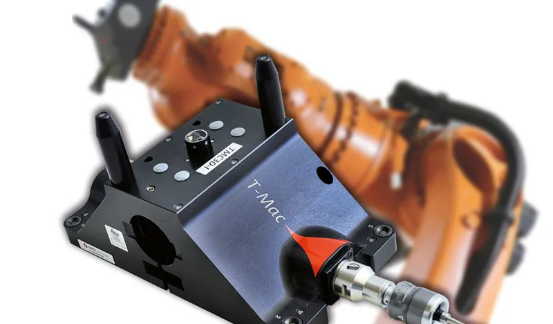
Leica T-Mac (Tracker-Machine control sensor), the next-generation 6DoF tracking device for automated applications, answers the needs of a growing number of Leica Geosystems customers who have either modified the existing Leica T-Probe for automated measurement applications or have expressed interest in doing so.
Leica T-Mac is an off-the-shelf solution that can be custom-tailored to the needs of a specific application. For example, when needed, an interface for precise tool exchange units can be included.
Leica Absolute Tracker AT960 7DoF Explained
Sensing-Thinking-Acting – The 7DoF-feature of the Leica Absolute Tracker AT960. Experience real-time correction of automated large-volume manufacturing applications using laser tracker technology.
Operating specifications and accuracy information, including the maximum range of 30 m (98 ft) correspond to those of Leica T-Probe.
PowerLock: For the first time in the history of laser trackers, the laser beam moves to the user, not the other way around.
Special housing for easy installation on machines or robots
Additional reflector nests for calibration and easy orientation
Mechanical interface to calibration tool
Interface for precise tool exchange unit
Largest operation measurement volume of up to 30 m (98 ft)
Wider acceptance angle than any comparable system: pitch ±45°, yaw ±45°, roll 360°
Visual feedback for power on, in-view and in-distance status and for process information
Acoustic process information feedback
Insensitive to environmental light
Point rate output of 1,000 points per second
Tracking speed > 1 m/s
2 sigma length measurement accuracy of 60 μ in a measurement volume of 15 m (49 ft)
Leica Geosystems
Leica Geosystems Saudi Arabia – Precision Meets Innovation
Introduction
Leica Geosystems Saudi Arabia delivers unmatched precision, durability, and advanced geospatial performance for professionals across construction, infrastructure, mining, and agriculture. For over 200 years, Leica has pioneered surveying instruments, GNSS/GPS systems, laser scanners, and software platforms that empower projects worldwide.
Trusted Worldwide, Available Locally in Saudi Arabia
Founded in Switzerland, Leica Geosystems has built a legacy of engineering excellence. Now available in Saudi Arabia through authorized dealers, Leica Geosystems Saudi Arabia products are adapted for the region’s challenging environments—providing local support, training, and calibrated precision.
Innovation in Every Leica Geosystems Product
Ranging from sophisticated total stations and GNSS receivers to mobile mapping and high-definition laser scanners, Leica Geosystems Saudi Arabia offers real-time accuracy and seamless digital workflows that boost project efficiency and reduce field downtime.
Key Achievements & Milestones
Over 200 years of geomatics innovation
Inventor of the world’s first digital level and early laser distance meters
Reality capture systems deployed in 100+ countries
Trusted in major infrastructure, metro, and oil & gas surveying
Adopted by engineers, surveyors, and government agencies worldwide
Why Choose Leica Geosystems in Saudi Arabia?
Localized support: Technical assistance, training, and product availability through authorized dealers
Unmatched accuracy: Instruments deliver centimeter-level precision and durability
Comprehensive portfolio: Full range from DISTO distance meters to robotic total stations and reality capture systems
Smart integration: Compatible with Hexagon, Autodesk, and other industry-leading software platforms
Leica Product Range in KSA
Leica Total Stations – Manual and robotic total stations for construction and high-precision surveying.
Leica Mobile Mapping Systems – Pegasus TRK Neo, Pegasus:Backpack, BLK2GO for vehicle, wearable, and handheld 3D capture
Discover how Leica Geosystems Saudi Arabia solutions can elevate your next project. Reach out to your authorized local distributor to request demos, pricing, and expert consultation tailored to your requirements.
Leica Geosystems is a world leader in precision surveying and geospatial solutions with over 200 years of expertise. From total stations and GNSS/GPS receivers to 3D laser scanning systems, Leica products deliver exceptional accuracy and reliability for construction, infrastructure, and mapping projects in Saudi Arabia and worldwide.