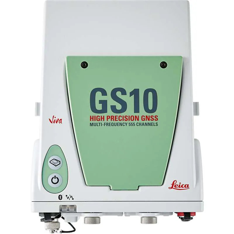
The new Viva GS10 makes up part of the new professional range of GNSS solutions. As a direct replacement for the superceeded GX1230 the GS10 offers all the flexibility of a backpack solution with all the functionality of the new Viva operating system. The GS10 is the most versatile of the new Viva range and can be configured to be used in many different formats. Often used as a reference station, back pack rover or in conjunction with external devices i.e. mobile mounted or with an echosounder for hydrographic work.
Advantages of the Leica Viva GNSS Solution:
Proven GNSS technology provided.
Leica GS10 has developed over years with by utilising the knowledge and experience gained and delivering the expectations required with Leica GNSS including reliability and accuracy.
SmartCheck provides Real Time Kinematic data-processing to guarantee accurate and precise results
SmartTrack for GNSS satallite constellation tracking
SmartRTK – delivering reliable and consistent results on all networks
Convertible communication devices with SIM cards for field base stations and RTK rovers.
Upgrade the sensor at any time to add extra functionality when needed.
Built for the harsh working conditions, the GS10 is suited for tough environments.
Protected to IP67 standards against dust
Built for temperatures -40°C to +65°C
Leica Geosystems
Leica Geosystems Saudi Arabia – Precision Meets Innovation
Introduction
Leica Geosystems Saudi Arabia delivers unmatched precision, durability, and advanced geospatial performance for professionals across construction, infrastructure, mining, and agriculture. For over 200 years, Leica has pioneered surveying instruments, GNSS/GPS systems, laser scanners, and software platforms that empower projects worldwide.
Trusted Worldwide, Available Locally in Saudi Arabia
Founded in Switzerland, Leica Geosystems has built a legacy of engineering excellence. Now available in Saudi Arabia through authorized dealers, Leica Geosystems Saudi Arabia products are adapted for the region’s challenging environments—providing local support, training, and calibrated precision.
Innovation in Every Leica Geosystems Product
Ranging from sophisticated total stations and GNSS receivers to mobile mapping and high-definition laser scanners, Leica Geosystems Saudi Arabia offers real-time accuracy and seamless digital workflows that boost project efficiency and reduce field downtime.
Key Achievements & Milestones
Over 200 years of geomatics innovation
Inventor of the world’s first digital level and early laser distance meters
Reality capture systems deployed in 100+ countries
Trusted in major infrastructure, metro, and oil & gas surveying
Adopted by engineers, surveyors, and government agencies worldwide
Why Choose Leica Geosystems in Saudi Arabia?
Localized support: Technical assistance, training, and product availability through authorized dealers
Unmatched accuracy: Instruments deliver centimeter-level precision and durability
Comprehensive portfolio: Full range from DISTO distance meters to robotic total stations and reality capture systems
Smart integration: Compatible with Hexagon, Autodesk, and other industry-leading software platforms
Leica Product Range in KSA
Leica Total Stations – Manual and robotic total stations for construction and high-precision surveying.
Leica Mobile Mapping Systems – Pegasus TRK Neo, Pegasus:Backpack, BLK2GO for vehicle, wearable, and handheld 3D capture
Discover how Leica Geosystems Saudi Arabia solutions can elevate your next project. Reach out to your authorized local distributor to request demos, pricing, and expert consultation tailored to your requirements.
Leica Geosystems is a world leader in precision surveying and geospatial solutions with over 200 years of expertise. From total stations and GNSS/GPS receivers to 3D laser scanning systems, Leica products deliver exceptional accuracy and reliability for construction, infrastructure, and mapping projects in Saudi Arabia and worldwide.