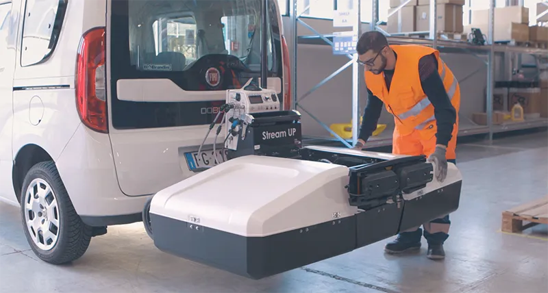
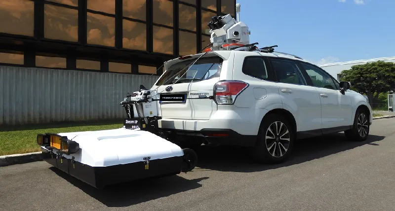
Stream UP is a next-generation 3D ground penetrating radar (GPR) designed for fast, non-invasive underground utility detection and mapping. Featuring an elevated multi-channel antenna array, Stream UP delivers high-resolution data and uniform performance across every survey. Its lightweight design and seamless integration with advanced processing software enable precise results from field acquisition to final reporting making it the ideal solution for utility locating, infrastructure design, and asset management.
Maximum depth, high resolution and versatile design for superior productivity in underground surveys.

Stream UP is an advanced multi-channel, multi-frequency, double-polarized, and lightweight ground penetrating radar (GPR) system engineered for large-scale underground utility mapping. It simplifies the entire workflow—before, during, and after data acquisition—to deliver faster, cleaner, and more reliable results.
Stream UP operates efficiently in urban environments without interrupting traffic flow, even at speeds of up to 150 km/h (recommended acquisition speed: 60 km/h). Its compact design allows transportation on the same vehicle used for data collection, offering unmatched flexibility and mobility in the field.
Easy to assemble directly on site, Stream UP requires only two people for setup and just one operator to begin data collection. The non-contact, suspended design eliminates ground friction, significantly reducing mechanical stress and lowering maintenance needs over time.
Stream UP’s portability means there’s no need for large vehicles or special road permits. Simply mount, connect, and start surveying.
Part of the renowned Stream family of GPR systems, Stream UP represents the next level of subsurface investigation technology. Explore other models in the family: Stream DP, Stream T, and Stream X—each tailored for specific site and depth requirements.
Benefits of Stream UP
- Lightweight shell: for effortless transportation and mobility between sites.
- Modular structure: enables quick assembly with no more than two people required.
- Exceptional data quality: the advanced eDAD-S Control Unit, dense antenna array, and dynamic stacking ensure top-tier performance even at high speed.
- Traffic-compliant design: mount and go—no escort vehicle or downtime needed.
- Embedded anti-collision system: enhances safety through an intelligent suspended frame design.
- Remote radar control: intuitive operation via uMap software, offering unlimited data-size management and smooth field navigation.
- Pegasus:Two Ultimate integration: synchronize radar data with LiDAR point clouds easily and accurately.
- Cloud-based remote diagnostics: boost uptime and support efficiency through transparent, real-time system monitoring and data sharing.

Easy to Assemble
Logistics are effortless with Stream UP, thanks to its smart, lightweight, and modular design. The system can be transported to any survey site without speed limitations and is ready for operation within minutes. Assembly is simple and efficient — only two operators are required for setup, and just one person is needed for transportation and full system operation.
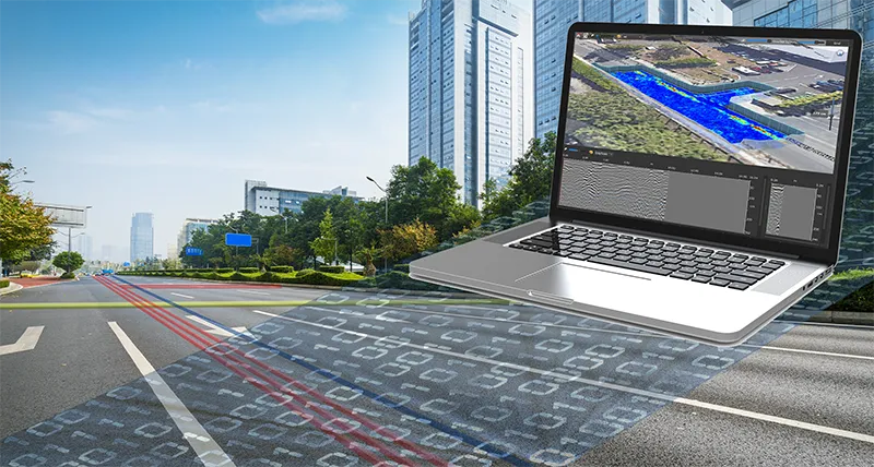
Innovative in Data Processing
Stream UP takes subsurface analysis to the next level with powerful, next-generation software solutions for advanced data processing and interpretation.
- IQMaps: a high-performance post-processing platform with built-in cloud integration, designed for faster, smarter, and more automated data analysis.
- AiMaps 2.0: delivers an intelligent 3D visualization of underground utilities, supporting safer operations and better decision-making across every stage of the project.
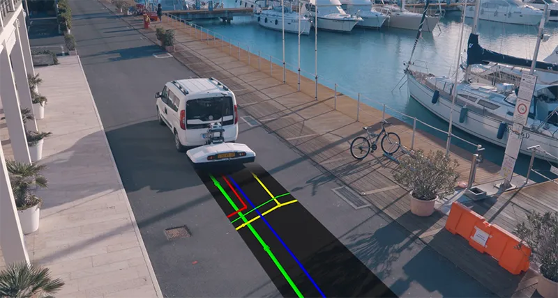
Suspended in Data Acquisition
Stream UP combines compact design with advanced performance, maintaining IDS GeoRadar’s proven dual-polarized antenna technology. Its innovative suspended modular frame enhances safety through a reinforced shell structure and integrated anti-collision system.
The new uMap acquisition software, equipped with seamless cloud connectivity, enables complete remote control of the radar—eliminating any physical link between the vehicle and the Stream UP unit. This design ensures safer, smoother data acquisition and maximum operational efficiency in the field.
Integration with Pegasus:Two Ultimate
Stream UP seamlessly integrates with the Pegasus:Two Ultimate system to deliver synchronized acquisition of Ground Penetrating Radar (GPR), LiDAR, and camera data at speeds of up to 60 km/h.
This advanced combination creates a unified platform that captures and correlates above- and below-ground geospatial information in real time. The result is a precise and efficient reconstruction of surface and subsurface assets, providing unmatched insight for infrastructure, utility, and mapping applications.
APS | Accurate Positioning System
The all-in-one precise positioning solution
The APS module is a premium accurate positioning system that combines GNSS + INS technology from NovAtel with advanced trajectory algorithms to deliver the most precise radar data, even in areas with weak or no satellite coverage. From urban canyons to tree-lined roads, tunnels, and underpasses, APS ensures consistent accuracy wherever your survey takes place.
This turn-key positioning upgrade minimizes both time and cost in the data-collection and processing phases. The unit mounts directly to the central frame of Stream UP in under ten minutes, requiring no mechanical modifications.
All setup, diagnostics, and trajectory data management are handled intuitively through uMap and IQMaps software, ensuring a seamless workflow from field to office.
Map your targets with confidence and precision — APS delivers exceptional positioning accuracy in every environment using a single, integrated module.
AiMaps 2.0
Artificial Intelligence for smarter underground mapping
AiMaps 2.0 harnesses the power of Artificial Intelligence to dramatically enhance utility surveying and detection efficiency. This intelligent software provides clearer and more detailed visualizations than ever before, helping users interpret subsurface data quickly and accurately.
By transforming complex radar signals into intuitive, easy-to-read outputs, AiMaps 2.0 delivers meaningful performance gains—empowering safer operations and better-informed decision-making throughout every stage of the project.
Stream UP Video
For privacy reasons YouTube needs your permission to be loaded. For more details, please see our Privacy Policy.
APS Video
For privacy reasons YouTube needs your permission to be loaded. For more details, please see our Privacy Policy.
Leica Geosystems
Leica Geosystems Saudi Arabia – Precision Meets Innovation
Introduction
Leica Geosystems Saudi Arabia delivers unmatched precision, durability, and advanced geospatial performance for professionals across construction, infrastructure, mining, and agriculture. For over 200 years, Leica has pioneered surveying instruments, GNSS/GPS systems, laser scanners, and software platforms that empower projects worldwide.
Trusted Worldwide, Available Locally in Saudi Arabia
Founded in Switzerland, Leica Geosystems has built a legacy of engineering excellence. Now available in Saudi Arabia through authorized dealers, Leica Geosystems Saudi Arabia products are adapted for the region’s challenging environments—providing local support, training, and calibrated precision.
Innovation in Every Leica Geosystems Product
Ranging from sophisticated total stations and GNSS receivers to mobile mapping and high-definition laser scanners, Leica Geosystems Saudi Arabia offers real-time accuracy and seamless digital workflows that boost project efficiency and reduce field downtime.
Key Achievements & Milestones
-
Over 200 years of geomatics innovation
-
Inventor of the world’s first digital level and early laser distance meters
-
Reality capture systems deployed in 100+ countries
-
Trusted in major infrastructure, metro, and oil & gas surveying
-
Adopted by engineers, surveyors, and government agencies worldwide
Why Choose Leica Geosystems in Saudi Arabia?
-
Localized support: Technical assistance, training, and product availability through authorized dealers
-
Unmatched accuracy: Instruments deliver centimeter-level precision and durability
-
Comprehensive portfolio: Full range from DISTO distance meters to robotic total stations and reality capture systems
-
Smart integration: Compatible with Hexagon, Autodesk, and other industry-leading software platforms
Leica Product Range in KSA
-
Leica Total Stations – Manual and robotic total stations for construction and high-precision surveying.
-
Leica Mobile Mapping Systems – Pegasus TRK Neo, Pegasus:Backpack, BLK2GO for vehicle, wearable, and handheld 3D capture
-
Leica GPS & GNSS Equipment – GS18 I GNSS RTK rover, iCON GPS smart antennas offering tilt-compensated precision positioning
-
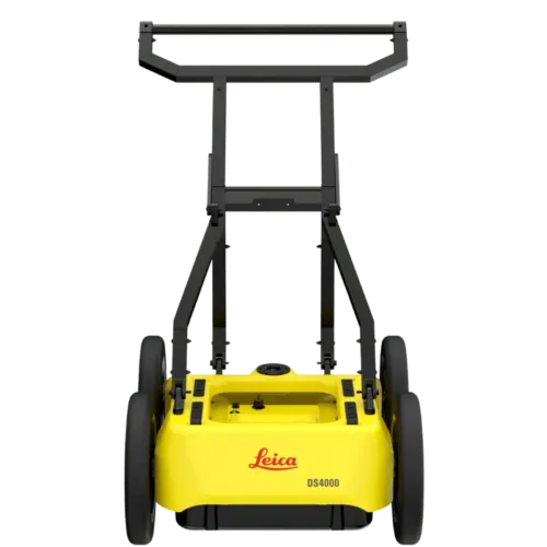
Ground Penetrating Radar (GPR) – Leica GPR solutions for accurate subsurface mapping
-
Leica Laser Scanners – ScanStation P‑Series, RTC360, BLK360, and BLK2FLY for HD 3D scanning and digital twin workflows
-
Leica DISTO & Leica Levels – Leica DISTO™ meter series and LINO/Rugby laser levels for point‑to‑point measurements and leveling
Leica Cyclone Software Portfolio
-
Cyclone REGISTER 360 PLUS – Guided workflows to register and visualize point cloud datasets with automation for efficient office workflows
-
Cyclone 3DR – End-to-end solution to analyze and model point clouds into actionable 3D deliverables
-
Cyclone Enterprise – On‑premise project and data management platform for centralized reality capture workflows
-
Cyclone Cloud – Subscription-based SaaS portal offering centralized license management and secure cloud-hosted service access
Get in Touch - Contact Us
Discover how Leica Geosystems Saudi Arabia solutions can elevate your next project. Reach out to your authorized local distributor to request demos, pricing, and expert consultation tailored to your requirements.
Official Website: www.leica-geosystems.com
Leica Geosystems is a world leader in precision surveying and geospatial solutions with over 200 years of expertise. From total stations and GNSS/GPS receivers to 3D laser scanning systems, Leica products deliver exceptional accuracy and reliability for construction, infrastructure, and mapping projects in Saudi Arabia and worldwide.