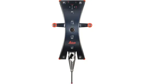
The perfect match: A handheld probing tool for the Leica Absolute Tracker AT403. The Leica B-Probe can gather hidden 3D points in a measurement volume of 20 m (ø). For very large structures that require highly accurate measurements, the volume can be extended within a working volume of 320 m (ø) with virtually no loss in probing accuracy by completing a laser tracker move station.
Leica B-Probe at a glance:
20 m probing volume (ø)
Accuracy Uxyz = +- 0.2 mm over full range
Relocation volume of up to 320 m (ø)
Ultra-portable small footprint system architecture
Hand-Luggage Metrology Solution
Consequent pursuit of portability: the entire laser tracker weighs only 8 kg and fits into a micro-car or a hand luggage bin.
Size Does Not Matter
The Leica B-Probe can gather hidden 3D points in a measurement volume of 20 m around the Leica Absolute Tracker AT403. With endless telescope rotation, the Leica AT403 covers a full 360° horizontal and a 290° vertical dome.
Leica Geosystems
Leica Geosystems Saudi Arabia – Precision Meets Innovation
Introduction
Leica Geosystems Saudi Arabia delivers unmatched precision, durability, and advanced geospatial performance for professionals across construction, infrastructure, mining, and agriculture. For over 200 years, Leica has pioneered surveying instruments, GNSS/GPS systems, laser scanners, and software platforms that empower projects worldwide.
Trusted Worldwide, Available Locally in Saudi Arabia
Founded in Switzerland, Leica Geosystems has built a legacy of engineering excellence. Now available in Saudi Arabia through authorized dealers, Leica Geosystems Saudi Arabia products are adapted for the region’s challenging environments—providing local support, training, and calibrated precision.
Innovation in Every Leica Geosystems Product
Ranging from sophisticated total stations and GNSS receivers to mobile mapping and high-definition laser scanners, Leica Geosystems Saudi Arabia offers real-time accuracy and seamless digital workflows that boost project efficiency and reduce field downtime.
Key Achievements & Milestones
Over 200 years of geomatics innovation
Inventor of the world’s first digital level and early laser distance meters
Reality capture systems deployed in 100+ countries
Trusted in major infrastructure, metro, and oil & gas surveying
Adopted by engineers, surveyors, and government agencies worldwide
Why Choose Leica Geosystems in Saudi Arabia?
Localized support: Technical assistance, training, and product availability through authorized dealers
Unmatched accuracy: Instruments deliver centimeter-level precision and durability
Comprehensive portfolio: Full range from DISTO distance meters to robotic total stations and reality capture systems
Smart integration: Compatible with Hexagon, Autodesk, and other industry-leading software platforms
Leica Product Range in KSA
Leica Total Stations – Manual and robotic total stations for construction and high-precision surveying.
Leica Mobile Mapping Systems – Pegasus TRK Neo, Pegasus:Backpack, BLK2GO for vehicle, wearable, and handheld 3D capture
Discover how Leica Geosystems Saudi Arabia solutions can elevate your next project. Reach out to your authorized local distributor to request demos, pricing, and expert consultation tailored to your requirements.
Leica Geosystems is a world leader in precision surveying and geospatial solutions with over 200 years of expertise. From total stations and GNSS/GPS receivers to 3D laser scanning systems, Leica products deliver exceptional accuracy and reliability for construction, infrastructure, and mapping projects in Saudi Arabia and worldwide.