DJI MATRICE 400

Contact Details

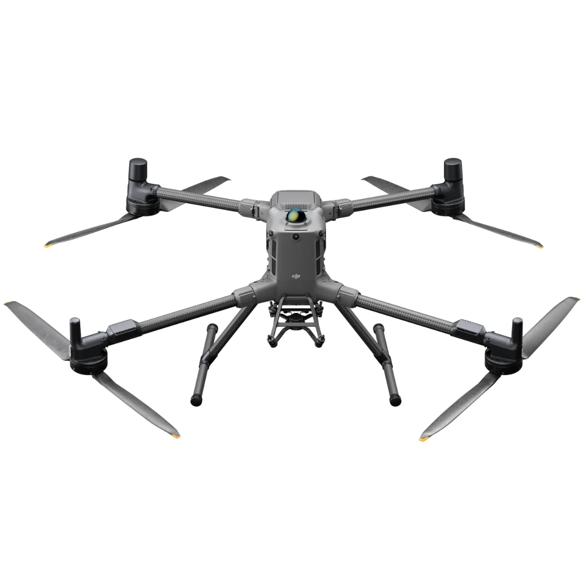
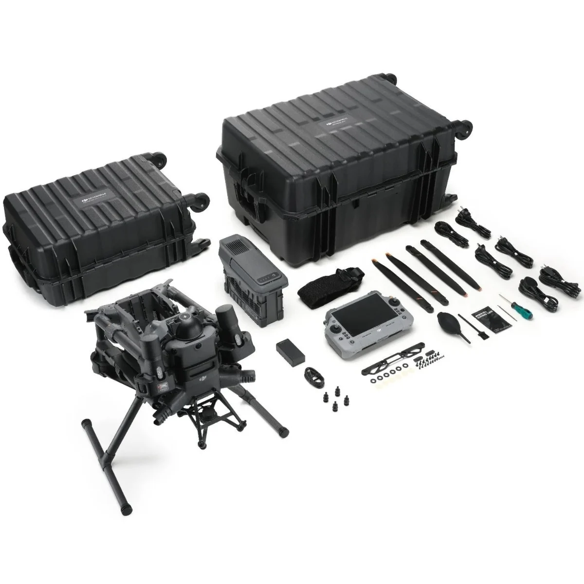
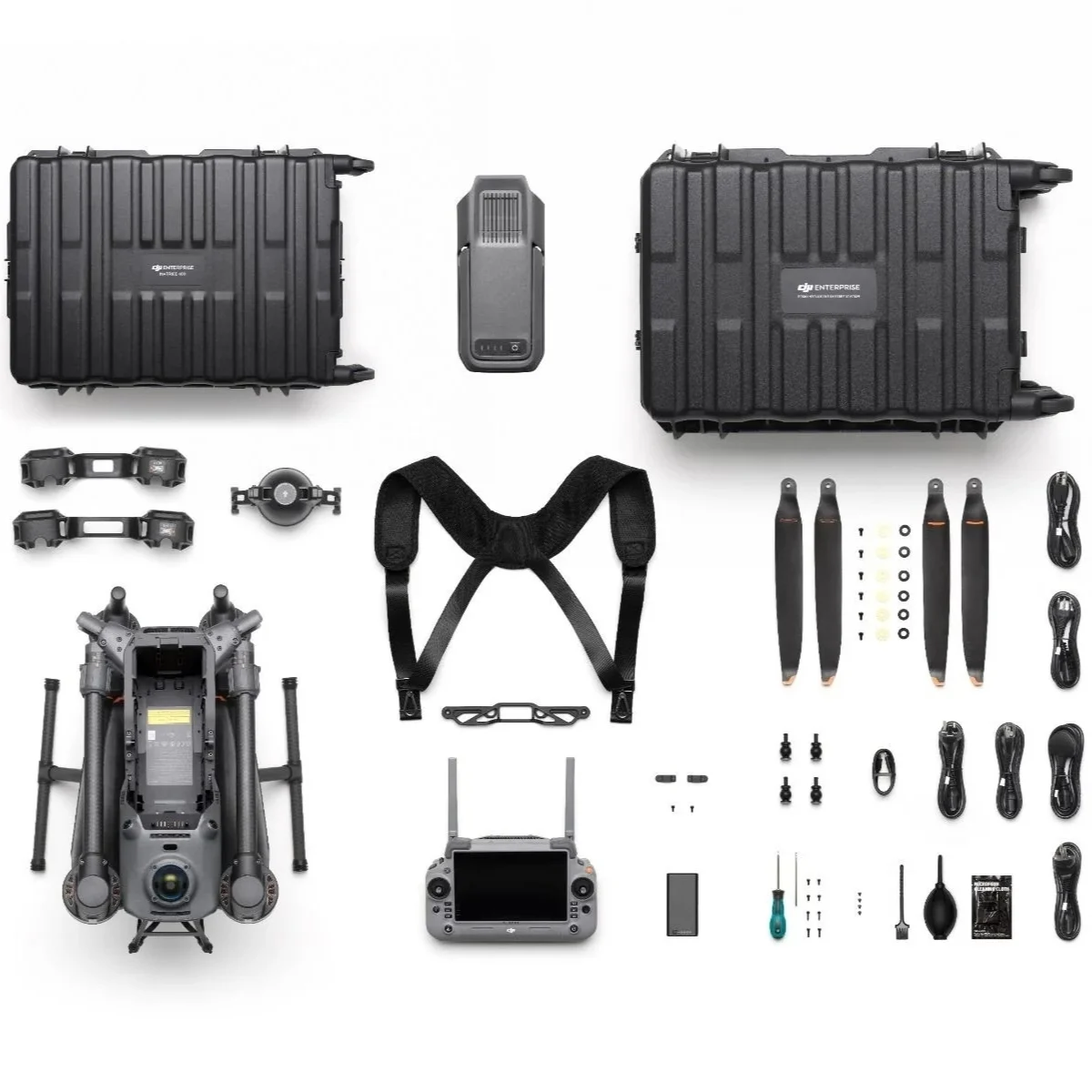
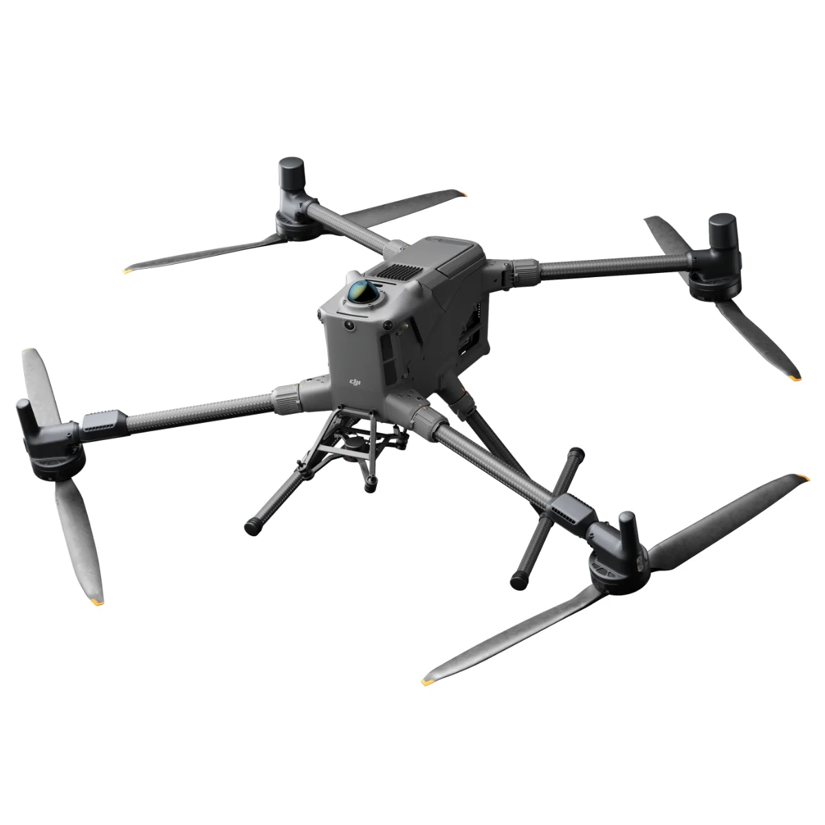
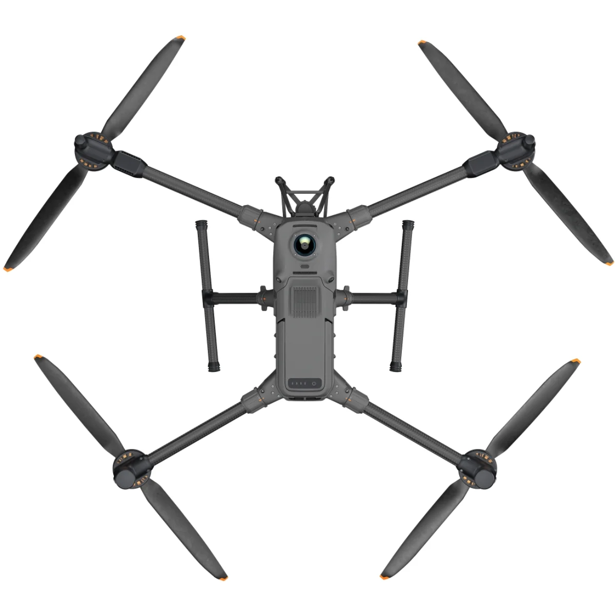
The DJI Matrice 400 is a powerful industrial UAV designed for professional aerial mapping, survey-grade data capture, and advanced inspection workflows. Built for reliability, extended flight performance, and flexible payload integration, this enterprise drone empowers engineers, surveyors, and inspection teams with precision imaging, automated mission planning, and robust flight control for complex project requirements. Ideal for infrastructure monitoring, construction site analysis, and large-area geospatial data acquisition in demanding environments.

  • Enterprise-grade industrial UAV built for mission stability and long-duration flight
  • Survey-accurate aerial mapping with real-time positioning workflow support
  • Heavy-duty platform for infrastructure inspection, site monitoring, and 3D mapping
  • Flexible payload integration for thermal, zoom, and high-resolution imaging sensors
  • Intelligent automated mission planning for repeatable data capture
  • High-wind resistance and rugged flight reliability for complex environments
  • Live telemetry and precision imaging for accurate aerial assessments
  • Optimized for large-area geospatial data acquisition and field-to-office workflows
Category:

DJI Matrice 400 is a leading enterprise UAV platform engineered for industrial mission performance, offering up to 59 minutes of flight endurance and supporting a payload of 6 kg. Its integrated rotating LiDAR and mmWave radar deliver powerline-grade obstacle awareness using advanced sensing technologies, including mmWave detection for complex environments. The platform enables secure, high-quality video transmission through O4 Enterprise Enhanced and airborne relay communication, improving operational safety and control. Equipped to support visible-thermal Smart Detection, AR projection guidance, ship-based launch and recovery, and automated mission execution, the system is optimized for emergency response, power infrastructure inspection, 3D mapping, construction monitoring, and AEC aerial data workflows.

Extended Flight Time, High Speed Performance

Up to 6kg Payload Capacity

Safe and Reliable Flight

Enhanced Intelligence and Efficiency

Automated Operations

Comprehensive Accessory Upgrades

DJI Care Enterprise

Extended Flight Time,
High Speed Performance

Matrice 400 delivers exceptional flight performance, providing up to 59 minutes of forward flight time with payload and up to 53 minutes of stable hovering endurance. This extended operational capability supports long-duration and mission-critical tasks such as search and rescue, firefighting, and large-area mapping. Designed for demanding environments, the platform can reliably detect and avoid large obstacles such as buildings and mountainous terrain while operating at flight speeds of up to 25 m/s, ensuring safer and more efficient operations.

Multi-Payload, Multi-Scene

Matrice 400 is built to handle demanding missions with a maximum payload capacity of 6 kg, providing the flexibility required across a wide range of professional applications. It supports smooth configuration changes between a single downward gimbal and a dual downward gimbal, while an additional third gimbal connector on the underside expands payload options further. Equipped with four external E-Port V2 ports, the aircraft enables the simultaneous installation of up to seven payloads, allowing operators to adapt quickly to complex, multi-sensor mission requirements.

Depending on mission requirements, Matrice 400 can be configured with a wide range of payload options, including the Zenmuse H30 Series, L2, P1, S1 Spotlight, V1 Speaker, Manifold 3, as well as compatible third-party payloads. This modular compatibility extends operational flexibility and allows operators to fully leverage the capabilities of the DJI ecosystem across diverse applications.

Zenmuse H30 Series

The Zenmuse H30 Series integrates five major modules—a wide-angle camera, a zoom camera, an infrared thermal camera, a laser range finder, and an NIR auxiliary light. Employing cutting-edge intelligent algorithms, it revolutionizes perception and imaging standards, transcending the limitations of day and night vision.

Zenmuse L3

Zenmuse L3 features a 1535nm long-range LiDAR, dual 100MP RGB mapping cameras, and a high-precision POS system. It can be mounted on Matrice 400 using the Zenmuse L3 single gimbal connector, accelerating geospatial data acquisition.

Zenmuse P1

Zenmuse P1 integrates a full-frame sensor with interchangeable fixed-focus lenses on a 3-axis stabilised gimbal. Designed for photogrammetry flight missions, it takes efficiency and accuracy to a whole new level.

Zenmuse H30 Series

The Zenmuse H30 Series integrates five major modules—a wide-angle camera, a zoom camera, an infrared thermal camera, a laser range finder, and an NIR auxiliary light. Employing cutting-edge intelligent algorithms, it revolutionises perception and imaging standards, transcending the limitations of day and night vision.

Zenmuse V1

Zenmuse V1 is DJI’s first loudspeaker designed for multi-payload drone platforms. It boasts high volume and long broadcast distance, and supports multiple broadcast modes, making it ideal for scenarios like public safety, emergency rescue, and more.

Manifold 3

Manifold 3 packs an impressive 100 TOPS of computing power into a compact unit weighing about 120 g. It can be mounted onto Matrice 400 drone platform, optimising efficiency across various operational missions with its robust processing.

Flight Time

Estimate the Matrice 400’s flight time based on payload configuration.

Safe and Reliable Flight

Built for Challenging
Conditions

Matrice 400 has a protection rating of IP55 [9], allowing it to operate reliably in challenging conditions including heavy dust or rain. It also maintains stable performance across temperatures from -20° to 50° C (-4° to 122° F), delivering consistent results in both hot and cold conditions.

IP55

IP Rating

-20° to 50° C (-4° to 122° F)

Operating Temperature

Power-Line-Level Obstacle Sensing

The Matrice 400’s advanced obstacle sensing system integrates rotating LiDAR, high-precision mmWave radar, and full-colour low-light fisheye vision sensors [13], pushing detection capabilities to unprecedented levels. The system detects even small obstacles like high-voltage power lines across mountainous terrain — even in darkness. It can penetrate rain and fog to sense its surroundings, providing enhanced safety in challenging weather conditions.

Robust Video Transmission

Near High-Rise Buildings

Thanks to the ten-antenna system on the aircraft and the high-gain phased array antenna system on the remote controller, the O4 Enterprise Enhanced Video Transmission System can achieve image transmission up to 40 km [10].

Matrice 400 also supports the sub2G frequency band [5], and when equipped with two DJI Cellular Dongle 2 [11], it can automatically switch to the better available carrier network, providing a more stable signal even in urban interference environments or remote regions.

Near High-Rise Buildings

Matrice 400 has a built-in video transmission relay module. With this setup, one Matrice 400 can serve as a relay drone, flying high to provide relay signals for another Matrice 400 operating at a greater distance. This capability significantly extends the transmission range, making it ideal for search and rescue tasks as well as inspections in mountainous areas.

Aircraft Fusion Positioning

The omnidirectional sensing performance [12] brought by rotating LiDAR, high-precision mmWave radar, and full-colour low-light fisheye vision sensors provides Matrice 400 with strong positioning capabilities. It can fly stably close to glass-facade buildings or wind turbine blades and safely return from building edges, mountain bases, or bridge sides even when the return point has not been updated.

Full-Colour Vision Assist

The four full-colour low-light fisheye vision sensors on the aircraft provide Full-Colour Vision Assist [13] to ensure safer flight.

Enhanced Intelligence and Efficiency

Smart Detection

With Zenmuse H30 Series’ visible and thermal imaging, Matrice 400 can detect vehicles, vessels, and subjects during search and rescue operations or routine flights. It also supports switching to other models, enabling the expansion of application scenarios. Additionally, it supports high-res grid photos and features powerful tracking capabilities.

Smart AR Projection

Real-Time Terrain Follow

Matrice 400 supports Real-Time Terrain Follow flight in any horizontal direction, maintaining a stable relative altitude above the ground throughout operations. This capability can be activated during both manual flight and automated mission routes, ensuring consistent flight behavior across varied terrain.

In large-scale search and rescue operations, terrain following helps keep ground targets at a consistent size on the remote controller display, minimizing the need for frequent zoom adjustments and improving operational efficiency. During mapping missions, it enables the maintenance of a consistent ground sampling distance (GSD), supporting the acquisition of accurate and high-precision mapping data.

Takeoff and Landing on Ships

To meet the demands of offshore operations such as maritime patrol and wind turbine inspection, Matrice 400 is capable of ship-based takeoff and landing. It supports takeoff from stationary vessels and precise landing on moving ships, expanding operational flexibility in marine environments. By recognizing landing point patterns on the vessel deck, the aircraft enables safe, accurate, and controlled landings, even under dynamic conditions.

Intelligent Flight Modes

Easier Automated Operations

Comprehensive Accessory Upgrades

BS100 Intelligent Battery Station

DJI RC Plus 2 Enterprise Enhanced Remote Controller features a new high-brightness screen that remains clearly visible even in direct sunlight. It has an IP54 protection rating and can operate in temperatures ranging from -20° to 50° C (-4° to 122° F). Equipped with the O4 Enterprise Enhanced Video Transmission, it features a built-in high-gain antenna array, providing strong performance. It also supports the sub2G module and 4G hybrid transmission solutions, ensuring stable and smooth video feeds in both urban high-rise and mountainous environments.

DJI Cellular Dongle 2

The DJI Cellular Dongle 2 enables 4G network video transmission and operates in coordination with the O4 Enterprise Enhanced Video Transmission System, supporting stable and secure flight operations in complex environments. It also provides mobile network connectivity for the remote controller, enhancing communication reliability and operational continuity.

TB100 Battery

The TB100 Intelligent Flight Battery is built with high-performance, high-energy cells and supports up to 400 charging cycles, helping reduce overall cost per flight. It features enhanced heat dissipation and an integrated self-heating system, supporting reliable operation across a wide range of environmental conditions.

TB100C Tethered Battery

The TB100C Tethered Battery is compatible with third-party tethered lighting and communication systems, enabling long-duration aerial lighting and cable-based communication base station operations. Reserved interface ports support third-party development of automated recharging solutions, including drone dock systems, expanding deployment and automation capabilities.

BS100 Intelligent Battery Station

The intelligent battery station provides a complete solution for charging, storage, and transportation. It supports sequential charging of up to three TB100 batteries and two WB37 batteries, enabling efficient battery management in the field. With a fast charging time of just 45 minutes per TB100 battery, it supports continuous, uninterrupted flight operations. When operating in Silent Mode, noise levels are reduced to as low as 36 dB, making it suitable for noise-sensitive environments.

D-RTK 3 Multifunctional Station

The D-RTK 3 Multifunctional Station can operate as a base station, delivering centimeter-level positioning accuracy to multiple drones simultaneously. Its Rover Station Mode, when used with the DJI Enterprise app and DJI Terra, forms a complete solution for high-precision aerial surveying, supporting accurate data collection and reliable operational performance.

Software Designed for Industries

Open Developer Ecosystem

Intelligent Algorithm Developer

Provides the necessary model training tools and third-party developer certification process to access onboard computing capability, helping to expand new application fields for drones.

PSDK

The newly upgraded E-Port V2 supports USB 3.0 high-speed payload communication and delivers up to 120 watts of power per port. The E4 port of the E-Port V2 can be expanded into four payload ports via the E-Port Hub expansion plate, unlocking broader application scenarios and greater potential for the Matrice 400.

MSDK

Mobile SDK 5 simplifies the development of apps to control the Matrice 400. It comes with fully open-source, production-level code samples with core modules adapted from DJI Pilot 2, guaranteeing high reliability.

Cloud API

With DJI Pilot 2’s built-in Cloud API (MQTT-based protocol), you can directly connect the Matrice 400 to third-party cloud platforms. Access the drone’s hardware, video live-stream, and photo data without having to develop an app.

Open Data Access

Developers can leverage payload, LiDAR, mmWave radar, and vision sensor data interfaces to build innovative applications and expand the DJI ecosystem.

User Data Security

Media Data Encryption

Local Data Mode

One-Tap Clear Logs

AES-256 Video Transmission Encryption

Cloud API

Application Scenarios

Public Safety

Power Line Inspection

Geographic Information

Oil and Gas

Renewable Energy

Roads and Bridges

Maritime

Water Conservation

Go to Top