Leica Absolute Scanner LAS-XL

Contact Details

The world’s first large-scale handheld 3D laser scanner

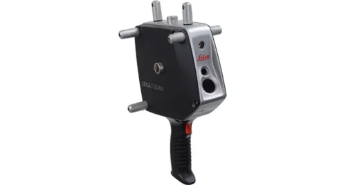
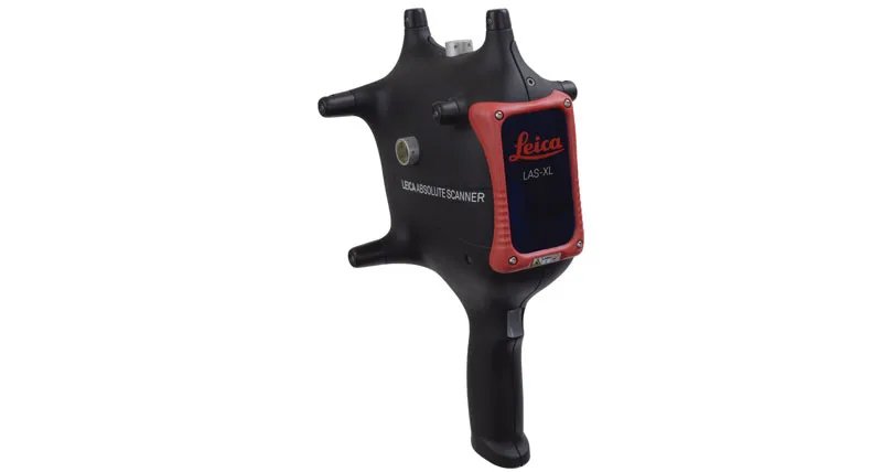
The new Leica Absolute Scanner LAS-XL is a handheld laser scanner designed to meet the needs of emerging 3D scanning applications for which higher productivity is the priority. Working in conjunction with the Leica Absolute Tracker AT960 range of high-end laser trackers, the LAS-XL opens the door to previously infeasible large-scale 3D digitisation tasks.

LAS-XL_inside train_StadlerIn a world of CAE and precision manufacturing, detailed digital modelling of components and pieces is more and more in demand. For parts that are larger and less feature-dense, traditional laser scanning methods present a massive productivity challenge to this requirement, with full digitisation and CAD modelling often becoming an unnecessarily time-consuming process.

The LAS-XL rethinks portable laser scanning by significantly increasing available 3D scanning area. A scan line of up to 600 millimetres wide delivers considerable productivity improvements, with scanning process times now up to three times faster. Hidden-feature access is transformed by an up to 1000 millimetre stand-off, making digitising deep cavity features easier than ever before while also improving access to difficult to reach measurement surfaces without repositioning of the laser tracker. These improvements are achieved while retaining metrological accuracy to within just 150 microns, an accuracy level ideal for less complex surfaces and pieces.

The LAS-XL also delivers all the well-established features familiar to the Leica Absolute Scanner range, from the revolutionary flying dot scanning concept and automatic exposure control to automatic scanner recognition and simple scan profile selection.

Large-scale, high-productivity, laser scanning and three-dimensional digitisation has never before been achievable within an easy-to-use package. It is now with the Leica Absolute Scanner LAS-XL.

SKU: Leica Absolute Scanner LAS-XL Category:

Description

Features

Super-Wide Scan Line
Never-before-seen measurement scan-line width of up to 600 millimetres makes the full digitisation of large surfaces faster and easier than ever before.

Extra-Large Stand-Off

Unprecedented measurement stand-off of up to 1000 millimetres delivers excellent access to hard to reach hidden measurement areas, opening up a new world of laser scanner applications that were previously out of reach.

Metrological Accuracy

With accuracy retained to within 300 microns, the LAS-XL is the perfect tool for digitising the larger, less complex surfaces that would typically demand infeasible measurement process times for a laser scanner.

Multi-Surface Capability

Multiple materials and finishes scannable within a single pass with no settings changes using Hexagon’s well-established flying-dot scanning technology that automatically adjusts laser intensity.

Battery Powered Portability
With the optional battery power configuration, the LAS-XL requires just a single network cable, offering complete portability for laser scanner measurements on the move.

Self-Identifying Sensor
The LAS-XL laser scanner is automatically recognised by the Leica Absolute Tracker AT960, allowing quick changes between 3D scanning, probing and reflector measurement.

On-Scanner Profile Selection
Customisable pre-set scanning modes selectable from the body of the scanner, giving access to the right measurement profile at the right time without software adjustments.

Multisensory feedback
Haptic, acoustic and visual feedback to guide you to the optimum measurement position with the minimum of training.

Robust IP50-rated design
Designed for durability in tough shop floor and workshop conditions, the IP50 ingress protection rating of the LAS-XL means laser scanning is ready to go wherever it’s needed.

RDS software interface

Based on the proven RDS software interface that is the foundation of the Hexagon range of portable measuring arms, for full expert confidence when it comes to system checks, compensation and certifications.

Brand

Leica Geosystems

Leica Geosystems Saudi Arabia – Precision Meets Innovation

Introduction

Leica Geosystems Saudi Arabia delivers unmatched precision, durability, and advanced geospatial performance for professionals across construction, infrastructure, mining, and agriculture. For over 200 years, Leica has pioneered surveying instruments, GNSS/GPS systems, laser scanners, and software platforms that empower projects worldwide.

Trusted Worldwide, Available Locally in Saudi Arabia

Founded in Switzerland, Leica Geosystems has built a legacy of engineering excellence. Now available in Saudi Arabia through authorized dealers, Leica Geosystems Saudi Arabia products are adapted for the region’s challenging environments—providing local support, training, and calibrated precision.

Innovation in Every Leica Geosystems Product

Ranging from sophisticated total stations and GNSS receivers to mobile mapping and high-definition laser scanners, Leica Geosystems Saudi Arabia offers real-time accuracy and seamless digital workflows that boost project efficiency and reduce field downtime.

Key Achievements & Milestones

  • Over 200 years of geomatics innovation

  • Inventor of the world’s first digital level and early laser distance meters

  • Reality capture systems deployed in 100+ countries

  • Trusted in major infrastructure, metro, and oil & gas surveying

  • Adopted by engineers, surveyors, and government agencies worldwide

Why Choose Leica Geosystems in Saudi Arabia?

  • Localized support: Technical assistance, training, and product availability through authorized dealers

  • Unmatched accuracy: Instruments deliver centimeter-level precision and durability

  • Comprehensive portfolio: Full range from DISTO distance meters to robotic total stations and reality capture systems

  • Smart integration: Compatible with Hexagon, Autodesk, and other industry-leading software platforms

Leica Product Range in KSA

  • Total Stations – Manual and robotic total stations for construction and high-precision surveying.

  • Mobile Mapping Systems – Pegasus TRK Neo, Pegasus:Backpack, BLK2GO for vehicle, wearable, and handheld 3D capture

  • GPS & GNSS Equipment – GS18 I GNSS RTK rover, iCON GPS smart antennas offering tilt-compensated precision positioning

  • Ground Penetrating Radar (GPR) – Leica GPR solutions for accurate subsurface mapping

  • Laser Scanners – ScanStation P‑Series, RTC360, BLK360, and BLK2FLY for HD 3D scanning and digital twin workflows

  • DISTO Laser Distance Meters & Levels – Leica DISTO™ meter series and LINO/Rugby laser levels for point‑to‑point measurements and leveling

Leica Cyclone Software Portfolio

  • Cyclone REGISTER 360 PLUS – Guided workflows to register and visualize point cloud datasets with automation for efficient office workflows

  • Cyclone 3DR – End-to-end solution to analyze and model point clouds into actionable 3D deliverables

  • Cyclone Enterprise – On‑premise project and data management platform for centralized reality capture workflows

  • Cyclone Cloud – Subscription-based SaaS portal offering centralized license management and secure cloud-hosted service access

Get in Touch - Contact Us

Discover how Leica Geosystems Saudi Arabia solutions can elevate your next project. Reach out to your authorized local distributor to request demos, pricing, and expert consultation tailored to your requirements.

Official Website: www.leica-geosystems.com

Leica Geosystems is a world leader in precision surveying and geospatial solutions with over 200 years of expertise. From total stations and GNSS/GPS receivers to 3D laser scanning systems, Leica products deliver exceptional accuracy and reliability for construction, infrastructure, and mapping projects in Saudi Arabia and worldwide.

Reviews

There are no reviews yet.

Only logged in customers who have purchased this product may leave a review.

Title

Go to Top