Leica BLK360 Imaging Laser Scanner

Contact Details

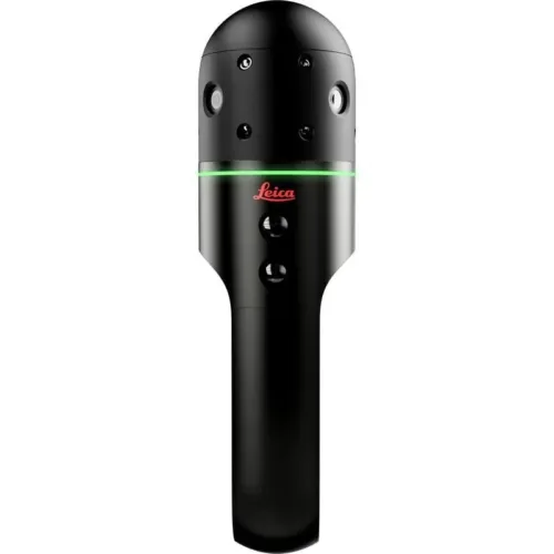
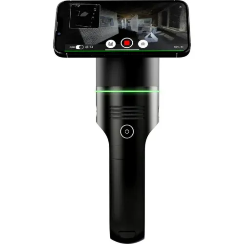
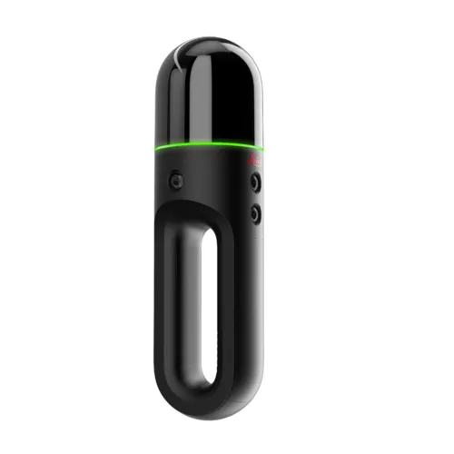
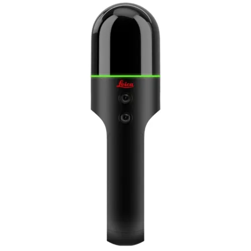
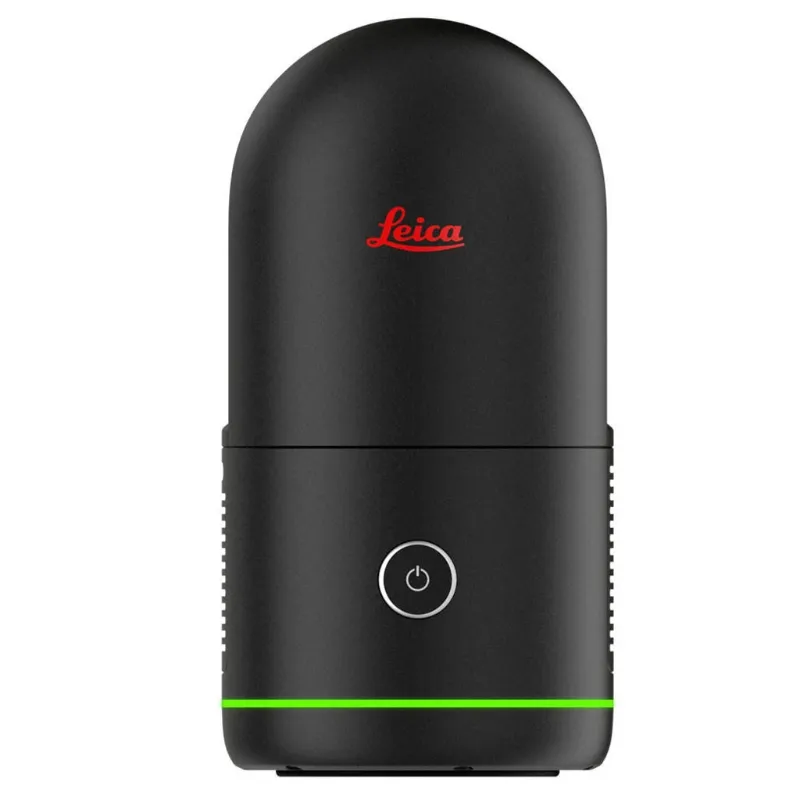
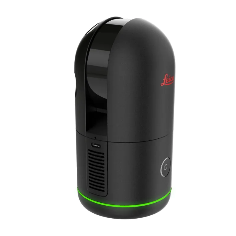
The smallest and lightest imaging laser scanner available

The Leica BLK360 captures the world around you with full-colour panoramic images overlaid on a high-accuracy point cloud. Simple to use with just the single push of one button, the BLK360 is the smallest and lightest of its kind. Anyone who can operate an iPad can now capture the world around them with high resolution 3D panoramic images.

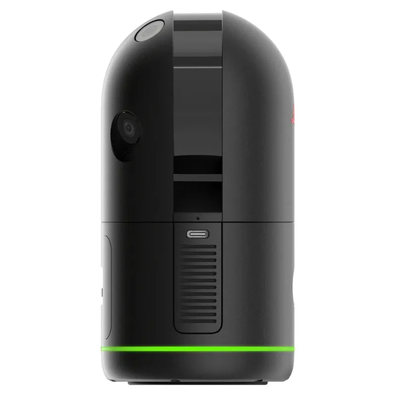
Using the ReCap Pro mobile app, the BLK360 streams image and point cloud data to iPad. The app filters and registers scan data in real time. After capture, ReCap Pro enables point cloud data transfer to a number of CAD, BIM, VR and AR applications. The integration of BLK360 and Autodesk software dramatically streamlines the reality capture process thereby opening this technology to non-surveying individuals.

Package includes:

  • Leica BLK360 Imaging Laser Scanner
  • GEB212 Lithium-Ion Battery for the BLK360
  • GKL311 Battery Charger
  • AC/DC adaptor
  • BLK360 Tripod
  • BLK360 Mission bag
SKU: Leica-BLK360 Category:

Description

BLK360 Imaging Laser Scanner

  • Allows you to scan in high, standard and fast resolutions
  • Weighs 1kg / Size 165 mm tall x 100 mm diameter
  • Less than 3 minutes for full-dome scan (in standard resolution) and 150 MP spherical image generation
  • 360,000 laser scan pts/sec

ReCap Pro Software

  • Gain complete access to ReCap Pro for desktop, web and mobile*
  • Control all aspects of the reality capture process remotely on ReCap for iPad
  • Automatically register and visualise scan data in the field
  • Mark up, tag and collaborate on scans while on the job site
  • Reduce rework requests and share reality data remotely
  • Seamless data transfer into Autodesk design software

With the combination of the BLK360 and Autodesk ReCap Pro, benefit from:

Speed
On-the-fly image and point cloud processing in the field.

Portability
Flexibility to scan wherever, whenever with the small lightweight scanner that fits into a messenger bag.

Ease of Use
Push-button scanning that automatically stitches and registers in the mobile version of ReCap Pro.

Cloud Connectivity
Better collaboration and virtualisation with cloud sync.

Simplified Data Collection
Two-in-one 360º image documentation and laser scan data.

Interoperability
Reality capture data connectivity with Autodesk’s design solutions.

Leica BLK360 Product Specifications
GENERAL
Imaging scanner 3D scanner with integrated spherical imaging system and thermography panorama sensor system
DESIGN & PHYSICAL
Housing Black anodized aluminium
Dimensions Height: 165 mm / Diameter: 100 mm
Weight 1kg
Transport cover Hood with integrated fl oorstand
Mounting mechanism Button-press quick release
OPERATION
Stand-alone operation One-button operation
Remote operation iPad app, Apple iPad Pro® 12.9” or 10.5”/iOS 10 or later
Wireless communication Integrated wireless LAN (802.11 b/g/n)
Internal memory Storage for > 100 setups
Instrument orientation Upright and upside down
POWER
Battery type Internal, rechargeable Li-Ion battery (Leica GEB212)
Capacity Typically >40 setups
SCANNING
Distance measurement system High speed time of fl ight enhanced by Waveform Digitizing (WFD) technology
Laser class 1 (in accordance with IEC 60825-1:2014)
Wavelength 830 nm
Field of view 360° (horizontal) / 300° (vertical)
Range min. 0.6 - up to 60 m
Point measurement rate up to 360’000 pts / sec
Ranging accuracy 4mm @ 10m / 7mm @ 20m
Measurement modes 3 user selectable resolution settings
IMAGING
Camera System 15 Mpixel 3-camera system, 150Mpx full dome capture, HDR, LED fl ash Calibrated spherical image, 360° x 300°
Thermal Camera Longwave infrared camera
Thermal panoramic image, 360° x 70°
PERFORMANCE
Measurement speed < 3 min for complete fulldome scan, spherical image & thermal image
3D point accuracy 6mm @ 10m / 8mm @ 20m
ENVIRONMENTAL
Robustness Designed for indoor and outdoor use
Operating temperature +5 to +40° C
Dust/Humidity Solid particle/liquid ingress protection IP54 (IEC 60529)
DATA ACQUISITION
Live image and scanned data streaming
Live data viewing and editing
Automatic tilt measurements

Brand

Leica Geosystems

Leica Geosystems Saudi Arabia – Precision Meets Innovation

Introduction

Leica Geosystems Saudi Arabia delivers unmatched precision, durability, and advanced geospatial performance for professionals across construction, infrastructure, mining, and agriculture. For over 200 years, Leica has pioneered surveying instruments, GNSS/GPS systems, laser scanners, and software platforms that empower projects worldwide.

Trusted Worldwide, Available Locally in Saudi Arabia

Founded in Switzerland, Leica Geosystems has built a legacy of engineering excellence. Now available in Saudi Arabia through authorized dealers, Leica Geosystems Saudi Arabia products are adapted for the region’s challenging environments—providing local support, training, and calibrated precision.

Innovation in Every Leica Geosystems Product

Ranging from sophisticated total stations and GNSS receivers to mobile mapping and high-definition laser scanners, Leica Geosystems Saudi Arabia offers real-time accuracy and seamless digital workflows that boost project efficiency and reduce field downtime.

Key Achievements & Milestones

  • Over 200 years of geomatics innovation

  • Inventor of the world’s first digital level and early laser distance meters

  • Reality capture systems deployed in 100+ countries

  • Trusted in major infrastructure, metro, and oil & gas surveying

  • Adopted by engineers, surveyors, and government agencies worldwide

Why Choose Leica Geosystems in Saudi Arabia?

  • Localized support: Technical assistance, training, and product availability through authorized dealers

  • Unmatched accuracy: Instruments deliver centimeter-level precision and durability

  • Comprehensive portfolio: Full range from DISTO distance meters to robotic total stations and reality capture systems

  • Smart integration: Compatible with Hexagon, Autodesk, and other industry-leading software platforms

Leica Product Range in KSA

  • Total Stations – Manual and robotic total stations for construction and high-precision surveying.

  • Mobile Mapping Systems – Pegasus TRK Neo, Pegasus:Backpack, BLK2GO for vehicle, wearable, and handheld 3D capture

  • GPS & GNSS Equipment – GS18 I GNSS RTK rover, iCON GPS smart antennas offering tilt-compensated precision positioning

  • Ground Penetrating Radar (GPR) – Leica GPR solutions for accurate subsurface mapping

  • Laser Scanners – ScanStation P‑Series, RTC360, BLK360, and BLK2FLY for HD 3D scanning and digital twin workflows

  • DISTO Laser Distance Meters & Levels – Leica DISTO™ meter series and LINO/Rugby laser levels for point‑to‑point measurements and leveling

Leica Cyclone Software Portfolio

  • Cyclone REGISTER 360 PLUS – Guided workflows to register and visualize point cloud datasets with automation for efficient office workflows

  • Cyclone 3DR – End-to-end solution to analyze and model point clouds into actionable 3D deliverables

  • Cyclone Enterprise – On‑premise project and data management platform for centralized reality capture workflows

  • Cyclone Cloud – Subscription-based SaaS portal offering centralized license management and secure cloud-hosted service access

Get in Touch - Contact Us

Discover how Leica Geosystems Saudi Arabia solutions can elevate your next project. Reach out to your authorized local distributor to request demos, pricing, and expert consultation tailored to your requirements.

Official Website: www.leica-geosystems.com

Leica Geosystems is a world leader in precision surveying and geospatial solutions with over 200 years of expertise. From total stations and GNSS/GPS receivers to 3D laser scanning systems, Leica products deliver exceptional accuracy and reliability for construction, infrastructure, and mapping projects in Saudi Arabia and worldwide.

Reviews

There are no reviews yet.

Only logged in customers who have purchased this product may leave a review.

Title

Go to Top