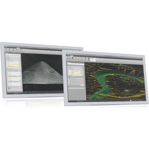
Survey CAD technicians can create topographic maps accurately from detailed point cloud data using the breakthrough software, Leica Cyclone II Topo.
The Next Generation
Take complete advantage of all the benefits of High-Definition-Surveying (HDS) with this next generation of software. This impressive software, Cyclone II TOPO is a huge leap forward in the process of viewing and 3D navigation of point clouds.
Easy to use
CAD technician’s don’t have to be laser scanning or 3D specialists to create maps from point cloud information. Map creation is accurate, fast and all without a long learning curve. Leica Geosystems has combined the familiarity of typical CAD tech 2D mapping terminology and tools with extensive point cloud software innovations.
Easy, Fast and Accurate
Automatically locates ground points within the point cloud, finds holes, finds boundary, and also generates a mesh from the ground cloud.
Typical 2D plans or familiar perspective views on the work area.
Auxiliary views for smartPick which provides the highest, lowest, edge, closest, flowline, ground and line tripe points.
Leica Geosystems Saudi Arabia – Precision Meets Innovation
Introduction
Leica Geosystems Saudi Arabia delivers unmatched precision, durability, and advanced geospatial performance for professionals across construction, infrastructure, mining, and agriculture. For over 200 years, Leica has pioneered surveying instruments, GNSS/GPS systems, laser scanners, and software platforms that empower projects worldwide.
Trusted Worldwide, Available Locally in Saudi Arabia
Founded in Switzerland, Leica Geosystems has built a legacy of engineering excellence. Now available in Saudi Arabia through authorized dealers, Leica Geosystems Saudi Arabia products are adapted for the region’s challenging environments—providing local support, training, and calibrated precision.
Innovation in Every Leica Geosystems Product
Ranging from sophisticated total stations and GNSS receivers to mobile mapping and high-definition laser scanners, Leica Geosystems Saudi Arabia offers real-time accuracy and seamless digital workflows that boost project efficiency and reduce field downtime.
Key Achievements & Milestones
Over 200 years of geomatics innovation
Inventor of the world’s first digital level and early laser distance meters
Reality capture systems deployed in 100+ countries
Trusted in major infrastructure, metro, and oil & gas surveying
Adopted by engineers, surveyors, and government agencies worldwide
Why Choose Leica Geosystems in Saudi Arabia?
Localized support: Technical assistance, training, and product availability through authorized dealers
Unmatched accuracy: Instruments deliver centimeter-level precision and durability
Comprehensive portfolio: Full range from DISTO distance meters to robotic total stations and reality capture systems
Smart integration: Compatible with Hexagon, Autodesk, and other industry-leading software platforms
Leica Product Range in KSA
Leica Total Stations – Manual and robotic total stations for construction and high-precision surveying.
Leica Mobile Mapping Systems – Pegasus TRK Neo, Pegasus:Backpack, BLK2GO for vehicle, wearable, and handheld 3D capture
Discover how Leica Geosystems Saudi Arabia solutions can elevate your next project. Reach out to your authorized local distributor to request demos, pricing, and expert consultation tailored to your requirements.
Leica Geosystems is a world leader in precision surveying and geospatial solutions with over 200 years of expertise. From total stations and GNSS/GPS receivers to 3D laser scanning systems, Leica products deliver exceptional accuracy and reliability for construction, infrastructure, and mapping projects in Saudi Arabia and worldwide.