Leica T-Scan 5

Contact Details

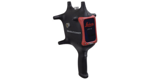
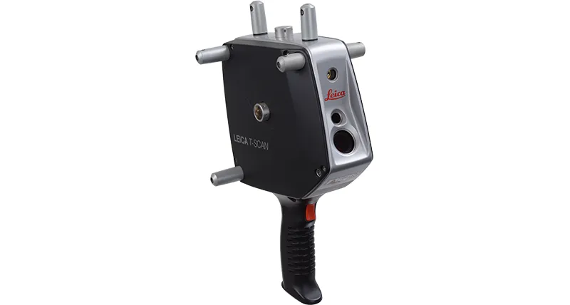
Leica T-Scan 5 – The most dynamic laser scanner ever

The Leica Absolute Tracker takes your scanning experience to a new level of excellence in volumes up to 60m (Ø) in a single set-up. Leica T-Scan 5 is more than 15x faster compared to the previous model and has almost double the stand-off distance, which results in more efficient data capture especially in difficult to reach areas.

The combination of Leica T-Scan 5 and Leica Absolute Tracker offers the perfect match to ensure hundreds of millions of accurate points on virtually any surface, from matte black to highly reflective, even carbon fiber all without any special preparation.

The higher scan rates allow ideal feature recognition, smaller detail detection and much quicker scanning at an approved quality level on all surfaces and colours. The users scanning experience is enhanced with a dual colour guide light and acoustic feed-back. Leica T-Scan 5 is also best qualified for automation and robotic applications, where inspection processes can benefit from maximum laser tracking and machine performance.

SKU: Leica T-Scan 5 Category:

Description

Features

Highest point density Detecting smaller details and getting your scanning results much faster are the main advantages of Leica T-Scan’s new high point density feature. The higher lines and scan rates allow ideal feature recognition and a much quicker scanning at approved quality levels. With up to 160 lines per second or up to 210,000 points per second (210 kHz sampling rate), Leica T-Scan 5 is more than 15x faster compared to the previous model.

Ultra High Dynamic Range The T-Scan 5 can automatically detect very fine differences on any surface type or colour. This allows the operator to pay attention to the part being scanned, not the scanner settings required to scan the different surface types.

Enhanced usability The almost doubled stand-off distance and wider scan line allows more efficient data capture especially in difficult to reach areas with less effort. Hidden features and deep recesses are easier to cover than ever before. Leica T-Scan 5 new user feedback with improved dual-colour pilot beam and acoustic feedback offers most reliable data acquisition and superb user-experience.

Optimized for automation With the fastest data capture rate ever, new cable design and improved robustness, the new Leica T-Scan 5 provides time demanding production processes the ultimate benefit. It has been designed from the ground up to take full advantage of our most dynamic laser tracker performance and advancing robotic speeds in fully automated installations.

Simplicity at its best With no need of object preparation, the Leica T-Scan 5 system has never been as simple to install or use. The small lightweight controller needs neither configuration nor complicated cabling to connect.

Brand

Leica Geosystems

Leica Geosystems Saudi Arabia – Precision Meets Innovation

Introduction

Leica Geosystems Saudi Arabia delivers unmatched precision, durability, and advanced geospatial performance for professionals across construction, infrastructure, mining, and agriculture. For over 200 years, Leica has pioneered surveying instruments, GNSS/GPS systems, laser scanners, and software platforms that empower projects worldwide.

Trusted Worldwide, Available Locally in Saudi Arabia

Founded in Switzerland, Leica Geosystems has built a legacy of engineering excellence. Now available in Saudi Arabia through authorized dealers, Leica Geosystems Saudi Arabia products are adapted for the region’s challenging environments—providing local support, training, and calibrated precision.

Innovation in Every Leica Geosystems Product

Ranging from sophisticated total stations and GNSS receivers to mobile mapping and high-definition laser scanners, Leica Geosystems Saudi Arabia offers real-time accuracy and seamless digital workflows that boost project efficiency and reduce field downtime.

Key Achievements & Milestones

  • Over 200 years of geomatics innovation

  • Inventor of the world’s first digital level and early laser distance meters

  • Reality capture systems deployed in 100+ countries

  • Trusted in major infrastructure, metro, and oil & gas surveying

  • Adopted by engineers, surveyors, and government agencies worldwide

Why Choose Leica Geosystems in Saudi Arabia?

  • Localized support: Technical assistance, training, and product availability through authorized dealers

  • Unmatched accuracy: Instruments deliver centimeter-level precision and durability

  • Comprehensive portfolio: Full range from DISTO distance meters to robotic total stations and reality capture systems

  • Smart integration: Compatible with Hexagon, Autodesk, and other industry-leading software platforms

Leica Product Range in KSA

  • Total Stations – Manual and robotic total stations for construction and high-precision surveying.

  • Mobile Mapping Systems – Pegasus TRK Neo, Pegasus:Backpack, BLK2GO for vehicle, wearable, and handheld 3D capture

  • GPS & GNSS Equipment – GS18 I GNSS RTK rover, iCON GPS smart antennas offering tilt-compensated precision positioning

  • Ground Penetrating Radar (GPR) – Leica GPR solutions for accurate subsurface mapping

  • Laser Scanners – ScanStation P‑Series, RTC360, BLK360, and BLK2FLY for HD 3D scanning and digital twin workflows

  • DISTO Laser Distance Meters & Levels – Leica DISTO™ meter series and LINO/Rugby laser levels for point‑to‑point measurements and leveling

Leica Cyclone Software Portfolio

  • Cyclone REGISTER 360 PLUS – Guided workflows to register and visualize point cloud datasets with automation for efficient office workflows

  • Cyclone 3DR – End-to-end solution to analyze and model point clouds into actionable 3D deliverables

  • Cyclone Enterprise – On‑premise project and data management platform for centralized reality capture workflows

  • Cyclone Cloud – Subscription-based SaaS portal offering centralized license management and secure cloud-hosted service access

Get in Touch - Contact Us

Discover how Leica Geosystems Saudi Arabia solutions can elevate your next project. Reach out to your authorized local distributor to request demos, pricing, and expert consultation tailored to your requirements.

Official Website: www.leica-geosystems.com

Leica Geosystems is a world leader in precision surveying and geospatial solutions with over 200 years of expertise. From total stations and GNSS/GPS receivers to 3D laser scanning systems, Leica products deliver exceptional accuracy and reliability for construction, infrastructure, and mapping projects in Saudi Arabia and worldwide.

Reviews

There are no reviews yet.

Only logged in customers who have purchased this product may leave a review.

Title

Go to Top