Leica Absolute Tracker AT930

Contact Details

3D portable laser tracker with high-speed dynamics as standard

The Leica Absolute Tracker AT930 is the next generation 3D laser tracker to feature the Leica Absolute Interferometer (AIFM), giving high-speed dynamic measurement capabilities that set it apart from the competition. With automatic target location, real-time architecture and the ability to instantly re-establish an interrupted beam, it is the fast, accurate and user-friendly way to measure to reflectors.
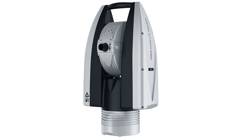
Certified to IP54 standards by the IEC, the AT930’s robust integrated-technology design is ready to measure in even the harshest conditions with no need for additional accessories.

As the 3D version of the Leica Absolute Tracker AT960, the AT930 shares all the AT960’s features and functionality except for the variozoom 6DoF compatibility, making it the ideal solution for high-speed measurements in volumes of up to 160 m (Ø). Compatible with reflectors for line of sight measurement, the AT930 offers a versatile portable 3D laser tracker solution.The latest generation of the PowerLock active vision system ensures that the laser automatically follows the user, re-establishing an interrupted beam with a typical uncertainty of just 10 µm, so operators no longer need to worry about breaking the beam. The AIFM provides the measurement speed of an interferometer and the accuracy of an absolute distance meter, while the real-time operating system supports a measurement rate of up to 1 000 points per second.

The all-in-one design with levelling equipment, environmental monitoring and overview camera all built into the device enables users to simply unpack the tracker and start to measure. Also featuring wireless communication and a choice of mains power or battery option, the AT930 can operate virtually anywhere.

SKU: Leica Absolute Tracker AT930 Category:

Description

Features

All-in-one design
With every Leica laser tracker accessory built in to the device, the AT930 requires minimal setup and operator training, and can be ready to measure straight from the box.

PowerLock
Interrupted line of sight is automatically re-established in a +/-5 degree field of view with no user interaction required for ease of use and exceptional performance in even the most crowded measurement volumes.

Absolute Interferometer (AIFM)
The AIFM single distancing unit combines the accuracy of an absolute distance meter and the speed of an interferometer to give readings quickly and accurately with no need for a home point.

1 kHz data output
Real-time architecture with dynamic performance gives a measurement rate of up to 1 000 points per second, enabling more detailed data capture, more quickly.

Battery power
Independent hot-swap battery power supply allows a quick and easy cable-free setup in almost any location for better portability, offering a flexible solution that lasts up to a day’s shift – wherever the tracker is needed.

Wi-Fi
Built-in Wi-Fi enables simple setup and communication with the PC for truly wireless operations, also providing remote control options via laptops, tablets or smartphones so the tracker can be operated by a single user.

IP54
The IEC-certified sealed unit guarantees ingress protection against dust and other contaminants, enabling the tracker to measure effectively in even the harshest environments.

MeteoStation
Integrated environmental unit monitors conditions including temperature, pressure and humidity to compensate for changes and ensure accurate measurements regardless of external factors.

Overview camera (OVC)
High-resolution colour OVC enables operators to remotely view the tracker’s field of vision, locating targets to measure to fixed reflectors – including multi-spot handling in a single image – ideal for static hidden point devices or to supplement documentation.

Orient to gravity (OTG)
The OTG function enables users to measure with the Z-axis aligned to gravity, ideal for levelling and alignment tasks such as build and inspect of tool and jig fixturing.

Brand

Leica Geosystems

Leica Geosystems Saudi Arabia – Precision Meets Innovation

Introduction

Leica Geosystems Saudi Arabia delivers unmatched precision, durability, and advanced geospatial performance for professionals across construction, infrastructure, mining, and agriculture. For over 200 years, Leica has pioneered surveying instruments, GNSS/GPS systems, laser scanners, and software platforms that empower projects worldwide.

Trusted Worldwide, Available Locally in Saudi Arabia

Founded in Switzerland, Leica Geosystems has built a legacy of engineering excellence. Now available in Saudi Arabia through authorized dealers, Leica Geosystems Saudi Arabia products are adapted for the region’s challenging environments—providing local support, training, and calibrated precision.

Innovation in Every Leica Geosystems Product

Ranging from sophisticated total stations and GNSS receivers to mobile mapping and high-definition laser scanners, Leica Geosystems Saudi Arabia offers real-time accuracy and seamless digital workflows that boost project efficiency and reduce field downtime.

Key Achievements & Milestones

  • Over 200 years of geomatics innovation

  • Inventor of the world’s first digital level and early laser distance meters

  • Reality capture systems deployed in 100+ countries

  • Trusted in major infrastructure, metro, and oil & gas surveying

  • Adopted by engineers, surveyors, and government agencies worldwide

Why Choose Leica Geosystems in Saudi Arabia?

  • Localized support: Technical assistance, training, and product availability through authorized dealers

  • Unmatched accuracy: Instruments deliver centimeter-level precision and durability

  • Comprehensive portfolio: Full range from DISTO distance meters to robotic total stations and reality capture systems

  • Smart integration: Compatible with Hexagon, Autodesk, and other industry-leading software platforms

Leica Product Range in KSA

  • Total Stations – Manual and robotic total stations for construction and high-precision surveying.

  • Mobile Mapping Systems – Pegasus TRK Neo, Pegasus:Backpack, BLK2GO for vehicle, wearable, and handheld 3D capture

  • GPS & GNSS Equipment – GS18 I GNSS RTK rover, iCON GPS smart antennas offering tilt-compensated precision positioning

  • Ground Penetrating Radar (GPR) – Leica GPR solutions for accurate subsurface mapping

  • Laser Scanners – ScanStation P‑Series, RTC360, BLK360, and BLK2FLY for HD 3D scanning and digital twin workflows

  • DISTO Laser Distance Meters & Levels – Leica DISTO™ meter series and LINO/Rugby laser levels for point‑to‑point measurements and leveling

Leica Cyclone Software Portfolio

  • Cyclone REGISTER 360 PLUS – Guided workflows to register and visualize point cloud datasets with automation for efficient office workflows

  • Cyclone 3DR – End-to-end solution to analyze and model point clouds into actionable 3D deliverables

  • Cyclone Enterprise – On‑premise project and data management platform for centralized reality capture workflows

  • Cyclone Cloud – Subscription-based SaaS portal offering centralized license management and secure cloud-hosted service access

Get in Touch - Contact Us

Discover how Leica Geosystems Saudi Arabia solutions can elevate your next project. Reach out to your authorized local distributor to request demos, pricing, and expert consultation tailored to your requirements.

Official Website: www.leica-geosystems.com

Leica Geosystems is a world leader in precision surveying and geospatial solutions with over 200 years of expertise. From total stations and GNSS/GPS receivers to 3D laser scanning systems, Leica products deliver exceptional accuracy and reliability for construction, infrastructure, and mapping projects in Saudi Arabia and worldwide.

Reviews

There are no reviews yet.

Only logged in customers who have purchased this product may leave a review.

Title

Go to Top