Leica Disto D2 Laser Distance Meter

Contact Details

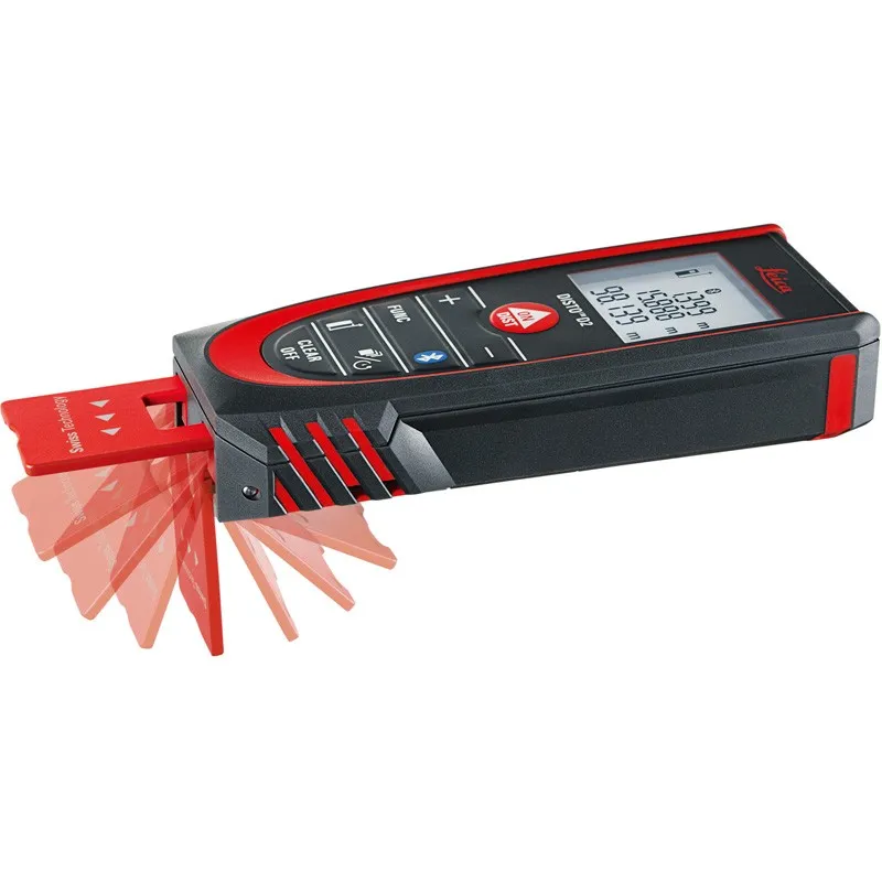
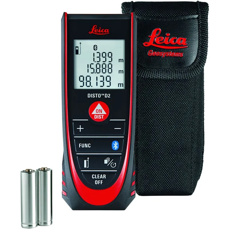
Compact laser distance meter with Bluetooth® Smart and multifunctional end-piece

The smallest laser distance measurer in the Disto range, the Leica DISTO D2 is versatile and ideal for use indoors. The Disto D2 has easy to use keys for subtraction, addition, volume and area calculations. The D2 is very compact, ergonomic and handy making it a capable tool, especially for its size.

Benefits & functions of the Leica DISTO D2

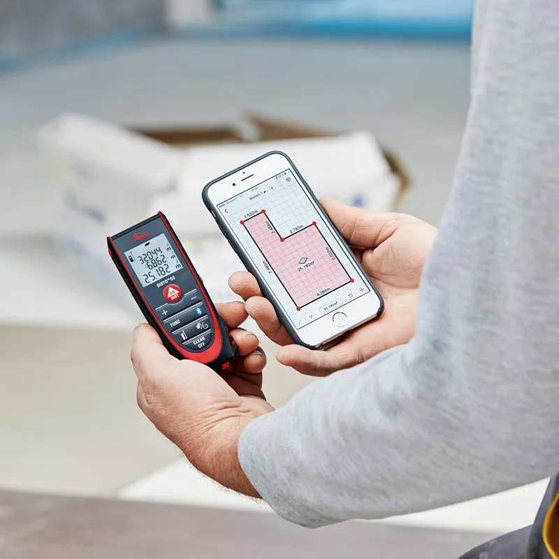
  • Bluetooth Smart (4.0)
  • Easy and fast – The Leica DISTO D2 gives measurements at the press of a single button.
  • Measure areas and volumes
  • Excellent Memory – The last 10 results are kept for fast access.
  • Compact – Thanks to its ergonomic and small and includes a soft grip. Leica DISTO D2 fits nicely in your hand and into any pocket.
  • Easy to read display – Measurements are shown on a 3-line illuminated display, readable in the dark.
  • Min / max results, tracking and storage makes your work much easier.
  • Shortcut keys – Easy-to-use for frequently used functions
  • Flip-out end-piece – For measuring from edges or corners
  • Protected to IP54 – Dust and splash proof
  • Pythagorean functions – Indirect width and height measurements for inaccessible positions
  • Delayed time – Measure without shake
  • Painter Function
  • Stake Out Function
  • Intelligent Endpiece

Package includes:

  • Leica Disto D2 laser distance meter
  • Disto Holster
  • Secure hand loop
  • Batteries


SKU: 837031 Categories: ,

Description

The latest version of the popular Disto D2 comes with Bluetooth™, an integrated intelligent endpiece, a clear bright white display and an ISO certified measuring engine that drives 1/16″ accuracy and 330 foot measuring range.

The Leica DISTO™ D2 is a 7 measurement method LDM accurate to 1/16 of an inch. It features an intuitive back-lit LCD display in a 4oz package that is small enough to fit in your pocket.

Use Bluetooth™ connectivity to transmit measurements into apps running on mobile devices such as the iPad, iPhone, Nexus 7 and Sony Z1.

The Disto D2 measures from its base as standard and can be arranged to measure from the front.

Flip out the endpiece to 90º to catch onto outside corners or lengthen the endpiece fully for inside corners. Along with the Min/Max function, the Disto endpiece allows you to get the instrument all the way into the corners for precise diagonal measurements.

The D2 calculates both area and volume, and retains the last 10 measurements taken in its memory. Make use of the Add/Subtract capability to join measurements to get a accurate reading of the total wall area of a room (also known as “the painter function”).

Technical Specifications
Typical measuring accuracy 1/16”
ISO 16331-1 certified Range up to 100 Metres
Measuring units 0.000 m, 0.00 ft, 0'00" 1/16, 0 in 1/16
Memory Last 10 values
Data Interface Bluetooth Smart V4.0
Measurements per set of batteries up to 10,000
Multifunctional end-piece Yes, Intelligent recognition
Batteries 2x AAA 1.5 V (Ships with alkaline)
Display 3 line display with illumination
Protection class IP54, dust-proof, splash-proof
Dimensions 4.57 x 1.73 x 1.02 in
Weight with batteries 3.53 oz
Minimum / maximum measurements Yes
Area / volume calculation Yes
Pythagoras functions 2 points, 3 points
Stake-out function Yes, single value
Painter Function Yes
Subtraction / addition Yes
Timer function Yes, variable
Beep Yes, switchable on/off
Operating temperature range 14°F to 122°F
Storage temperature range -13°F to 158°F

Brand

Leica Geosystems

Leica Geosystems Saudi Arabia – Precision Meets Innovation

Introduction

Leica Geosystems Saudi Arabia delivers unmatched precision, durability, and advanced geospatial performance for professionals across construction, infrastructure, mining, and agriculture. For over 200 years, Leica has pioneered surveying instruments, GNSS/GPS systems, laser scanners, and software platforms that empower projects worldwide.

Trusted Worldwide, Available Locally in Saudi Arabia

Founded in Switzerland, Leica Geosystems has built a legacy of engineering excellence. Now available in Saudi Arabia through authorized dealers, Leica Geosystems Saudi Arabia products are adapted for the region’s challenging environments—providing local support, training, and calibrated precision.

Innovation in Every Leica Geosystems Product

Ranging from sophisticated total stations and GNSS receivers to mobile mapping and high-definition laser scanners, Leica Geosystems Saudi Arabia offers real-time accuracy and seamless digital workflows that boost project efficiency and reduce field downtime.

Key Achievements & Milestones

  • Over 200 years of geomatics innovation

  • Inventor of the world’s first digital level and early laser distance meters

  • Reality capture systems deployed in 100+ countries

  • Trusted in major infrastructure, metro, and oil & gas surveying

  • Adopted by engineers, surveyors, and government agencies worldwide

Why Choose Leica Geosystems in Saudi Arabia?

  • Localized support: Technical assistance, training, and product availability through authorized dealers

  • Unmatched accuracy: Instruments deliver centimeter-level precision and durability

  • Comprehensive portfolio: Full range from DISTO distance meters to robotic total stations and reality capture systems

  • Smart integration: Compatible with Hexagon, Autodesk, and other industry-leading software platforms

Leica Product Range in KSA

  • Total Stations – Manual and robotic total stations for construction and high-precision surveying.

  • Mobile Mapping Systems – Pegasus TRK Neo, Pegasus:Backpack, BLK2GO for vehicle, wearable, and handheld 3D capture

  • GPS & GNSS Equipment – GS18 I GNSS RTK rover, iCON GPS smart antennas offering tilt-compensated precision positioning

  • Ground Penetrating Radar (GPR) – Leica GPR solutions for accurate subsurface mapping

  • Laser Scanners – ScanStation P‑Series, RTC360, BLK360, and BLK2FLY for HD 3D scanning and digital twin workflows

  • DISTO Laser Distance Meters & Levels – Leica DISTO™ meter series and LINO/Rugby laser levels for point‑to‑point measurements and leveling

Leica Cyclone Software Portfolio

  • Cyclone REGISTER 360 PLUS – Guided workflows to register and visualize point cloud datasets with automation for efficient office workflows

  • Cyclone 3DR – End-to-end solution to analyze and model point clouds into actionable 3D deliverables

  • Cyclone Enterprise – On‑premise project and data management platform for centralized reality capture workflows

  • Cyclone Cloud – Subscription-based SaaS portal offering centralized license management and secure cloud-hosted service access

Get in Touch - Contact Us

Discover how Leica Geosystems Saudi Arabia solutions can elevate your next project. Reach out to your authorized local distributor to request demos, pricing, and expert consultation tailored to your requirements.

Official Website: www.leica-geosystems.com

Leica Geosystems is a world leader in precision surveying and geospatial solutions with over 200 years of expertise. From total stations and GNSS/GPS receivers to 3D laser scanning systems, Leica products deliver exceptional accuracy and reliability for construction, infrastructure, and mapping projects in Saudi Arabia and worldwide.

Reviews

There are no reviews yet.

Only logged in customers who have purchased this product may leave a review.

Title

Go to Top