Leica Absolute Tracker ATS600

Contact Details

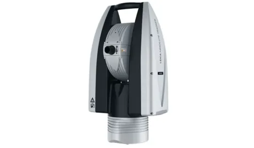
The First Ever Direct Scanning Laser Tracker

Manufacturers are increasingly interested in digitally pinpointing and inspecting large parts and surfaces that are simply out of range of a traditional handheld 3D laser scanner, touch probe or reflector. The Leica Absolute Tracker ATS600 is ready to meet the challenges of these new applications with a unique working principle that can accurately locate a point in 3D space with metrology-grade accuracy without the need for a reflector at the point of measurement.

Based on the established Wave-Form Digitiser technology behind some high-end surveying tools, the ATS600 is powered by the first ever Scanning Absolute Distance Meter, a metrology-grade iteration of this technical principle that can locate a point to within 300 microns from up to 60 metres away.

By measuring a series of such points across a user-definable measurement area, the ATS600 can quickly produce a measurement grid defining the target measurement surface. The density of that point-grid is also customisable, putting the operator in complete control of the balance between process speed and the level of detail that will feed into your metrology software.

With the Leica Absolute Tracker ATS600, objects that previously required significant time investments to digitise, or which were even beyond the realistic possibility of efficient measurement, can be quickly brought into the world of 3D analysis by a single operator. With the world’s first ‘direct scanning laser tracker’, productive quality control is primed to expand into entirely new areas of production, powered by a fundamental shift in the way we think about 3D measurement.

The ATS600 also delivers many of the features familiar from the rest of our Absolute Tracker product range, including reflector measurement at up to 80 metres distance, with full PowerLock capability. Combining reflector measurement and direct scanning capabilities delivers impressive all-round performance for large-scale measurement tasks, with scanning quickly describing surfaces and individual reflector readings used for alignment and defining features.

SKU: Leica Absolute Tracker ATS600 Category:

Description

The Scanning Absolute Distance Meter (ADM)
The first ever Scanning ADM allows the Leica Absolute Tracker ATS600 to accurately locate a point in 3D coordinate space either with or without a reflector, allowing for standard laser tracker single-point measurements alongside the unique ability to digitise a surface from up to 60 metres distance with no target in place at the point of measurement.

Variable Point Density
The point density of the surface measurement grid the ATS600 produces is entirely user configurable, putting the operator in complete control of finding the perfect balance between data quality and process speed.

Selective Scanning
There’s no need for unnecessary measurement with the ATS600 – just define your target measurement area with the integrated Overview Camera or by using CAD data within your software and the system will limit its measurement process to exactly the area required – no need to mess around with parsing the data of a full-dome scan to collect a few degrees-worth of measurement data.

Operator Independence
With no need for a target in place to make a measurement, the Leica Absolute Tracker ATS600 does away with one of the more expensive parts of the typical laser tracker system – the operator at the point of measurement – making the this a laser tracker uniquely suited to automated measurement processes.

Metrology Workflow
With its design as a dedicated metrology device, the ATS600 is as standard fully compatible with all the accepted metrology software packages, allowing it to fit seamlessly alongside currently established metrology workflows and data processing standards.

PowerLock
As with every model within our Absolute Tracker line-up, the ATS600 comes with the renowned PowerLock function as standard when performing reflector measurements, allowing an interrupted line-of-sight to the measurement target to be automatically re-established with no user interaction required.

Combined Measurement
The ATS600 is particularly powerful when using both direct scanning and reflector measurement within the same process, whether that’s quality inspection of large parts using scanning for surfaces and a reflector for features, or build and adjust procedures where scanning provides a complete picture of the assembly and reflector measurement delivers a more accurate position reference.

Battery Power
The expected independent hot-swappable battery power supply is also standard for the ATS600, allowing for quick and easy cable-free setup in almost any location for better portability – ideal for a laser tracker cleared well-suited to use around large-scale worksites.

WiFi Connectivity
The built-in WiFi connectivity of the ATS600 adds to the impressive portability of the system, while also allowing for even easier control of a unit that can fully deliver with just a single operator.

IP54 Certified
The ATS600 is an IP54 IEC-certified sealed unit with guaranteed ingress protection against dust and other contaminants, enabling the laser tracker to measure effectively in even the harshest environments.

MeteoStation
An integrated environmental monitor checks conditions including temperature, pressure and humidity, allowing for the recording of accurate measurements regardless of the challenges of hostile measurement settings.

All-in-One Design
As with all our laser tracker systems, the ATS600 has been built for portability, weighing in at less than 15 kilograms and able to be securely transported within a single small flight case.

Orient to Gravity (OTG)
The OTG function enables users to measure with the Z-axis aligned to gravity, ideal for levelling and alignment tasks such as build and inspect of tool and jig fixturing.

Brand

Leica Geosystems

Leica Geosystems Saudi Arabia – Precision Meets Innovation

Introduction

Leica Geosystems Saudi Arabia delivers unmatched precision, durability, and advanced geospatial performance for professionals across construction, infrastructure, mining, and agriculture. For over 200 years, Leica has pioneered surveying instruments, GNSS/GPS systems, laser scanners, and software platforms that empower projects worldwide.

Trusted Worldwide, Available Locally in Saudi Arabia

Founded in Switzerland, Leica Geosystems has built a legacy of engineering excellence. Now available in Saudi Arabia through authorized dealers, Leica Geosystems Saudi Arabia products are adapted for the region’s challenging environments—providing local support, training, and calibrated precision.

Innovation in Every Leica Geosystems Product

Ranging from sophisticated total stations and GNSS receivers to mobile mapping and high-definition laser scanners, Leica Geosystems Saudi Arabia offers real-time accuracy and seamless digital workflows that boost project efficiency and reduce field downtime.

Key Achievements & Milestones

  • Over 200 years of geomatics innovation

  • Inventor of the world’s first digital level and early laser distance meters

  • Reality capture systems deployed in 100+ countries

  • Trusted in major infrastructure, metro, and oil & gas surveying

  • Adopted by engineers, surveyors, and government agencies worldwide

Why Choose Leica Geosystems in Saudi Arabia?

  • Localized support: Technical assistance, training, and product availability through authorized dealers

  • Unmatched accuracy: Instruments deliver centimeter-level precision and durability

  • Comprehensive portfolio: Full range from DISTO distance meters to robotic total stations and reality capture systems

  • Smart integration: Compatible with Hexagon, Autodesk, and other industry-leading software platforms

Leica Product Range in KSA

  • Total Stations – Manual and robotic total stations for construction and high-precision surveying.

  • Mobile Mapping Systems – Pegasus TRK Neo, Pegasus:Backpack, BLK2GO for vehicle, wearable, and handheld 3D capture

  • GPS & GNSS Equipment – GS18 I GNSS RTK rover, iCON GPS smart antennas offering tilt-compensated precision positioning

  • Ground Penetrating Radar (GPR) – Leica GPR solutions for accurate subsurface mapping

  • Laser Scanners – ScanStation P‑Series, RTC360, BLK360, and BLK2FLY for HD 3D scanning and digital twin workflows

  • DISTO Laser Distance Meters & Levels – Leica DISTO™ meter series and LINO/Rugby laser levels for point‑to‑point measurements and leveling

Leica Cyclone Software Portfolio

  • Cyclone REGISTER 360 PLUS – Guided workflows to register and visualize point cloud datasets with automation for efficient office workflows

  • Cyclone 3DR – End-to-end solution to analyze and model point clouds into actionable 3D deliverables

  • Cyclone Enterprise – On‑premise project and data management platform for centralized reality capture workflows

  • Cyclone Cloud – Subscription-based SaaS portal offering centralized license management and secure cloud-hosted service access

Get in Touch - Contact Us

Discover how Leica Geosystems Saudi Arabia solutions can elevate your next project. Reach out to your authorized local distributor to request demos, pricing, and expert consultation tailored to your requirements.

Official Website: www.leica-geosystems.com

Leica Geosystems is a world leader in precision surveying and geospatial solutions with over 200 years of expertise. From total stations and GNSS/GPS receivers to 3D laser scanning systems, Leica products deliver exceptional accuracy and reliability for construction, infrastructure, and mapping projects in Saudi Arabia and worldwide.

Reviews

There are no reviews yet.

Only logged in customers who have purchased this product may leave a review.

Title

Go to Top