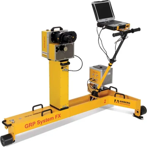
-
The configuration consists of
- Premium hardware GRP 3000
- Application specific software Clearance Basic
- Robust and guaranteed precision thanks to GRP Fidelity
- First-class application support
Amberg Clearance
Modular system solution for automatic clearance surveying completed by typical railway analyses and documentation.
Project data management
- Central database for input, visualisation and management of clearance envelopes, clearance models, track project data including route data chronology, control points and measuring epochs.
- Flexible and user friendly clearance envelope editor.
- Provision of all clearance specifications for subsequent surveying tasks and evaluations.
Surveying
- Profile measurements in 2D clearance mode or 3D coordinate mode with combined capturing of all relevant track geometry data (stationing, gauge, superelevation, 3D track coordinates (with TPS, GPS only)).
- Profile data collection:
- - Either with manual object point targeting.
- - Or automatic profile measurement with definable point density on the object surface.
- Display of profile distances between measured object and selected theoretical clearance envelope in real-time directly on site.
Evaluation
- Complete surveyed data management including automatic incorporation of subsequent re-measurements.
- Fully automatic evaluation by comparing clearance surveys with a predefined clearance model for given section – either relative to the current track position or (for 3D data) in terms of a predefined, theoretical track position.
- Comprehensive, automatic reporting.
- - Profile plot including clearance distances.
- - Coordinate list with additional gauging information.
- Established interfaces to third party clearance and design applications like DXF, ASCII, SC0 (ClearRoute), LUE (Lira).
-
The configuration consists of
- Premium hardware GRP 5000
- Application specific software Clearance Plus
- Robust and guaranteed precision thanks to GRP Fidelity
- First-class application support
-
The configuration consists of
- Premium hardware GRP 5000
- Application specific software Clearance Plus
- Robust and guaranteed precision thanks to GRP Fidelity
- First-class application support
-
Complete railway infrastructure data in no time – simple and high performant
The new way of railway infrastructure scanning
- Well-tried GRP 5000 system enhanced with IMU technology
- Combined survey of relative and absolute track geometry
- Comprehensive scan data for clearance analysis and design purposes
- Highly accurate 3D point cloud of complete infrastructure
- Unrivalled survey performance up to 4,000 m/h
- No total station or GNSS signal required for absolute data
Modular system design
- Measuring trolley consisting of precision sensors for gauge, superelevation and distance as well as ruggedized notebook
- Laserscanner Amberg Profiler 6012 for acquisition of complete infrastructure
- AMU 1030 (Amberg Measuring Unit) for unrivalled kinematic measurement precision
- Modular system upgrading possibilities
Absolute as-built track and infrastructure survey with given 3D control points
- High performance for short and long track sections – up to 4,000 m/h
- Absolute 3D control points as transformation references
- Switching on / off control points for processing depending on quality
- Unlimited use during day and night – no line of sight requirements
Relative track geometry and infrastructure survey
- Pure relative survey of track geometry and objects around track
- Stationing plates as references
- Measurement and calculation of track parameters like horizontal / vertical versines, curvature / radius, gauge, superelevation and twist
- Usage of these parameters e.g. for dynamic clearance analysis
Speedy and conclusive clearance assessments with real-time results
Modular system solution for manual and automatic clearance survey including sophisticated engine for static and dynamic clearance analysis
One software package with scalable functionality (Basic and Plus)
Powerful management of project data including static and dynamic clearance models
Comprehensive and high-resolution data acquisition to detect every potentially critical object
Clearance analysis results in real-time
Powerful evaluation, analysis, reporting and exporting tools optimised for the typical requirements
Measurement system
Scalable measurement system from quick and easy single object point measurement to high-resolution scanning
Data acquisition in relative or absolute mode
Display of relevant clearance information in real-time on measurement screen
System configurations: GRP 3000, GRP 5000, IMS 5000
Software
Management of user-definable static clearance models or integrated dynamic clearance models
Post-processing of high-resolution clearance results for complete point clouds
Clearance map for detailed documentation of clearance encroachments over a complete section of track
Various report and export formats containing profile or point cloud data