Leica Pegasus TRK NEO

Contact Details

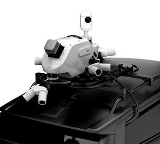
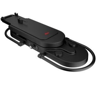
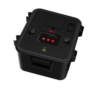
The Leica Pegasus TRK NEO is a cutting-edge, vehicle-mounted mobile mapping system designed for large-scale, high-precision 3D geospatial data collection. Ideal for smart city development, road networks, and infrastructure mapping across Saudi Arabia.

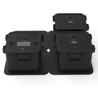
The Leica Pegasus TRK NEO is a premium mobile mapping system engineered for professionals demanding ultra-high accuracy, extended range, and maximum scalability. Designed for nationwide infrastructure mapping, digital twin creation, and smart city modeling, it delivers survey-grade 3D point clouds, panoramic imaging, and integrated GNSS/IMU data in a fully automated workflow.

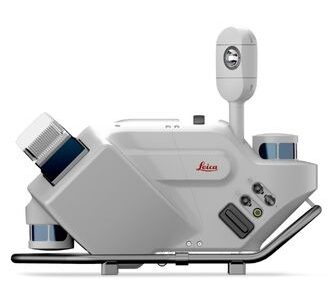
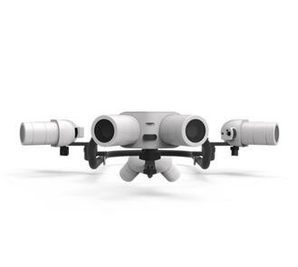
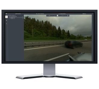
Equipped with dual laser scanners and AI-enhanced object recognition, the TRK NEO captures dense data at highway speeds with minimal human input. The system is fully compatible with Leica Pegasus software and cloud tools for fast processing and collaboration.

Built for the demands of government, utilities, transportation, and large-scale development projects across Saudi Arabia, the TRK NEO is supported by SITML, your certified Leica Geosystems mobile mapping distributor and service center in KSA.

SKU: Leica Pegasus TRK NEO Category:

Description

Flexible, Long-Range Mobile Mapping for Detailed Digital Twins and Immersive 3D Insights

The Leica Pegasus TRK Neo is a powerful and adaptable mobile mapping solution engineered to deliver precise geospatial data with user-friendly operation. Featuring an impressive maximum range of 730 meters—the longest in the Pegasus TRK lineup—it captures highly detailed, immersive datasets ideal for applications like smart city planning, environmental assessments, mining site surveys, and large-scale infrastructure projects.

Offered in two configurations—Pegasus TRK500 (single-head) and TRK700 (dual-head)—the system captures up to 4 million points per second, making it exceptionally effective for collecting complex, high-resolution data. Its quick-mount design and efficient deployment process enable professionals to begin scanning with minimal setup, while its rugged construction ensures dependable use in harsh field conditions.

Fully integrated with Leica Pegasus FIELD and OFFICE, the TRK Neo supports a seamless workflow from field acquisition to final output. RTK-enabled positioning allows for real-time processing and immediate data export, reducing project turnaround and improving operational productivity. Built-in real-time anonymization ensures that privacy regulations are automatically met without additional effort.

Optimized for long-range mapping and detailed point cloud generation, the Pegasus TRK Neo offers the performance and flexibility required for advanced mobile mapping projects where both accuracy and range are critical.

Leica Pegasus TRK500 Neo

The Pegasus TRK500 Neo is a highly efficient single-head mobile mapping system that captures up to 2 million points per second using a precise single-line scan pattern—ideal for comprehensive, high-quality geospatial mapping across a wide range of applications.

Leica Pegasus TRK700 Neo

The Pegasus TRK700 Neo features a dual-scanner setup that captures up to 4 million points per second using a crossed-line scan pattern. This configuration delivers high-density point clouds and exceptional detail, making it ideal for complex and large-scale mapping projects.

Discover the Leica Pegasus TRK Neo Mobile Mapping System

Real-world applications

Smart City Modeling

Combining extended range, long battery life, and advanced imaging capabilities, the Pegasus TRK Neo is purpose-built for mapping expansive urban areas. It supports strategic initiatives in urban planning, development, and sustainability efforts through comprehensive data capture.

Environmental Monitoring

Designed for frequent, high-resolution capture, the Pegasus TRK Neo is ideal for observing land-use evolution, analyzing terrain conditions, and conducting flood risk assessments and environmental impact studies over time.

HD Mapping

The Pegasus TRK Neo collects precise road and infrastructure data used to create high-definition datasets for 3D simulation, advanced mapping, and autonomous vehicle base map generation in large-scale digital environments.

Road Infrastructure Surveys

The Pegasus TRK Neo delivers detailed geospatial data for roadway projects, supporting pre-construction assessments, construction progress tracking, and pavement condition evaluations to inform long-term maintenance strategies.

Mining Site Surveys

Designed for demanding environments, the Pegasus TRK Neo captures precise data to support mining operations, including terrain mapping, resource optimization, and compliance with safety standards.

Brand

Leica Geosystems

Leica Geosystems Saudi Arabia – Precision Meets Innovation

Introduction

Leica Geosystems Saudi Arabia delivers unmatched precision, durability, and advanced geospatial performance for professionals across construction, infrastructure, mining, and agriculture. For over 200 years, Leica has pioneered surveying instruments, GNSS/GPS systems, laser scanners, and software platforms that empower projects worldwide.

Trusted Worldwide, Available Locally in Saudi Arabia

Founded in Switzerland, Leica Geosystems has built a legacy of engineering excellence. Now available in Saudi Arabia through authorized dealers, Leica Geosystems Saudi Arabia products are adapted for the region’s challenging environments—providing local support, training, and calibrated precision.

Innovation in Every Leica Geosystems Product

Ranging from sophisticated total stations and GNSS receivers to mobile mapping and high-definition laser scanners, Leica Geosystems Saudi Arabia offers real-time accuracy and seamless digital workflows that boost project efficiency and reduce field downtime.

Key Achievements & Milestones

  • Over 200 years of geomatics innovation

  • Inventor of the world’s first digital level and early laser distance meters

  • Reality capture systems deployed in 100+ countries

  • Trusted in major infrastructure, metro, and oil & gas surveying

  • Adopted by engineers, surveyors, and government agencies worldwide

Why Choose Leica Geosystems in Saudi Arabia?

  • Localized support: Technical assistance, training, and product availability through authorized dealers

  • Unmatched accuracy: Instruments deliver centimeter-level precision and durability

  • Comprehensive portfolio: Full range from DISTO distance meters to robotic total stations and reality capture systems

  • Smart integration: Compatible with Hexagon, Autodesk, and other industry-leading software platforms

Leica Product Range in KSA

  • Total Stations – Manual and robotic total stations for construction and high-precision surveying.

  • Mobile Mapping Systems – Pegasus TRK Neo, Pegasus:Backpack, BLK2GO for vehicle, wearable, and handheld 3D capture

  • GPS & GNSS Equipment – GS18 I GNSS RTK rover, iCON GPS smart antennas offering tilt-compensated precision positioning

  • Ground Penetrating Radar (GPR) – Leica GPR solutions for accurate subsurface mapping

  • Laser Scanners – ScanStation P‑Series, RTC360, BLK360, and BLK2FLY for HD 3D scanning and digital twin workflows

  • DISTO Laser Distance Meters & Levels – Leica DISTO™ meter series and LINO/Rugby laser levels for point‑to‑point measurements and leveling

Leica Cyclone Software Portfolio

  • Cyclone REGISTER 360 PLUS – Guided workflows to register and visualize point cloud datasets with automation for efficient office workflows

  • Cyclone 3DR – End-to-end solution to analyze and model point clouds into actionable 3D deliverables

  • Cyclone Enterprise – On‑premise project and data management platform for centralized reality capture workflows

  • Cyclone Cloud – Subscription-based SaaS portal offering centralized license management and secure cloud-hosted service access

Get in Touch - Contact Us

Discover how Leica Geosystems Saudi Arabia solutions can elevate your next project. Reach out to your authorized local distributor to request demos, pricing, and expert consultation tailored to your requirements.

Official Website: www.leica-geosystems.com

Leica Geosystems is a world leader in precision surveying and geospatial solutions with over 200 years of expertise. From total stations and GNSS/GPS receivers to 3D laser scanning systems, Leica products deliver exceptional accuracy and reliability for construction, infrastructure, and mapping projects in Saudi Arabia and worldwide.

Reviews

There are no reviews yet.

Only logged in customers who have purchased this product may leave a review.

Title

Go to Top