Leica TS13 Full Robotic Package

Contact Details

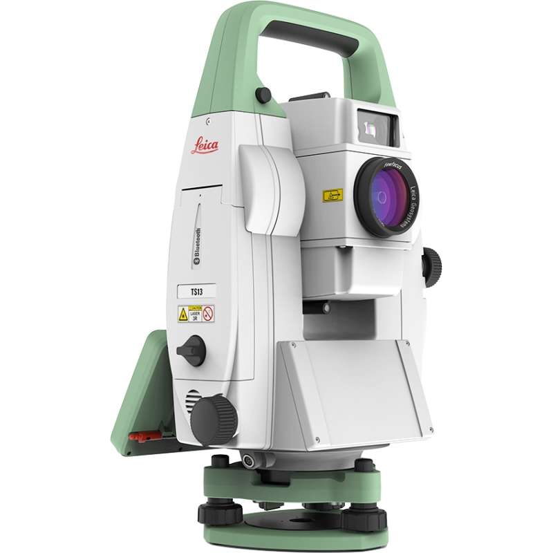
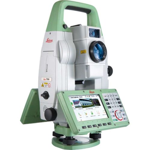
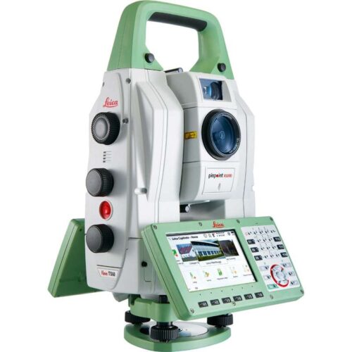
The Leica TS13 total station provides a fast, reliable and efficient solution tailored to the users needs to measure and layout more points. Equipped with Automatic Target Recognition (ATR) technology and optionally with target lock and SpeedSearch to find and lock on to prisms quickly, it provides accurate measuring to targets. Combined with Leica Captivate field software, the TS13 offers a simple and productive way of coding and line work.

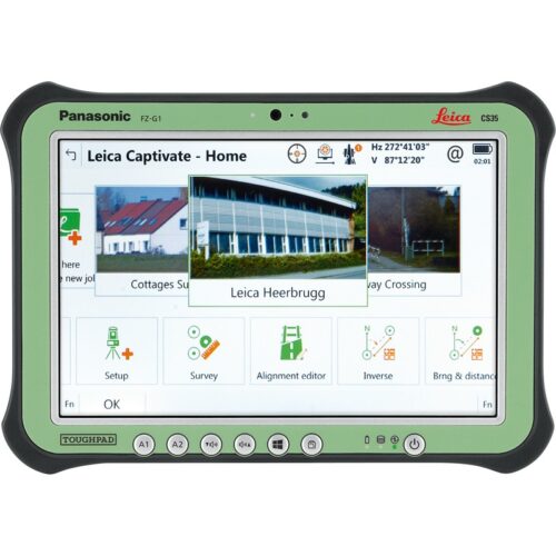
The TS13 works with the revolutionary Leica Captivate field software, turning complex data into the most realistic and workable 3D models. It spans industries and applications with little more than a simple swipe, regardless of whether you work with GNSS, total stations or both. A smooth data transfer ensures the project stays on track. Captivate and Leica Infinity office software work in conjunction to join previous survey data and edit projects faster and more efficiently.
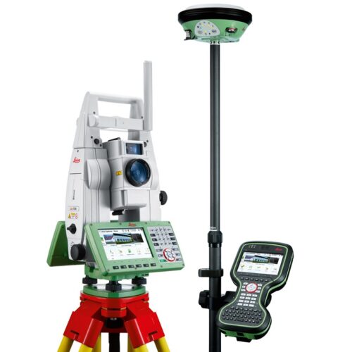
Kit includes:

  • TS13 5″ R500, total station with ATR
  • TOP1, TS13 prism lock option
  • TOP2, TS13 robotic option
  • GDF311 Tribrach without optical plummet
  • GST101 Wooden tripod w/ shoulder strap
  • GLS11 reflector pole
  • Height meter GHM007 with holder GHT196
  • GEB221 Battery int. Li-Ion 7.4V/4400mAh
  • GKL311 single Charger Prof 3000
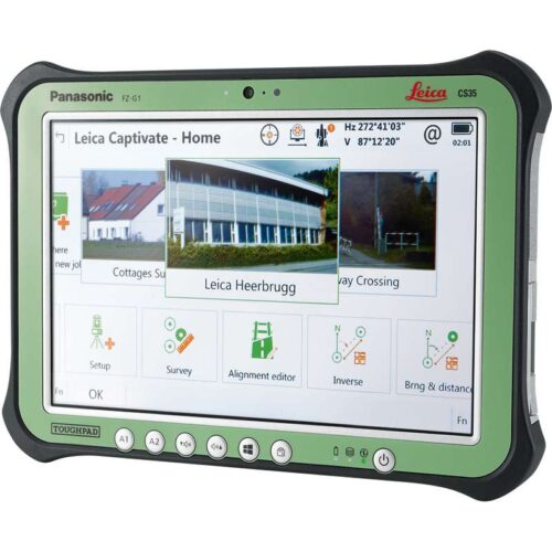
  • CS20 3.75G Field Controller
  • Leica Captivate Measure & Stakeout CS20
  • GEB331 Battery int Li-Ion 11.1V/2800mAh
  • MSD1000, SD memory card 1GB
  • GVP724 TS Robotic Container
  • GRZ4 360° Reflector
  • GHT63 Pole clamp for attaching GHT
  • GHT66 Holder plate for CS20 controller
  • RH17, Bluetooth RadioHandle
  • 1 yr TS13+CS20 Basic CCP
SKU: Leica TS13 Special Offer Category:

Description

Leica TS13 Total Station

Basic variant

Leica TS13 Mid-Range Robotic Total Station

ANGULAR MEASUREMENT
Accuracy 1 Hz and V Absolute, continuous, diametrical 1" (0.3 mgon), 2" (0.6 mgon), 3" (1 mgon), 5" (1.5 mgon)
DISTANCE MEASUREMENT
Range 2 Prism (GPR1, GPH1P) 3
Non-Prism / Any surface 4
1.5 m to 3500 m
R500: 1.5 m to >500 m, R1000: 1.5 m to >1000 m
Accuracy / Measurement time Single (prism) 2,5
Single (any surface) 2,4,5,6
1 mm + 1.5 ppm / Typically 2.4 s
2 mm + 2 ppm / Typically 3 s
Laser dot size At 50 m 8 mm x 20 mm
Measurement technology System analyser Coaxial, visible red laser
AUTOMATIC AIMING - ATR
Target aiming range2 Circular prism (GPR1, GPH1P)
360° prism (GRZ4, GRZ122)
1000 m
800 m
Accuracy 1,2 / Measurement time ATR angle accuracy Hz, V 1" (0.3 mgon), 2" (0.6 mgon), 3" (1 mgon),
5" (1.5 mgon) / Typically 3-4 s
GUIDE LIGHT (EGL)
Working range / Accuracy 5 - 150 m / Typically 5 cm @ 100 m
GENERAL
Processor TI OMAP4430 1GHz Dual-core ARM®
Cortex™ A9 MPCore™
Operating system – Windows® EC7
Power management Exchangeable Lithium-Ion battery Operating time 8 - 10 h
Field software Leica Captivate incl. apps Running on field controller (Leica CS20)
Data storage Internal memory 2 GB
SD card 1 GB or 8 GB
On field controller (Leica CS20)
Interfaces RS232, USB, Bluetooth®, WLAN
Weight Total station including battery 5.0 kg
Environmental specifications Working temperature range
Dust / Water (IEC 60529) / Humidity
–20°C to +50°C
IP55 / 95%, non-condensing
Keyboard Face I standard 4 button keyboard with status LEDs

Upgrades

Leica TS13 Mid-Range Robotic Total Station

KEYBOARD DISPLAY UNIT (Optional)
Keyboard with display Face I and face II optional 5” (inch), WVGA, colour, touch
25 keys, illumination
Power management Exchangeable Lithium-Ion battery Operating time 6 - 8 h
Field software Leica Captivate including apps Running on TS13 instrument
Data storage Internal memory 2 GB
SD card 1 GB or 8 GB
On TS13 instrument
Weight Total station including battery 5.3 kg
TARGET LOCK (Optional)
Target locking range2 Circular prism (GPR1, GPH1P)
360° prism (GRZ4, GRZ122)
800 m
600 m
ROBOTIC SURVEYING including PRISM FAST SEARCH (Optional)
SpeedSearch range / Search time 360° prism (GRZ4, GRZ122) 300 m / Typically 7 s
Robotic range with long-range
Bluetooth® 8
To CS20 internal long-range Bluetooth®
To CTR20 expansion pack
500 m
1000 m

Brand

Leica Geosystems

Leica Geosystems Saudi Arabia – Precision Meets Innovation

Introduction

Leica Geosystems Saudi Arabia delivers unmatched precision, durability, and advanced geospatial performance for professionals across construction, infrastructure, mining, and agriculture. For over 200 years, Leica has pioneered surveying instruments, GNSS/GPS systems, laser scanners, and software platforms that empower projects worldwide.

Trusted Worldwide, Available Locally in Saudi Arabia

Founded in Switzerland, Leica Geosystems has built a legacy of engineering excellence. Now available in Saudi Arabia through authorized dealers, Leica Geosystems Saudi Arabia products are adapted for the region’s challenging environments—providing local support, training, and calibrated precision.

Innovation in Every Leica Geosystems Product

Ranging from sophisticated total stations and GNSS receivers to mobile mapping and high-definition laser scanners, Leica Geosystems Saudi Arabia offers real-time accuracy and seamless digital workflows that boost project efficiency and reduce field downtime.

Key Achievements & Milestones

  • Over 200 years of geomatics innovation

  • Inventor of the world’s first digital level and early laser distance meters

  • Reality capture systems deployed in 100+ countries

  • Trusted in major infrastructure, metro, and oil & gas surveying

  • Adopted by engineers, surveyors, and government agencies worldwide

Why Choose Leica Geosystems in Saudi Arabia?

  • Localized support: Technical assistance, training, and product availability through authorized dealers

  • Unmatched accuracy: Instruments deliver centimeter-level precision and durability

  • Comprehensive portfolio: Full range from DISTO distance meters to robotic total stations and reality capture systems

  • Smart integration: Compatible with Hexagon, Autodesk, and other industry-leading software platforms

Leica Product Range in KSA

  • Total Stations – Manual and robotic total stations for construction and high-precision surveying.

  • Mobile Mapping Systems – Pegasus TRK Neo, Pegasus:Backpack, BLK2GO for vehicle, wearable, and handheld 3D capture

  • GPS & GNSS Equipment – GS18 I GNSS RTK rover, iCON GPS smart antennas offering tilt-compensated precision positioning

  • Ground Penetrating Radar (GPR) – Leica GPR solutions for accurate subsurface mapping

  • Laser Scanners – ScanStation P‑Series, RTC360, BLK360, and BLK2FLY for HD 3D scanning and digital twin workflows

  • DISTO Laser Distance Meters & Levels – Leica DISTO™ meter series and LINO/Rugby laser levels for point‑to‑point measurements and leveling

Leica Cyclone Software Portfolio

  • Cyclone REGISTER 360 PLUS – Guided workflows to register and visualize point cloud datasets with automation for efficient office workflows

  • Cyclone 3DR – End-to-end solution to analyze and model point clouds into actionable 3D deliverables

  • Cyclone Enterprise – On‑premise project and data management platform for centralized reality capture workflows

  • Cyclone Cloud – Subscription-based SaaS portal offering centralized license management and secure cloud-hosted service access

Get in Touch - Contact Us

Discover how Leica Geosystems Saudi Arabia solutions can elevate your next project. Reach out to your authorized local distributor to request demos, pricing, and expert consultation tailored to your requirements.

Official Website: www.leica-geosystems.com

Leica Geosystems is a world leader in precision surveying and geospatial solutions with over 200 years of expertise. From total stations and GNSS/GPS receivers to 3D laser scanning systems, Leica products deliver exceptional accuracy and reliability for construction, infrastructure, and mapping projects in Saudi Arabia and worldwide.

Reviews

There are no reviews yet.

Be the first to review “Leica TS13 Full Robotic Package”

Title

Go to Top