Leica Viva TS16 Total Station

Contact Details

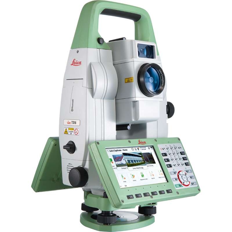
Self-learning in any application

Meet the world’s first self-learning total station. Automatically adjusting to any environmental conditions, the Leica Viva TS16 locks onto your, and only your, target. Regardless of how challenging the task or the amount of distractions in the field, this total station exceeds your expectations.

Cover a wide range of applications when this total station sees precisely what you see. Known for the most comprehensive imaging capability available, you can capture exact conditions for any worksite through the self-learning capability of the Leica Viva TS16.


Engaging software

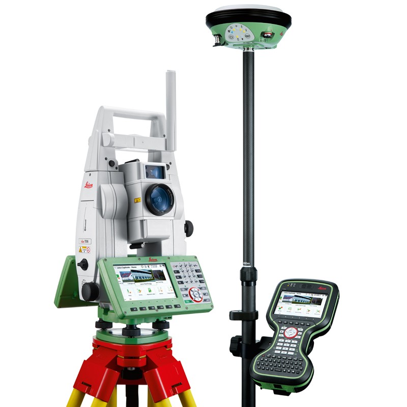
The Leica Viva TS16 total station comes with the revolutionary Captivate software, turning complex data into the most realistic and workable 3D models. With easy-to-use apps and familiar touch technology, all forms of measured and design data can be viewed in all dimensions. Leica Captivate spans industries and applications with little more than a simple swipe, regardless of whether you work with GNSS, total stations or both.

Infinitely bridging the field to the office

While Leica Captivate captures and models data in the field, Leica Infinity processes the information back in the office. A smooth data transfer ensures the project stays on track. Leica Captivate and Leica Infinity work in conjunction to join previous survey data and edit projects faster and more efficiently.

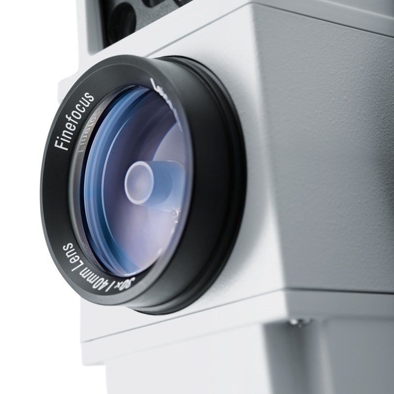
With ATRplus there is only one prism – yours

ATRplus, born from five generations of optimisation, takes known and trusted automation performance to the next level. This superior technology maximises the total station’s ability to remain locked on your target, ignoring other distractions in the field.
The Leica Viva TS16 learns the environment, delivers accurate positions even in difficult dynamic applications, and offers the fastest re-lock in case of interrupted line of sight.

SKU: Leica Viva TS16 Category:

Description

World’s First Self-learning Total Station

  • Automatically and continuously adapts for best measurement performance to site conditions, such as rain, fog, dust, sun, heat shimmer and reflections
  • Identifies and ignores irrelevant targets and reflections

ATRplus With Dominant Performance

  • Automated target aiming range up to 1,500 m
  • Automated target locking range up to 1,000 m
  • Accelerated target search with PowerSearch
  • Robust and highly-accurate position delivery in high dynamic applications

Image Assisted Surveying

  • 5 megapixel wide angle overview camera
  • Video frame rate of up to 20 Hz onboard and remote
  • Automatic panoramic image capture
  • Tap and turn for aiming

Pinpoint R1000 Distance Measurement

  • Single EDM for high accuracy and wide range at the same time
  • Visible measurement beam of small spot size
  • Measurement range on any surface up to 1,000 m

Powered by Leica Captivate

  • Engaging software with immersive experience
  • Full 5“ WVGA display
  • Familiar apps at the simplicity of touch

Brand

Leica Geosystems

Leica Geosystems Saudi Arabia – Precision Meets Innovation

Introduction

Leica Geosystems Saudi Arabia delivers unmatched precision, durability, and advanced geospatial performance for professionals across construction, infrastructure, mining, and agriculture. For over 200 years, Leica has pioneered surveying instruments, GNSS/GPS systems, laser scanners, and software platforms that empower projects worldwide.

Trusted Worldwide, Available Locally in Saudi Arabia

Founded in Switzerland, Leica Geosystems has built a legacy of engineering excellence. Now available in Saudi Arabia through authorized dealers, Leica Geosystems Saudi Arabia products are adapted for the region’s challenging environments—providing local support, training, and calibrated precision.

Innovation in Every Leica Geosystems Product

Ranging from sophisticated total stations and GNSS receivers to mobile mapping and high-definition laser scanners, Leica Geosystems Saudi Arabia offers real-time accuracy and seamless digital workflows that boost project efficiency and reduce field downtime.

Key Achievements & Milestones

  • Over 200 years of geomatics innovation

  • Inventor of the world’s first digital level and early laser distance meters

  • Reality capture systems deployed in 100+ countries

  • Trusted in major infrastructure, metro, and oil & gas surveying

  • Adopted by engineers, surveyors, and government agencies worldwide

Why Choose Leica Geosystems in Saudi Arabia?

  • Localized support: Technical assistance, training, and product availability through authorized dealers

  • Unmatched accuracy: Instruments deliver centimeter-level precision and durability

  • Comprehensive portfolio: Full range from DISTO distance meters to robotic total stations and reality capture systems

  • Smart integration: Compatible with Hexagon, Autodesk, and other industry-leading software platforms

Leica Product Range in KSA

  • Total Stations – Manual and robotic total stations for construction and high-precision surveying.

  • Mobile Mapping Systems – Pegasus TRK Neo, Pegasus:Backpack, BLK2GO for vehicle, wearable, and handheld 3D capture

  • GPS & GNSS Equipment – GS18 I GNSS RTK rover, iCON GPS smart antennas offering tilt-compensated precision positioning

  • Ground Penetrating Radar (GPR) – Leica GPR solutions for accurate subsurface mapping

  • Laser Scanners – ScanStation P‑Series, RTC360, BLK360, and BLK2FLY for HD 3D scanning and digital twin workflows

  • DISTO Laser Distance Meters & Levels – Leica DISTO™ meter series and LINO/Rugby laser levels for point‑to‑point measurements and leveling

Leica Cyclone Software Portfolio

  • Cyclone REGISTER 360 PLUS – Guided workflows to register and visualize point cloud datasets with automation for efficient office workflows

  • Cyclone 3DR – End-to-end solution to analyze and model point clouds into actionable 3D deliverables

  • Cyclone Enterprise – On‑premise project and data management platform for centralized reality capture workflows

  • Cyclone Cloud – Subscription-based SaaS portal offering centralized license management and secure cloud-hosted service access

Get in Touch - Contact Us

Discover how Leica Geosystems Saudi Arabia solutions can elevate your next project. Reach out to your authorized local distributor to request demos, pricing, and expert consultation tailored to your requirements.

Official Website: www.leica-geosystems.com

Leica Geosystems is a world leader in precision surveying and geospatial solutions with over 200 years of expertise. From total stations and GNSS/GPS receivers to 3D laser scanning systems, Leica products deliver exceptional accuracy and reliability for construction, infrastructure, and mapping projects in Saudi Arabia and worldwide.

Reviews

There are no reviews yet.

Be the first to review “Leica Viva TS16 Total Station”

Title

Go to Top