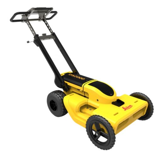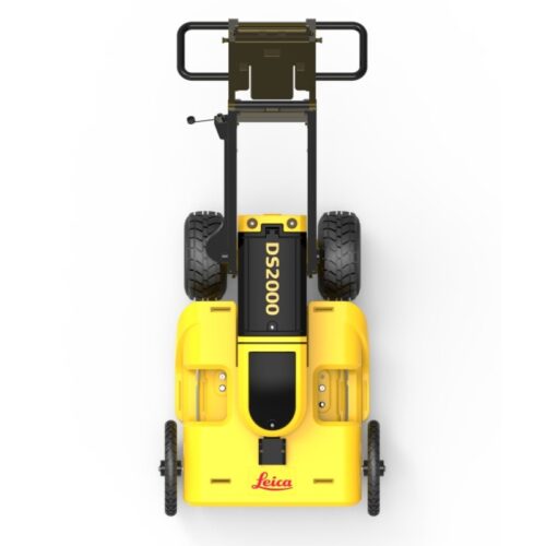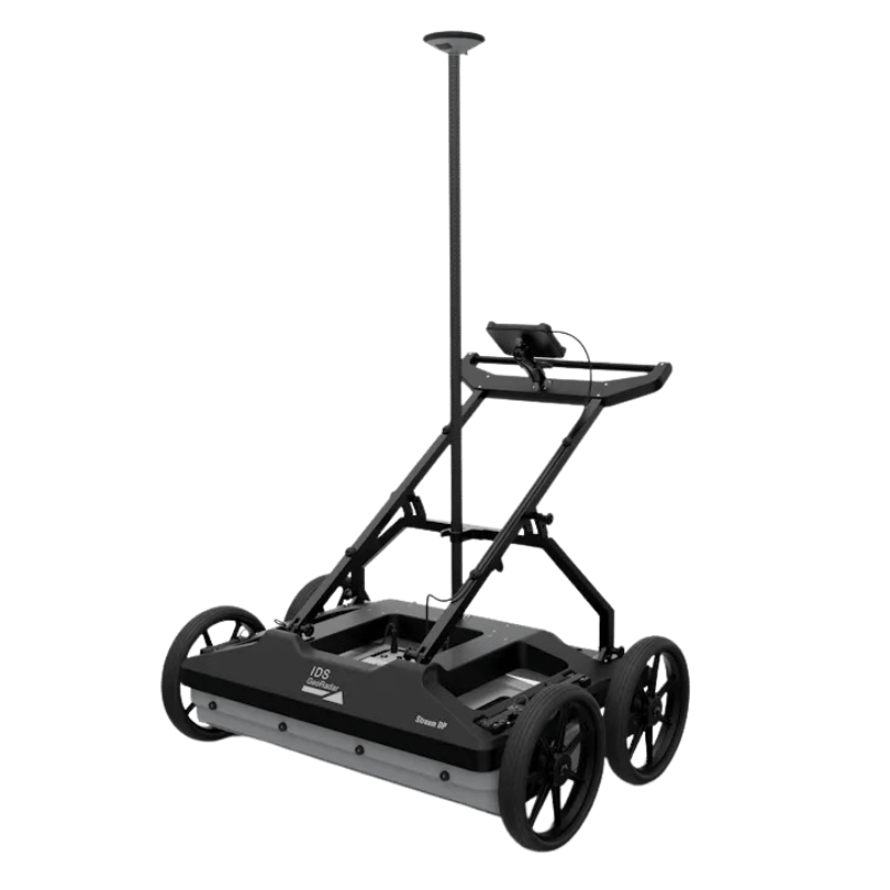
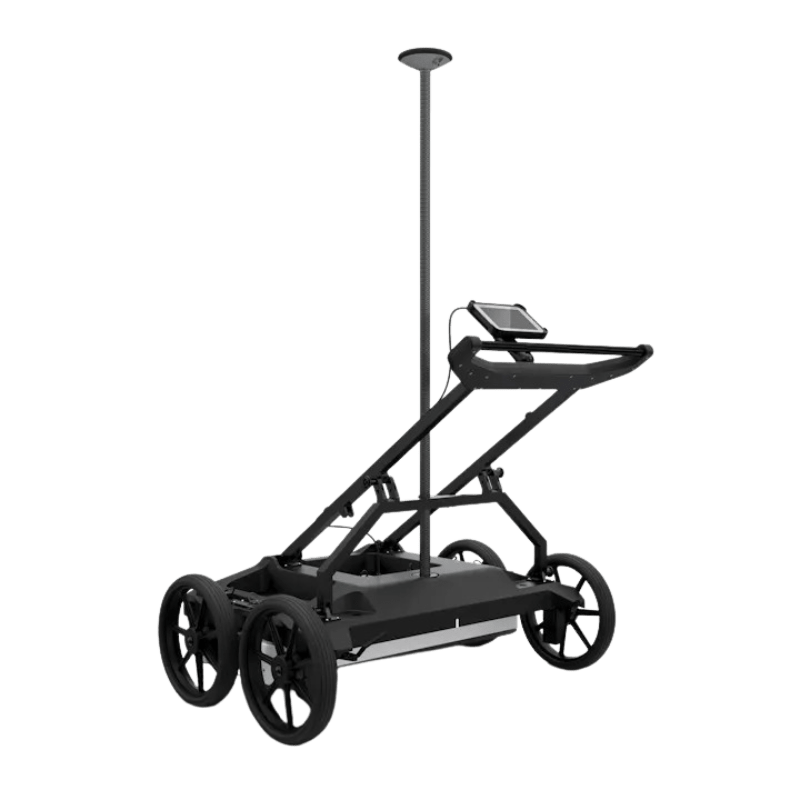
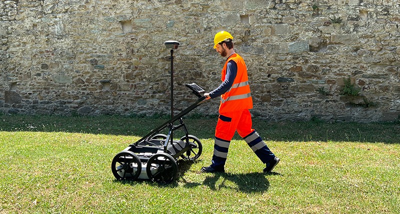
The Stream DP is a next-generation 3D Ground Penetrating Radar (GPR) designed for fast, accurate underground utility mapping and subsurface investigations. Built on advanced dual polarization technology, it delivers unmatched data quality, high acquisition speed, and deep penetration even in challenging ground conditions. Stream DP offers true 3D visualization of buried structures with real-time results, making it ideal for infrastructure assessment, urban mapping, and utility detection.
Description
Maximum depth, high resolution and versatile design for superior productivity in underground surveys.

Stream DP – Advanced Multichannel GPR Array for Real-Time 3D Underground Mapping
The Stream DP represents a breakthrough in multichannel Ground Penetrating Radar (GPR) technology, engineered for real-time 3D mapping of underground utilities and buried structures. Redefining the standards of subsurface surveys, Stream DP introduces Equalized scrambled Technology (EsT) by IDS GeoRadar, setting a new benchmark for detection depth and data clarity.
Designed for precision and performance, Stream DP delivers unmatched subsurface visibility, extending detection range beyond any comparable GPR solution available on the market.
Compact, Lightweight, and Ergonomic
With an ergonomic design optimized for ease of handling and mobility, the system can be deployed efficiently by a single operator. Each module weighs under 20 kg, and the compact 116 × 82 cm frame fits comfortably inside a standard vehicle, ensuring effortless transport between survey sites.
Engineered for Productivity and Reliability
Stream DP belongs to the Stream family of advanced GPR systems, which includes Stream T, Stream UP, and Stream X, designed for cutting-edge underground utility investigation.
Key Advantages of Stream DP
- AiMaps 2.0 – Enhanced with Artificial Intelligence for next-generation performance. A cloud-based platform streamlines data processing and interpretation, delivering clear, actionable results.
- Revolutionary EsT Technology – Provides precise signal control, extended depth penetration, and ultra-high resolution imaging for the most detailed subsurface insights.
- Exceptional Productivity – A massive array of 30 channels (19VV + 11HH) enables accurate 3D reconstruction of underground networks in a single pass.
- Operational Efficiency – Assembled in under five minutes by one operator, the system is compatible with standard transportation vehicles.
- Continuous Operation – Optimized for long-duration surveys with low power consumption (15W–19W) and hot-swap battery support for uninterrupted performance.
- Configurable Design – Adaptable to diverse applications with both rugged and asphalt configurations.
- Remote Diagnostics – Integrated Cloud-based diagnostics allow real-time system monitoring and troubleshooting from field device to customer support.
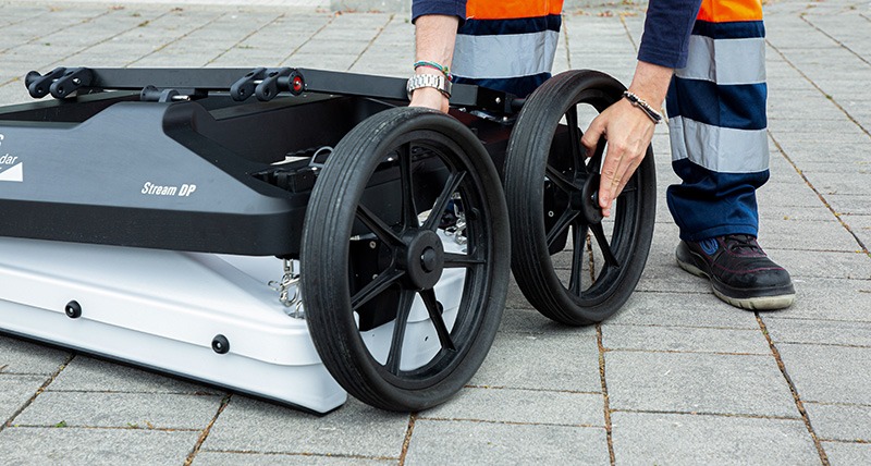
Asphalt and Rugged Configurations
The Stream DP Ground Penetrating Radar is built as a modular system engineered to perform efficiently across diverse environments. Its adaptable design supports both asphalt configurations—featuring pivoting wheels for smooth movement on paved surfaces—and rugged configurations equipped with terrain wheels for reliable operation on uneven ground. This versatility ensures optimal data collection performance in every field condition.
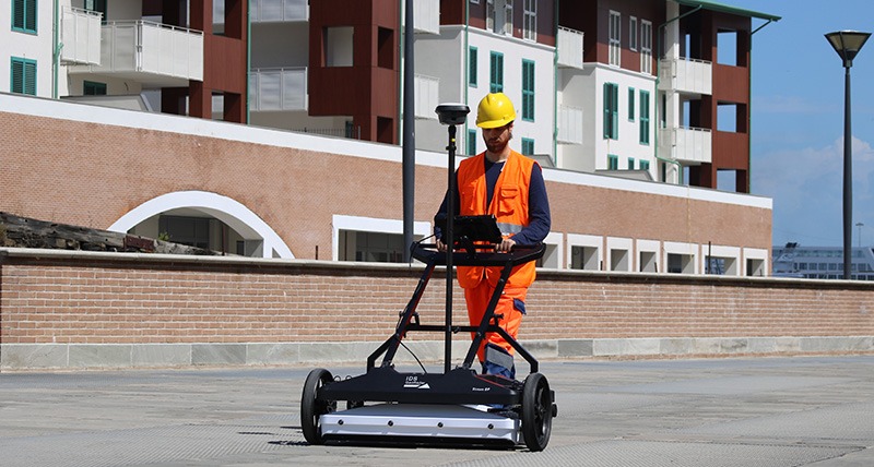
Fast Assembly and Easy Deployment
Engineered for convenience, Stream DP enables quick setup and deployment by a single operator. The system can be fully assembled and ready for surveying in under five minutes, allowing professionals to begin scanning directly in the field with minimal preparation time.
Exceptional Positioning Accuracy
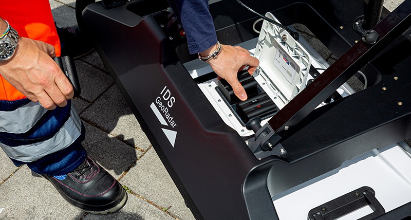
The integration of Pulse-Per-Second (PPS) technology within Stream DP’s antenna ensures precise synchronization with GPS systems. This feature provides highly accurate georeferenced positioning data, essential for achieving precise data alignment and reliable subsurface mapping.
Advanced Data Management and Software Integration
Stream DP utilizes state-of-the-art software solutions for efficient data handling, from acquisition to post-processing and interpretation:
- uMap – Field-ready software designed for seamless and intuitive radar data collection.
- IQMaps – A powerful post-processing tool with cloud integration, enabling faster, smarter analysis of subsurface information.
- AiMaps 2.0 – An intelligent visualization platform powered by Artificial Intelligence, offering an advanced view of underground utilities for enhanced safety and decision-making.
EsT – Equalized Scrambled Technology
The Equalized Scrambled Technology (EsT) represents a major advancement in ground penetrating radar (GPR) performance, setting a new benchmark for deep utility detection. This patented innovation from IDS GeoRadar allows the Stream DP to utilize the full radiating capability of its antenna, providing complete control of the GPR signal.
By capturing both low and high frequencies simultaneously, EsT technology ensures an extended depth range while maintaining ultra-high resolution. Its superior noise rejection and signal balancing result in cleaner, more reliable subsurface data.
Thanks to this cutting-edge design, Stream DP achieves levels of detection previously unattainable, eliminating the traditional trade-off between depth and resolution. The result is a radar system capable of locating buried utilities and structures with maximum precision across a wide range of ground conditions.
AiMaps 2.0 – Intelligent Data Visualization
AiMaps 2.0 is an advanced Artificial Intelligence-powered platform that enhances the efficiency and accuracy of utility detection and mapping. Integrated into the Stream DP workflow, AiMaps 2.0 provides intuitive visualization tools that deliver clearer and more meaningful representations of underground data.
This next-generation solution streamlines survey interpretation by automatically identifying and classifying buried features, significantly improving data accuracy and productivity. By enabling faster, smarter, and safer decision-making, AiMaps 2.0 empowers operators to gain deeper insights into the underground environment with confidence.
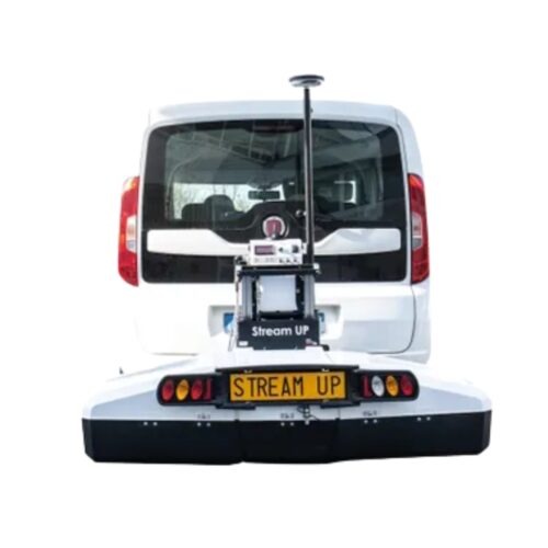
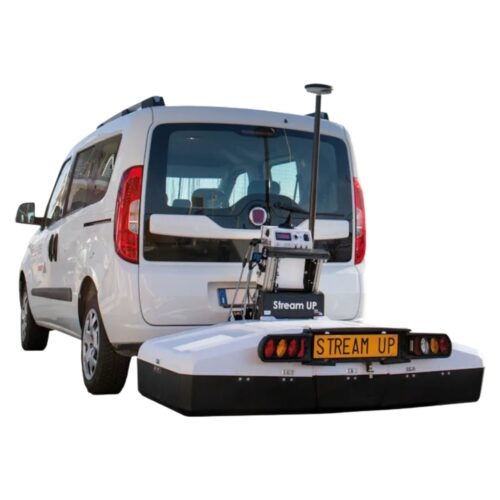
Stream UP Video
For privacy reasons YouTube needs your permission to be loaded. For more details, please see our Privacy Policy.
Brand
Leica Geosystems
Leica Geosystems Saudi Arabia – Precision Meets Innovation
Introduction
Leica Geosystems Saudi Arabia delivers unmatched precision, durability, and advanced geospatial performance for professionals across construction, infrastructure, mining, and agriculture. For over 200 years, Leica has pioneered surveying instruments, GNSS/GPS systems, laser scanners, and software platforms that empower projects worldwide.
Trusted Worldwide, Available Locally in Saudi Arabia
Founded in Switzerland, Leica Geosystems has built a legacy of engineering excellence. Now available in Saudi Arabia through authorized dealers, Leica Geosystems Saudi Arabia products are adapted for the region’s challenging environments—providing local support, training, and calibrated precision.
Innovation in Every Leica Geosystems Product
Ranging from sophisticated total stations and GNSS receivers to mobile mapping and high-definition laser scanners, Leica Geosystems Saudi Arabia offers real-time accuracy and seamless digital workflows that boost project efficiency and reduce field downtime.
Key Achievements & Milestones
-
Over 200 years of geomatics innovation
-
Inventor of the world’s first digital level and early laser distance meters
-
Reality capture systems deployed in 100+ countries
-
Trusted in major infrastructure, metro, and oil & gas surveying
-
Adopted by engineers, surveyors, and government agencies worldwide
Why Choose Leica Geosystems in Saudi Arabia?
-
Localized support: Technical assistance, training, and product availability through authorized dealers
-
Unmatched accuracy: Instruments deliver centimeter-level precision and durability
-
Comprehensive portfolio: Full range from DISTO distance meters to robotic total stations and reality capture systems
-
Smart integration: Compatible with Hexagon, Autodesk, and other industry-leading software platforms
Leica Product Range in KSA
-
Total Stations – Manual and robotic total stations for construction and high-precision surveying.
-
Mobile Mapping Systems – Pegasus TRK Neo, Pegasus:Backpack, BLK2GO for vehicle, wearable, and handheld 3D capture
-
GPS & GNSS Equipment – GS18 I GNSS RTK rover, iCON GPS smart antennas offering tilt-compensated precision positioning
-
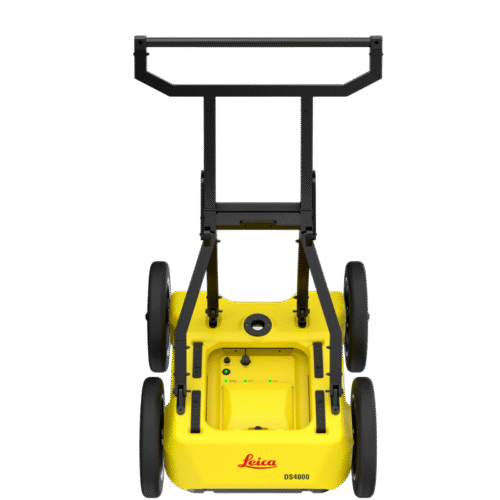
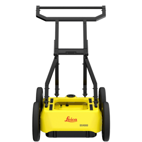
Ground Penetrating Radar (GPR) – Leica GPR solutions for accurate subsurface mapping
-
Laser Scanners – ScanStation P‑Series, RTC360, BLK360, and BLK2FLY for HD 3D scanning and digital twin workflows
-
DISTO Laser Distance Meters & Levels – Leica DISTO™ meter series and LINO/Rugby laser levels for point‑to‑point measurements and leveling
Leica Cyclone Software Portfolio
-
Cyclone REGISTER 360 PLUS – Guided workflows to register and visualize point cloud datasets with automation for efficient office workflows
-
Cyclone 3DR – End-to-end solution to analyze and model point clouds into actionable 3D deliverables
-
Cyclone Enterprise – On‑premise project and data management platform for centralized reality capture workflows
-
Cyclone Cloud – Subscription-based SaaS portal offering centralized license management and secure cloud-hosted service access
Get in Touch - Contact Us
Discover how Leica Geosystems Saudi Arabia solutions can elevate your next project. Reach out to your authorized local distributor to request demos, pricing, and expert consultation tailored to your requirements.
Official Website: www.leica-geosystems.com
Leica Geosystems is a world leader in precision surveying and geospatial solutions with over 200 years of expertise. From total stations and GNSS/GPS receivers to 3D laser scanning systems, Leica products deliver exceptional accuracy and reliability for construction, infrastructure, and mapping projects in Saudi Arabia and worldwide.