-
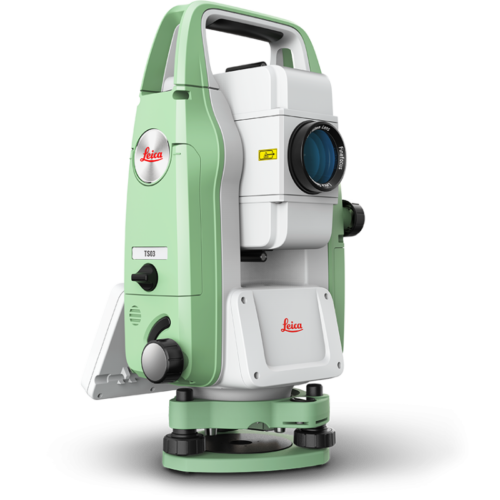
 The Leica FlexLine TS03 high-quality, manual total station is based on a proven product concept that has been revolutionising the world of measurement and survey for nearly 200 years. The Leica TS03 is equipped with a comprehensive application-based software package - Leica FlexField software - that enables most survey and stakeout tasks to be carried out easily and efficiently. The new FlexLine TS03 works reliably and delivers accurate results even in the harshest environments. • Work faster: measure more points per day due to faster measurement and stakeout procedures (endless drives, trigger key, drives on both sides, pinpoint EDM and more), supported by our comprehensive and user-friendly Leica FlexField software. • Use it trouble-free: increase productivity and minimise downtime by relying on instruments that simply work and come with a global service and support network. • Choose products that are built to last: FlexLine operates with the same high level of quality even after years of use under harsh conditions (like mud, dust, blowing rain, extreme heat and cold). • Control your investment: reliability, speed and accuracy ensure a lower investment over the product lifetime and a higher resell value.
 -
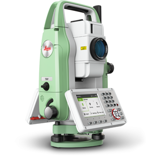
 The Leica FlexLine TS07 high-quality, manual total station is based on a proven product concept that has been revolutionising the world of measurement and survey for nearly 200 years. The Leica TS07 is equipped with a comprehensive application-based software package - Leica FlexField software - that enables most survey and stakeout tasks to be carried out easily and efficiently. The new FlexLine TS07 works reliably and delivers accurate results even in the harshest environments. • Work faster: measure more points per day due to faster measurement and stakeout procedures (endless drives, trigger key, drives on both sides, pinpoint EDM and more), supported by our comprehensive and user-friendly Leica FlexField software. • Use it trouble-free: increase productivity and minimise downtime by relying on instruments that simply work and come with a global service and support network. • Choose products that are built to last: FlexLine operates with the same high level of quality even after years of use under harsh conditions (like mud, dust, blowing rain, extreme heat and cold). • Control your investment: reliability, speed and accuracy ensure a lower investment over the product lifetime and a higher resell value. • Save time with AutoHeight: measure, read and set the instrument height automatically with this revolutionary feature in the FlexLine TS07 (optional). Errors are minimised and the setup process onsite is faster.
 -
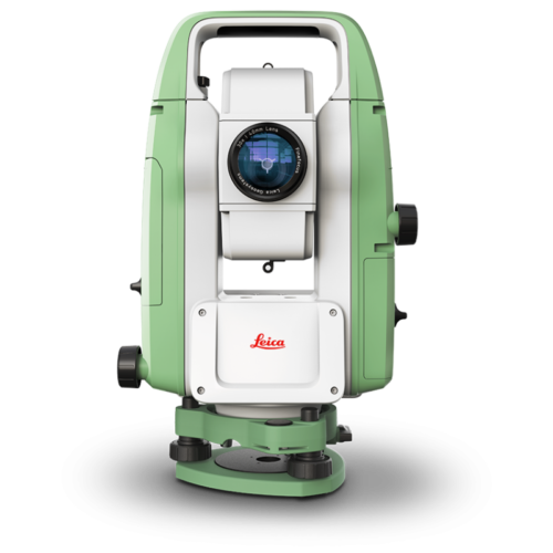
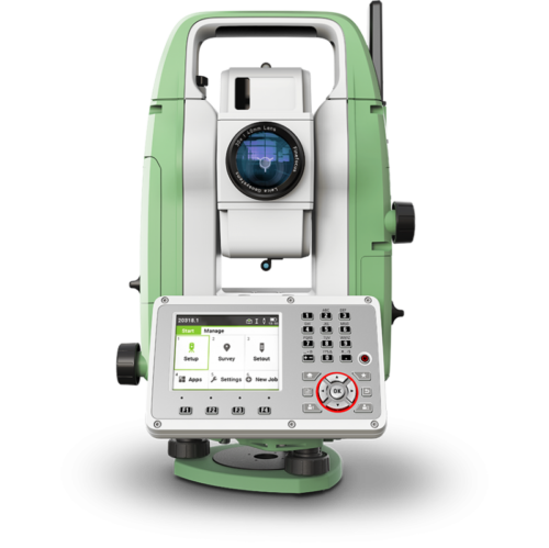
 The Leica FlexLine TS10 manual total station combines user-friendly, ergonomic design with high-end reliability under harsh conditions. It enables you to tie into the modern 3D dataflow, including enhanced linework and coding. The TS10 offers mobile data device integration as an option. The larger, highly visible colour- and touchscreen helps you to complete your surveying tasks with the highest speed and accuracy. The new FlexLine generation of manual total stations relies on a proven product concept that has been revolutionising the world of measurement and survey for nearly 200 years. • Work faster: measure more points per day due to faster measurements and stakeout procedures, supported by the revolutionary Leica Captivate field software. The software is made to make your work easier and more enjoyable. • Use it trouble-free: increase productivity and minimise downtime by relying on instruments that simply work and come with a global service and support network. • Choose products that are built to last: even after years of use under harsh conditions (like mud, dust, blowing rain, extreme heat and cold), FlexLine still operates with the same high level of quality. • Control your investment: reliability, speed and accuracy ensure a lower investment over the product lifetime and a higher resell value. • Save time with AutoHeight: this revolutionary feature enables the FlexLine TS10 manual total station to automatically measure, read and set the instrument height. Errors are minimised and the setup process onsite is faster.
 -
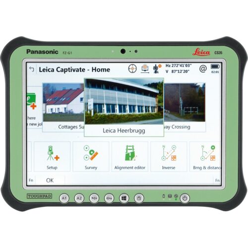
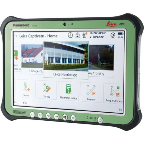
 The Leica TS13 total station provides a fast, reliable and efficient solution tailored to the users needs to measure and layout more points. Equipped with Automatic Target Recognition (ATR) technology and optionally with target lock and SpeedSearch to find and lock on to prisms quickly, it provides accurate measuring to targets. Combined with Leica Captivate field software, the TS13 offers a simple and productive way of coding and line work. The TS13 works with the revolutionary Leica Captivate field software, turning complex data into the most realistic and workable 3D models. It spans industries and applications with little more than a simple swipe, regardless of whether you work with GNSS, total stations or both. A smooth data transfer ensures the project stays on track. Captivate and Leica Infinity office software work in conjunction to join previous survey data and edit projects faster and more efficiently.
 -
 The Leica TS13 total station provides a fast, reliable and efficient solution tailored to the users needs to measure and layout more points. Equipped with Automatic Target Recognition (ATR) technology and optionally with target lock and SpeedSearch to find and lock on to prisms quickly, it provides accurate measuring to targets. Combined with Leica Captivate field software, the TS13 offers a simple and productive way of coding and line work. The TS13 works with the revolutionary Leica Captivate field software, turning complex data into the most realistic and workable 3D models. It spans industries and applications with little more than a simple swipe, regardless of whether you work with GNSS, total stations or both. A smooth data transfer ensures the project stays on track. Captivate and Leica Infinity office software work in conjunction to join previous survey data and edit projects faster and more efficiently. Kit includes:
- TS13 5" R500, total station with ATR
- TOP1, TS13 prism lock option
- TOP2, TS13 robotic option
- GDF311 Tribrach without optical plummet
- GST101 Wooden tripod w/ shoulder strap
- GLS11 reflector pole
- Height meter GHM007 with holder GHT196
- GEB221 Battery int. Li-Ion 7.4V/4400mAh
- GKL311 single Charger Prof 3000
- CS20 3.75G Field Controller
- Leica Captivate Measure & Stakeout CS20
- GEB331 Battery int Li-Ion 11.1V/2800mAh
- MSD1000, SD memory card 1GB
- GVP724 TS Robotic Container
- GRZ4 360° Reflector
- GHT63 Pole clamp for attaching GHT
- GHT66 Holder plate for CS20 controller
- RH17, Bluetooth RadioHandle
- 1 yr TS13+CS20 Basic CCP
-

Self-learning in any application
Meet the world’s first self-learning total station. Automatically adjusting to any environmental conditions, the Leica Viva TS16 locks onto your, and only your, target. Regardless of how challenging the task or the amount of distractions in the field, this total station exceeds your expectations. Cover a wide range of applications when this total station sees precisely what you see. Known for the most comprehensive imaging capability available, you can capture exact conditions for any worksite through the self-learning capability of the Leica Viva TS16.Engaging software
The Leica Viva TS16 total station comes with the revolutionary Captivate software, turning complex data into the most realistic and workable 3D models. With easy-to-use apps and familiar touch technology, all forms of measured and design data can be viewed in all dimensions. Leica Captivate spans industries and applications with little more than a simple swipe, regardless of whether you work with GNSS, total stations or both.Infinitely bridging the field to the office
While Leica Captivate captures and models data in the field, Leica Infinity processes the information back in the office. A smooth data transfer ensures the project stays on track. Leica Captivate and Leica Infinity work in conjunction to join previous survey data and edit projects faster and more efficiently.With ATRplus there is only one prism – yours
ATRplus, born from five generations of optimisation, takes known and trusted automation performance to the next level. This superior technology maximises the total station’s ability to remain locked on your target, ignoring other distractions in the field. The Leica Viva TS16 learns the environment, delivers accurate positions even in difficult dynamic applications, and offers the fastest re-lock in case of interrupted line of sight. -

 Known for its speed and precision, the Leica Nova TS60 is now a self-learning total station capable of adapting to any site condition. Let this new intuitive technology do the work for you. The only total station in the world that offers dedicated precision in the harshest conditions, the Leica Nova TS60 is designed for the highest accuracy down to the sub-millimetre and sub-second. Experience the meaning of perfected precision, maximum accuracy with the Leica Nova TS60.
Engaging software
The Leica Nova TS60 total station comes with the revolutionary Captivate software, turning complex data into the most realistic and workable 3D models. With easy-to-use apps and familiar touch technology, all forms of measured and design data can be viewed in all dimensions. Leica Captivate spans industries and applications with little more than a simple swipe, regardless of whether you work with GNSS, total stations or both.Infinitely bridging the field to the office
While Leica Captivate captures and models data in the field, Leica Infinity processes the information back in the office. A smooth data transfer ensures the project stays on track. Leica Captivate and Leica Infinity work in conjunction to join previous survey data and edit projects faster and more efficiently.With ATRplus there is only one prism – yours
ATRplus, born from five generations of optimisation, takes known and trusted automation performance to the next level. This superior technology maximises the total station’s ability to remain locked on your target, ignoring other distractions in the field. The Leica Nova TS60 learns the environment, delivers the most accurate positions even in difficult dynamic applications, and offers the fastest re-lock in case of interrupted line of sight. -
Don’t just see data, experience data
Never before has measurement technology provided such an intuitive experience or simple navigation. Incredibly easy software, instruments you trust, help that is only a click away – these combine to form an all-encompassing solution for your most challenging demands. Leica Captivate is the new software for the renowned Leica Nova and Viva measurement instruments. With familiar apps and touch technology, you can now capture and manage complex data with little more than a simple swipe.Dominant performance through seamless integration
The next generation of Leica Viva and Nova measuring instruments become the world’s first self-learning total stations and MultiStation with Leica Captivate. Transforming the Leica Viva GNSS experience, this engaging software joins ultimate GNSS receiver innovation with an industry-first 3D user immersion. Leica Captivate modernises the Leica Nova scanning experience, for the first time merging the overlay of measured points, 3D models and point clouds into a single view.Infinitely bridging the field to the office
While Leica Captivate captures and models data in the field, Leica Infinity processes the information back in the office. A smooth data transfer ensures the project stays on track. Leica Captivate and Leica Infinity work in conjunction to join previous survey data and edit projects faster and more efficiently. -
Self-learning in any application
Meet the world’s first self-learning total station. Automatically adjusting to any environmental conditions, the Leica Viva TS16 locks onto your, and only your, target. Regardless of how challenging the task or the amount of distractions in the field, this total station exceeds your expectations. Cover a wide range of applications when this total station sees precisely what you see. Known for the most comprehensive imaging capability available, you can capture exact conditions for any worksite through the self-learning capability of the Leica Viva TS16.Engaging software
The Leica Viva TS16 total station comes with the revolutionary Captivate software, turning complex data into the most realistic and workable 3D models. With easy-to-use apps and familiar touch technology, all forms of measured and design data can be viewed in all dimensions. Leica Captivate spans industries and applications with little more than a simple swipe, regardless of whether you work with GNSS, total stations or both.Infinitely bridging the field to the office
While Leica Captivate captures and models data in the field, Leica Infinity processes the information back in the office. A smooth data transfer ensures the project stays on track. Leica Captivate and Leica Infinity work in conjunction to join previous survey data and edit projects faster and more efficiently.With ATRplus there is only one prism – yours
ATRplus, born from five generations of optimisation, takes known and trusted automation performance to the next level. This superior technology maximises the total station’s ability to remain locked on your target, ignoring other distractions in the field. The Leica Viva TS16 learns the environment, delivers accurate positions even in difficult dynamic applications, and offers the fastest re-lock in case of interrupted line of sight. -
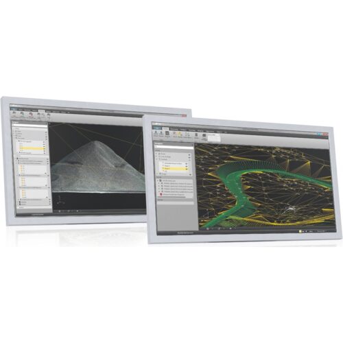
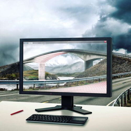
The bridge between field and office
Leica Infinity – the intuitive office software solution from Leica Geosystems Surveying also means the ability to handle information and data from the field and office in a flexible way and – as far as possible – from anywhere with fast accessibility and seamless data transfer. Today and more than ever before, you also need to rely on a seamless workflow in all your projects. To fulfil this need, we have developed Leica Infinity: a user-friendly, intelligent software platform with intelligent information architecture that opens up previously unimagined possibilities within many aspects of your workflow. More efficiency, greater transparency and simply better. -

Centralised point cloud project storage and access with ultra-high-speed rendering.
Leica JetStream provides state-of-the-art point cloud project performance and big data management for Leica CloudWorx users. JetStream overcomes the biggest challenges in productivity, ease-of use and scalability of ever increasingly large laser scan point cloud data inside of CAD systems. JetStream’s technology innovations deliver a completely new experience for point clouds in CAD. The instant open, all-the-points, all-the-time, paradigm is a revolutionary leap forward in performance. It drives better comprehension, increased productivity and removes the frustration and confusion of previously available solutions. JetStream’s streamlined project management completely insulates the CAD user from needing laser scanning expert knowledge. JetStream‘s centralised project storage simplifies and streamlines a team-work approach for unlimited sized workgroups. Features and Benefits- File sizes 5x to 10x smaller than traditional storage
- Instant loading and rendering of any sized project
- Pan and Zoom show, all-the-points, all-the-time
- Optimised bandwidth ensure fast network access
- “Ease-of-use” design simplifies using point clouds
- Centralised data storage and access removes duplication of data, simplifies back-ups and management, saves time and money
-
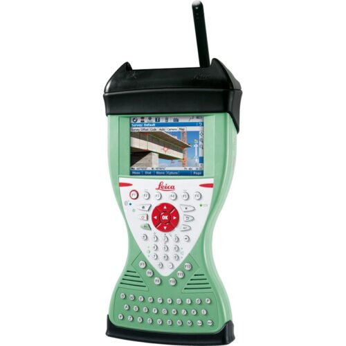
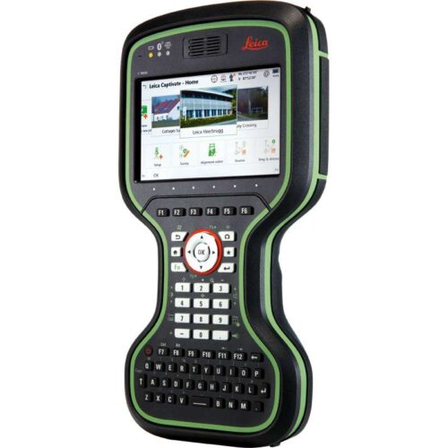
 The Leica Viva CS15 controller is an effective wireless field controller which comes with capable and easy to understand software to increase both work production and quality with your robotic Total Station. Suited for extreme environments, the Leica CS15 controller has an IP67 rating and is protected against dust, water and drops of just over a metre. Its operating temperature ranges between -30 to 60° C and is ergonomically designed to be comfortable in the hand. It is equipped with a fully illuminated QWERTY 65 key keypad and includes a 2 megapixel camera which can take pictures in the hand or when mounted on a pole. The CS15 also has the added benefit of displaying information using its fully illuminated VGA landscape colour touch screen. The Leica CS15 comes with Bluetooth® wireless connectivity, WLAN, 1 GB non-volatile flash storage and USB connector, 2.4GHz radio with internal antenna and 3.5G modem. Perfect suited for use with all Leica Viva series Total Stations with a fitted radio handle.
 -

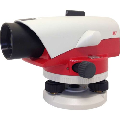
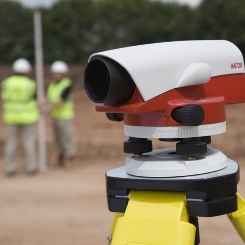
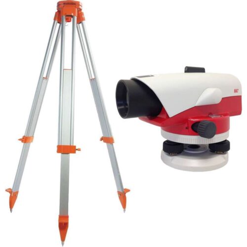 The Leica NA720 automatic level is extremely popular within the construction industry being known for its increased robustness and precision when working in tough environments. Onsite hazards such as falling to ground from a low height, exposure to water and vibrations caused by heavy machinery are no problem for the robust Leica NA720. With no need to re-adjust this level carries on working and measuring precisely, day in and day out. The horizontal circle and circular bubble are easily read, both being positioned next to the telescope and the external sight allowing for easy targeting. The upright image is clearly shown and the double sided endless drives provide fast targeting. The NA720 comes with one of the finest optics allowing for short measuring distances, measuring in adverse light conditions and accurate aiming. The increased tough and robust features of the NA720 include waterproof and protection against dust. The tight seals and gas filled telescope give protection against hazards should the instrument be dropped in to water.
Leica NA720 features include:
- 20x magnification
- Upright telescope image
- Gas filled telescope
- 30mm objective diameter
- 50cm short focus distance
- 360 degree / 400 gon selectable angle measurement
- 10’ / 2 mm circular bubble
- Endless Horizontal Drive
- 2.5mm double run accuracy
- ± 15’ working range
- Water resistant
- –20 to +50 °C operating temperature
- 1.6kg total weight
- 19cm x 12cm x 12cm
FS23 Aluminium Tripod
Robust construction. With shoulder carrying strap. Diameter of head: 158mm. Length: 1.05m. Extended length 1.7m. Weight: 5.1kg.Includes:
- Leica NA720 Automatic Level
- FS23 Aluminium Tripod
- Carry Case
- User Manual
-
 The Leica NA720 automatic level is extremely popular within the construction industry being known for its increased robustness and precision when working in tough environments. Onsite hazards such as falling to ground from a low height, exposure to water and vibrations caused by heavy machinery are no problem for the robust Leica NA720. With no need to re-adjust this level carries on working and measuring precisely, day in and day out. The horizontal circle and circular bubble are easily read, both being positioned next to the telescope and the external sight allowing for easy targeting. The upright image is clearly shown and the double sided endless drives provide fast targeting. The NA720 comes with one of the finest optics allowing for short measuring distances, measuring in adverse light conditions and accurate aiming. The increased tough and robust features of the NA720 include waterproof and protection against dust. The tight seals and gas filled telescope give protection against hazards should the instrument be dropped in to water.
Leica NA720 features include:
- 20x magnification
- Upright telescope image
- Gas filled telescope
- 30mm objective diameter
- 50cm short focus distance
- 360 degree / 400 gon selectable angle measurement
- 10’ / 2 mm circular bubble
- Endless Horizontal Drive
- 2.5mm double run accuracy
- ± 15’ working range
- Water resistant
- –20 to +50 °C operating temperature
- 1.6kg total weight
- 19cm x 12cm x 12cm
Includes:
- Leica NA720 Automatic Level
- Carry Case
- User Manual
-
The Leica FlexLine TS03 high-quality, manual total station is based on a proven product concept that has been revolutionising the world of measurement and survey for nearly 200 years. The Leica TS03 is equipped with a comprehensive application-based software package - Leica FlexField software - that enables most survey and stakeout tasks to be carried out easily and efficiently. The new FlexLine TS03 works reliably and delivers accurate results even in the harshest environments. • Work faster: measure more points per day due to faster measurement and stakeout procedures (endless drives, trigger key, drives on both sides, pinpoint EDM and more), supported by our comprehensive and user-friendly Leica FlexField software. • Use it trouble-free: increase productivity and minimise downtime by relying on instruments that simply work and come with a global service and support network. • Choose products that are built to last: FlexLine operates with the same high level of quality even after years of use under harsh conditions (like mud, dust, blowing rain, extreme heat and cold). • Control your investment: reliability, speed and accuracy ensure a lower investment over the product lifetime and a higher resell value.
-
The Leica FlexLine TS07 high-quality, manual total station is based on a proven product concept that has been revolutionising the world of measurement and survey for nearly 200 years. The Leica TS07 is equipped with a comprehensive application-based software package - Leica FlexField software - that enables most survey and stakeout tasks to be carried out easily and efficiently. The new FlexLine TS07 works reliably and delivers accurate results even in the harshest environments. • Work faster: measure more points per day due to faster measurement and stakeout procedures (endless drives, trigger key, drives on both sides, pinpoint EDM and more), supported by our comprehensive and user-friendly Leica FlexField software. • Use it trouble-free: increase productivity and minimise downtime by relying on instruments that simply work and come with a global service and support network. • Choose products that are built to last: FlexLine operates with the same high level of quality even after years of use under harsh conditions (like mud, dust, blowing rain, extreme heat and cold). • Control your investment: reliability, speed and accuracy ensure a lower investment over the product lifetime and a higher resell value. • Save time with AutoHeight: measure, read and set the instrument height automatically with this revolutionary feature in the FlexLine TS07 (optional). Errors are minimised and the setup process onsite is faster.
-
The Leica FlexLine TS10 manual total station combines user-friendly, ergonomic design with high-end reliability under harsh conditions. It enables you to tie into the modern 3D dataflow, including enhanced linework and coding. The TS10 offers mobile data device integration as an option. The larger, highly visible colour- and touchscreen helps you to complete your surveying tasks with the highest speed and accuracy. The new FlexLine generation of manual total stations relies on a proven product concept that has been revolutionising the world of measurement and survey for nearly 200 years. • Work faster: measure more points per day due to faster measurements and stakeout procedures, supported by the revolutionary Leica Captivate field software. The software is made to make your work easier and more enjoyable. • Use it trouble-free: increase productivity and minimise downtime by relying on instruments that simply work and come with a global service and support network. • Choose products that are built to last: even after years of use under harsh conditions (like mud, dust, blowing rain, extreme heat and cold), FlexLine still operates with the same high level of quality. • Control your investment: reliability, speed and accuracy ensure a lower investment over the product lifetime and a higher resell value. • Save time with AutoHeight: this revolutionary feature enables the FlexLine TS10 manual total station to automatically measure, read and set the instrument height. Errors are minimised and the setup process onsite is faster.
-
The Leica TS13 total station provides a fast, reliable and efficient solution tailored to the users needs to measure and layout more points. Equipped with Automatic Target Recognition (ATR) technology and optionally with target lock and SpeedSearch to find and lock on to prisms quickly, it provides accurate measuring to targets. Combined with Leica Captivate field software, the TS13 offers a simple and productive way of coding and line work. The TS13 works with the revolutionary Leica Captivate field software, turning complex data into the most realistic and workable 3D models. It spans industries and applications with little more than a simple swipe, regardless of whether you work with GNSS, total stations or both. A smooth data transfer ensures the project stays on track. Captivate and Leica Infinity office software work in conjunction to join previous survey data and edit projects faster and more efficiently.
-
The Leica TS13 total station provides a fast, reliable and efficient solution tailored to the users needs to measure and layout more points. Equipped with Automatic Target Recognition (ATR) technology and optionally with target lock and SpeedSearch to find and lock on to prisms quickly, it provides accurate measuring to targets. Combined with Leica Captivate field software, the TS13 offers a simple and productive way of coding and line work. The TS13 works with the revolutionary Leica Captivate field software, turning complex data into the most realistic and workable 3D models. It spans industries and applications with little more than a simple swipe, regardless of whether you work with GNSS, total stations or both. A smooth data transfer ensures the project stays on track. Captivate and Leica Infinity office software work in conjunction to join previous survey data and edit projects faster and more efficiently. Kit includes:
- TS13 5" R500, total station with ATR
- TOP1, TS13 prism lock option
- TOP2, TS13 robotic option
- GDF311 Tribrach without optical plummet
- GST101 Wooden tripod w/ shoulder strap
- GLS11 reflector pole
- Height meter GHM007 with holder GHT196
- GEB221 Battery int. Li-Ion 7.4V/4400mAh
- GKL311 single Charger Prof 3000
- CS20 3.75G Field Controller
- Leica Captivate Measure & Stakeout CS20
- GEB331 Battery int Li-Ion 11.1V/2800mAh
- MSD1000, SD memory card 1GB
- GVP724 TS Robotic Container
- GRZ4 360° Reflector
- GHT63 Pole clamp for attaching GHT
- GHT66 Holder plate for CS20 controller
- RH17, Bluetooth RadioHandle
- 1 yr TS13+CS20 Basic CCP
-
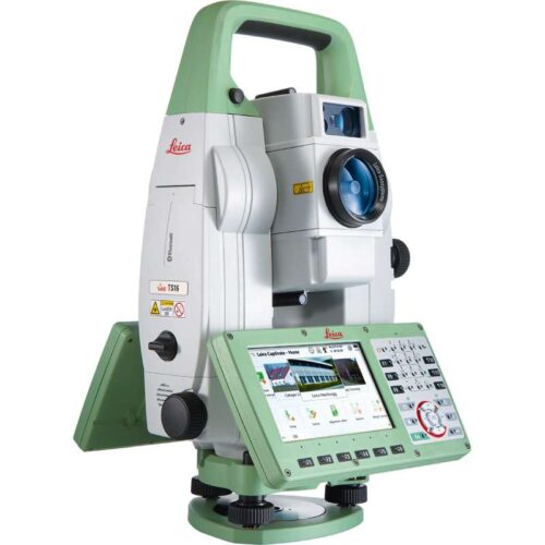
Self-learning in any application
Meet the world’s first self-learning total station. Automatically adjusting to any environmental conditions, the Leica Viva TS16 locks onto your, and only your, target. Regardless of how challenging the task or the amount of distractions in the field, this total station exceeds your expectations. Cover a wide range of applications when this total station sees precisely what you see. Known for the most comprehensive imaging capability available, you can capture exact conditions for any worksite through the self-learning capability of the Leica Viva TS16.Engaging software
The Leica Viva TS16 total station comes with the revolutionary Captivate software, turning complex data into the most realistic and workable 3D models. With easy-to-use apps and familiar touch technology, all forms of measured and design data can be viewed in all dimensions. Leica Captivate spans industries and applications with little more than a simple swipe, regardless of whether you work with GNSS, total stations or both.Infinitely bridging the field to the office
While Leica Captivate captures and models data in the field, Leica Infinity processes the information back in the office. A smooth data transfer ensures the project stays on track. Leica Captivate and Leica Infinity work in conjunction to join previous survey data and edit projects faster and more efficiently.With ATRplus there is only one prism – yours
ATRplus, born from five generations of optimisation, takes known and trusted automation performance to the next level. This superior technology maximises the total station’s ability to remain locked on your target, ignoring other distractions in the field. The Leica Viva TS16 learns the environment, delivers accurate positions even in difficult dynamic applications, and offers the fastest re-lock in case of interrupted line of sight. -
Known for its speed and precision, the Leica Nova TS60 is now a self-learning total station capable of adapting to any site condition. Let this new intuitive technology do the work for you. The only total station in the world that offers dedicated precision in the harshest conditions, the Leica Nova TS60 is designed for the highest accuracy down to the sub-millimetre and sub-second. Experience the meaning of perfected precision, maximum accuracy with the Leica Nova TS60.
Engaging software
The Leica Nova TS60 total station comes with the revolutionary Captivate software, turning complex data into the most realistic and workable 3D models. With easy-to-use apps and familiar touch technology, all forms of measured and design data can be viewed in all dimensions. Leica Captivate spans industries and applications with little more than a simple swipe, regardless of whether you work with GNSS, total stations or both.Infinitely bridging the field to the office
While Leica Captivate captures and models data in the field, Leica Infinity processes the information back in the office. A smooth data transfer ensures the project stays on track. Leica Captivate and Leica Infinity work in conjunction to join previous survey data and edit projects faster and more efficiently.With ATRplus there is only one prism – yours
ATRplus, born from five generations of optimisation, takes known and trusted automation performance to the next level. This superior technology maximises the total station’s ability to remain locked on your target, ignoring other distractions in the field. The Leica Nova TS60 learns the environment, delivers the most accurate positions even in difficult dynamic applications, and offers the fastest re-lock in case of interrupted line of sight. -
Don’t just see data, experience data
Never before has measurement technology provided such an intuitive experience or simple navigation. Incredibly easy software, instruments you trust, help that is only a click away – these combine to form an all-encompassing solution for your most challenging demands. Leica Captivate is the new software for the renowned Leica Nova and Viva measurement instruments. With familiar apps and touch technology, you can now capture and manage complex data with little more than a simple swipe.Dominant performance through seamless integration
The next generation of Leica Viva and Nova measuring instruments become the world’s first self-learning total stations and MultiStation with Leica Captivate. Transforming the Leica Viva GNSS experience, this engaging software joins ultimate GNSS receiver innovation with an industry-first 3D user immersion. Leica Captivate modernises the Leica Nova scanning experience, for the first time merging the overlay of measured points, 3D models and point clouds into a single view.Infinitely bridging the field to the office
While Leica Captivate captures and models data in the field, Leica Infinity processes the information back in the office. A smooth data transfer ensures the project stays on track. Leica Captivate and Leica Infinity work in conjunction to join previous survey data and edit projects faster and more efficiently. -
Don’t just see data, experience data
Never before has measurement technology provided such an intuitive experience or simple navigation. Incredibly easy software, instruments you trust, help that is only a click away – these combine to form an all-encompassing solution for your most challenging demands. Leica Captivate is the new software for the renowned Leica Nova and Viva measurement instruments. With familiar apps and touch technology, you can now capture and manage complex data with little more than a simple swipe.Dominant performance through seamless integration
The next generation of Leica Viva and Nova measuring instruments become the world’s first self-learning total stations and MultiStation with Leica Captivate. Transforming the Leica Viva GNSS experience, this engaging software joins ultimate GNSS receiver innovation with an industry-first 3D user immersion. Leica Captivate modernises the Leica Nova scanning experience, for the first time merging the overlay of measured points, 3D models and point clouds into a single view.Infinitely bridging the field to the office
While Leica Captivate captures and models data in the field, Leica Infinity processes the information back in the office. A smooth data transfer ensures the project stays on track. Leica Captivate and Leica Infinity work in conjunction to join previous survey data and edit projects faster and more efficiently. -
Self-learning in any application
Meet the world’s first self-learning total station. Automatically adjusting to any environmental conditions, the Leica Viva TS16 locks onto your, and only your, target. Regardless of how challenging the task or the amount of distractions in the field, this total station exceeds your expectations. Cover a wide range of applications when this total station sees precisely what you see. Known for the most comprehensive imaging capability available, you can capture exact conditions for any worksite through the self-learning capability of the Leica Viva TS16.Engaging software
The Leica Viva TS16 total station comes with the revolutionary Captivate software, turning complex data into the most realistic and workable 3D models. With easy-to-use apps and familiar touch technology, all forms of measured and design data can be viewed in all dimensions. Leica Captivate spans industries and applications with little more than a simple swipe, regardless of whether you work with GNSS, total stations or both.Infinitely bridging the field to the office
While Leica Captivate captures and models data in the field, Leica Infinity processes the information back in the office. A smooth data transfer ensures the project stays on track. Leica Captivate and Leica Infinity work in conjunction to join previous survey data and edit projects faster and more efficiently.With ATRplus there is only one prism – yours
ATRplus, born from five generations of optimisation, takes known and trusted automation performance to the next level. This superior technology maximises the total station’s ability to remain locked on your target, ignoring other distractions in the field. The Leica Viva TS16 learns the environment, delivers accurate positions even in difficult dynamic applications, and offers the fastest re-lock in case of interrupted line of sight. -
The bridge between field and office
Leica Infinity – the intuitive office software solution from Leica Geosystems Surveying also means the ability to handle information and data from the field and office in a flexible way and – as far as possible – from anywhere with fast accessibility and seamless data transfer. Today and more than ever before, you also need to rely on a seamless workflow in all your projects. To fulfil this need, we have developed Leica Infinity: a user-friendly, intelligent software platform with intelligent information architecture that opens up previously unimagined possibilities within many aspects of your workflow. More efficiency, greater transparency and simply better. -
Centralised point cloud project storage and access with ultra-high-speed rendering.
Leica JetStream provides state-of-the-art point cloud project performance and big data management for Leica CloudWorx users. JetStream overcomes the biggest challenges in productivity, ease-of use and scalability of ever increasingly large laser scan point cloud data inside of CAD systems. JetStream’s technology innovations deliver a completely new experience for point clouds in CAD. The instant open, all-the-points, all-the-time, paradigm is a revolutionary leap forward in performance. It drives better comprehension, increased productivity and removes the frustration and confusion of previously available solutions. JetStream’s streamlined project management completely insulates the CAD user from needing laser scanning expert knowledge. JetStream‘s centralised project storage simplifies and streamlines a team-work approach for unlimited sized workgroups. Features and Benefits- File sizes 5x to 10x smaller than traditional storage
- Instant loading and rendering of any sized project
- Pan and Zoom show, all-the-points, all-the-time
- Optimised bandwidth ensure fast network access
- “Ease-of-use” design simplifies using point clouds
- Centralised data storage and access removes duplication of data, simplifies back-ups and management, saves time and money
-
The Leica Viva CS15 controller is an effective wireless field controller which comes with capable and easy to understand software to increase both work production and quality with your robotic Total Station. Suited for extreme environments, the Leica CS15 controller has an IP67 rating and is protected against dust, water and drops of just over a metre. Its operating temperature ranges between -30 to 60° C and is ergonomically designed to be comfortable in the hand. It is equipped with a fully illuminated QWERTY 65 key keypad and includes a 2 megapixel camera which can take pictures in the hand or when mounted on a pole. The CS15 also has the added benefit of displaying information using its fully illuminated VGA landscape colour touch screen. The Leica CS15 comes with Bluetooth® wireless connectivity, WLAN, 1 GB non-volatile flash storage and USB connector, 2.4GHz radio with internal antenna and 3.5G modem. Perfect suited for use with all Leica Viva series Total Stations with a fitted radio handle.
-
The Leica NA720 automatic level is extremely popular within the construction industry being known for its increased robustness and precision when working in tough environments. Onsite hazards such as falling to ground from a low height, exposure to water and vibrations caused by heavy machinery are no problem for the robust Leica NA720. With no need to re-adjust this level carries on working and measuring precisely, day in and day out. The horizontal circle and circular bubble are easily read, both being positioned next to the telescope and the external sight allowing for easy targeting. The upright image is clearly shown and the double sided endless drives provide fast targeting. The NA720 comes with one of the finest optics allowing for short measuring distances, measuring in adverse light conditions and accurate aiming. The increased tough and robust features of the NA720 include waterproof and protection against dust. The tight seals and gas filled telescope give protection against hazards should the instrument be dropped in to water.
Leica NA720 features include:
- 20x magnification
- Upright telescope image
- Gas filled telescope
- 30mm objective diameter
- 50cm short focus distance
- 360 degree / 400 gon selectable angle measurement
- 10’ / 2 mm circular bubble
- Endless Horizontal Drive
- 2.5mm double run accuracy
- ± 15’ working range
- Water resistant
- –20 to +50 °C operating temperature
- 1.6kg total weight
- 19cm x 12cm x 12cm
FS23 Aluminium Tripod
Robust construction. With shoulder carrying strap. Diameter of head: 158mm. Length: 1.05m. Extended length 1.7m. Weight: 5.1kg.Includes:
- Leica NA720 Automatic Level
- FS23 Aluminium Tripod
- Carry Case
- User Manual
-
The Leica NA720 automatic level is extremely popular within the construction industry being known for its increased robustness and precision when working in tough environments. Onsite hazards such as falling to ground from a low height, exposure to water and vibrations caused by heavy machinery are no problem for the robust Leica NA720. With no need to re-adjust this level carries on working and measuring precisely, day in and day out. The horizontal circle and circular bubble are easily read, both being positioned next to the telescope and the external sight allowing for easy targeting. The upright image is clearly shown and the double sided endless drives provide fast targeting. The NA720 comes with one of the finest optics allowing for short measuring distances, measuring in adverse light conditions and accurate aiming. The increased tough and robust features of the NA720 include waterproof and protection against dust. The tight seals and gas filled telescope give protection against hazards should the instrument be dropped in to water.
Leica NA720 features include:
- 20x magnification
- Upright telescope image
- Gas filled telescope
- 30mm objective diameter
- 50cm short focus distance
- 360 degree / 400 gon selectable angle measurement
- 10’ / 2 mm circular bubble
- Endless Horizontal Drive
- 2.5mm double run accuracy
- ± 15’ working range
- Water resistant
- –20 to +50 °C operating temperature
- 1.6kg total weight
- 19cm x 12cm x 12cm
Includes:
- Leica NA720 Automatic Level
- Carry Case
- User Manual
-
 The Leica NA724 automatic level is one of the popular instruments in the building and construction industry and is renowned for its toughness and precision when used in harsh conditions. Hazards including falling from a low height and beingexposed to water as well as vibrations caused by large machinery are never a problem for the tough Leica NA724. Re-adjustments are not needed as this level carries on measuring and working accurately every day, all day. The circular bubble and horizontal circle are easily read as they sit next to the telescope and the external sight which allows for easy approximate targeting. The image is shown upright and the double sided endless drives provide fast targeting. The NA724 comes with one of the finest optics allowing for short measuring distances, accurate aiming and measuring in adverse light conditions. The increased robustness and tough features of the NA724 include protections against water and dust. Tight seals and a gas filled telescope give protection against hazards should the instrument be dropped in to water for example.
Leica NA724 features include:
- 24x magnification
- Upright telescope image
- Gas filled telescope
- 36mm objective diameter
- 50cm short focus distance
- 360 degree / 400 gon selectable angle measurement
- 10’ / 2 mm circular bubble
- Endless Horizontal Drive
- 2mm double run accuracy
- ± 15’ working range
- Water resistant
- –20 to +50 °C operating temperature
- 1.6kg total weight
- 19cm x 12cm x 12cm
Includes:
- Leica NA724 Automatic Level
- Carry Case
- User Manual
-
The Leica NA728 automatic level one of the most popular construction instruments we provide. It is known for its increased robustness and precision on tough working environments. Onsite hazards including small drops to ground, exposure to water and large vibrations from heavy machinery are no issue for the tough Leica NA728. With no need for re-adjustments this level can continue to work and measure precisely day in, day out. The horizontal circle and bubble are easily read as they are positioned next to the telescope and external sight which allows for simple targeting. Upright images are shown clearly and the double sided endless drives provide fast targeting. The NA728 comes with extremely high quality optics which allow for short measuring distances, measuring in poor light conditions and precise aiming. Increased tough build and robust qualities of the NA728 include water and dust protection. The gas filled telescope and tight seals provide protection against daily hazards should the instrument be dropped in to water for example.
Leica NA728 features include:
- 28x magnification
- Upright telescope image
- Gas filled telescope
- 40mm objective diameter
- 50cm short focus distance
- 360 degree / 400 gon selectable angle measurement
- 10’ / 2 mm circular bubble
- Endless Horizontal Drive
- 1.5mm double run accuracy
- ± 15’ working range
- Water resistant
- –20 to +50 °C operating temperature
- 1.6kg total weight
- 21cm x 12cm x 12cm
Includes:
- Leica NA728 Automatic Level
- Carry Case
- User Manual
-
The Leica NA730 automatic level is the top of the NA700 series range and is very popular within the construction and building industry. It is known for its increased durability and accurate measuring on harsh working environments. The NA730 is tough, it protected against impacts and can survive short drops, exposure to water and withstand vibrations caused by large machinery. With no need to constantly re-adjust this levelling instrument can continually work and measure precisely all day, every day. The horizontal circle and bubble are easily identified as they are positioned next to the external sight and telescope for easy targeting. The image is shown upright and the double sided endless drives provide accurate targeting. The NA730 also has exceptional optics which allow for short measuring in adverse light conditions, measuring distances and accurate aiming. The increased robustness and durable features of the NA730 include dust and water protection. The build quality is second to none with tight seals and a gas filled telescope which aid protection against hazards should the instrument be dropped in to water for example.
Leica NA730 features include:
- 30x magnification
- Upright telescope image
- Gas filled telescope
- 40mm objective diameter
- 70cm short focus distance
- 360 degree / 400 gon selectable angle measurement
- 10’ / 2mm circular bubble
- Endless Horizontal Drive
- 1.2mm double run accuracy
- ± 15’ working range
- Water resistant
- –20 to +50 °C operating temperature
- 1.6kg total weight
- 21cm x 12cm x 12cm
Includes:
- Leica NA730 Automatic Level
- Carry Case
- User Manual
-
The Leica NA730 plus automatic level is the top of the NA700 series range and is very popular within the construction and building industry. It is known for its increased durability and accurate measuring on harsh working environments. The NA730 plus is tough, it protected against impacts and can survive short drops, exposure to water and withstand vibrations caused by large machinery. With no need to constantly re-adjust this levelling instrument can continually work and measure precisely all day, every day. The horizontal circle and bubble are easily identified as they are positioned next to the external sight and telescope for easy targeting. The image is shown upright and the double sided endless drives provide accurate targeting. The NA730 plus also has exceptional optics which allow for short measuring in adverse light conditions, measuring distances and accurate aiming. The increased robustness and durable features of the NA730 plus include dust and water protection. The build quality is second to none with tight seals and a gas filled telescope which aid protection against hazards should the instrument be dropped in to water for example.
Leica NA730 plus features include:
- 30x magnification
- Upright telescope image
- Gas filled telescope
- 40mm objective diameter
- 70cm short focus distance
- 360 degree / 400 gon selectable angle measurement
- 10’ / 2mm circular bubble
- Endless Horizontal Drive
- 1.2mm double run accuracy
- ± 15’ working range
- Water resistant
- –20 to +50 °C operating temperature
- 1.6kg total weight
- 21cm x 12cm x 12cm
Includes:
- Leica NA730 plus Automatic Level
- Carry Case
- User Manual
-
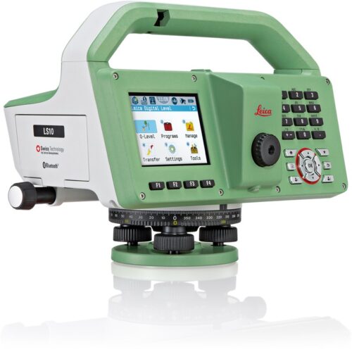
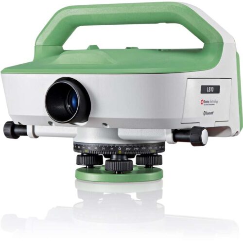
More comfort with exceptionally reliable results
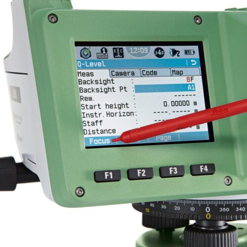
Complicated infrastructure demands the uppermost accuracy when defining and setting out reference heights. With dedication in striving forward, Leica Geosystems have produced the Leica LS10 & LS15 Digital Levels to provide an enjoyable field experience. From measuring roads, railways, bridges or other structures, the Leica LS Digital Levels provide reassurance and ease to an extensive range of complicated levelling applications. The Leica LS15 achieves all project steps, simplifying demanding tasks associated with the levelling process. 0.2 mm accuracy is accomplished by aiming at the target with the use of the colour touch display and pressing the measuring control. Features such as an electronic bubble, autofocus and tilt checks prior to each measurement help to reduce measuring professionals’ fatigue over a day’s work, reducing the risk of human-based errors.Faster staff sighting
The Leica LS15 Digital Level is the only one on the market which is equipped with a camera and enables target staffs to be sighted quicker. Operators need to simply locate the staff on the cameras touch screen display and press the measuring button which automatically records the staff reading and measurement data.Precise hardware
Automated functions and industry-leading 0.2 mm accuracy to standard Invar staffs deliver unmatched reliability. Precision begins by using the electronic level bubble to set up instruments. After one button press, automatic tilt checks are made prior to each measurement. Integrated autofocus not only finds your target faster, it increases measurement accuracy by maximising contrast of the staff.Infinitely bridging field to office
The field experience of Leica LS digital levels does not finish in the field. After easily transferring your data to the office via a USB or Bluetooth®, Leica Infinity processes your results hassle-free back in the office. This intuitive software enables easy-tounderstand displays of complex levelling data. Combine tables with graphics or even cross check project data in one window for one overall view of level lines, line calculations or adjustments.Highest Accuracy
- 0.2 mm accuracy even with standard Invar staffs
- Electronic level bubble for perfect instrument setup
- Tilt check prior to each measurement
- Autofocus for maximal contrast of staff
Efficiency of Work
- Digital camera enables fast and accurate staff sighting
- Streamline levelling processes with just one push of a button
- Fast and easy data transfer using USB and Bluetooth® connectivity
Field Experience
- Visualisation of level lines in the field and in the office
- Screenshots document site and field results
- Step-by-step display guidance for levelling line flows
-
More comfort with exceptionally reliable results
Complicated infrastructure demands the uppermost accuracy when defining and setting out reference heights. With dedication in striving forward, Leica Geosystems have produced the Leica LS10 & LS15 Digital Levels to provide an enjoyable field experience. From measuring roads, railways, bridges or other structures, the Leica LS Digital Levels provide reassurance and ease to an extensive range of complicated levelling applications. The Leica LS15 achieves all project steps, simplifying demanding tasks associated with the levelling process. 0.2 mm accuracy is accomplished by aiming at the target with the use of the colour touch display and pressing the measuring control. Features such as an electronic bubble, autofocus and tilt checks prior to each measurement help to reduce measuring professionals’ fatigue over a day’s work, reducing the risk of human-based errors.Faster staff sighting
The Leica LS15 Digital Level is the only one on the market which is equipped with a camera and enables target staffs to be sighted quicker. Operators need to simply locate the staff on the cameras touch screen display and press the measuring button which automatically records the staff reading and measurement data.Precise hardware
Automated functions and industry-leading 0.2 mm accuracy to standard Invar staffs deliver unmatched reliability. Precision begins by using the electronic level bubble to set up instruments. After one button press, automatic tilt checks are made prior to each measurement. Integrated autofocus not only finds your target faster, it increases measurement accuracy by maximising contrast of the staff.Infinitely bridging field to office
The field experience of Leica LS digital levels does not finish in the field. After easily transferring your data to the office via a USB or Bluetooth®, Leica Infinity processes your results hassle-free back in the office. This intuitive software enables easy-tounderstand displays of complex levelling data. Combine tables with graphics or even cross check project data in one window for one overall view of level lines, line calculations or adjustments.Highest Accuracy
- 0.2 mm accuracy even with standard Invar staffs
- Electronic level bubble for perfect instrument setup
- Tilt check prior to each measurement
- Autofocus for maximal contrast of staff
Efficiency of Work
- Digital camera enables fast and accurate staff sighting
- Streamline levelling processes with just one push of a button
- Fast and easy data transfer using USB and Bluetooth® connectivity
Field Experience
- Visualisation of level lines in the field and in the office
- Screenshots document site and field results
- Step-by-step display guidance for levelling line flows
-
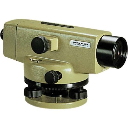 The NA2 automatic level is the flagship optical level product from Leica Geosystems. Designed by leading surveyors and developed by highly skilled engineers with a great deal of experience in knowing what an instrument must achieve in the field. Created for all types of surveying task, the NA2 is highly precise and efficient when doing routine levelling task on building sites, for geodetic control at all levels of accuracy, and in engineering projects. For additional precision it can be coupled with the optional GPM3 Parallel Plate Micrometer. Features of the NA2
- Suited for levelling of all orders and types of accuracy
- Accurate settlement and levelling determinations
- Routine heighting for road, railway, pipeline, and tunnel construction
- Control measurements and setting-out work on site
- High accuracy area levelling
- K-version on flat terrain provides Tacheometric levelling by bringing together stadia and angular measurements with height readings
- Bridge monitoring and deformation measurement
-
The NAK2 automatic level is the flagship optical level product from Leica Geosystems. Designed by leading surveyors and developed by highly skilled engineers with a great deal of experience in knowing what an instrument must achieve in the field. Created for all types of surveying task. the NAK2 is economical and productive for routine levelling task on building sites, for geodetic control at all levels of accuracy, and in engineering projects. Features of the NAK2
- Suited for levelling of all orders and types of accuracy
- Accurate settlement and levelling determinations
- Routine heighting for road, railway, pipeline, and tunnel construction
- Control measurements and setting-out work on site
- High accuracy area levelling
- K-version on flat terrain provides Tacheometric levelling by bringing together stadia and angular measurements with height readings
- Bridge monitoring and deformation measurement
-
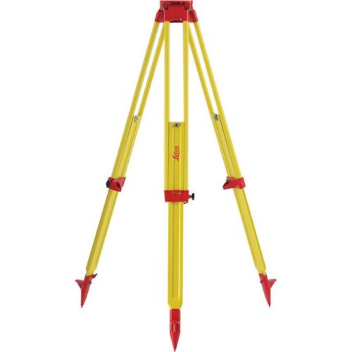 Heavy-duty surveying tripod. Self-closing, with carrying strap and side clamp screws. Twist-proof and good vibration characteristics. Robust tripod for general use. Suitable for levels, lasers, total stations and GPS. Length: 1.1m. Extended length: 1.80m. Weight: 6.4kg.
 -
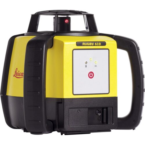
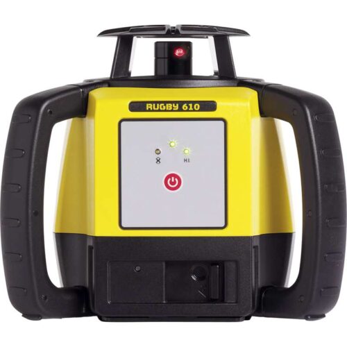
Leica Rugby 610 – Single Button Simplicity
The Leica Rugby 610 is an excellent general construction horizontal laser level. This new laser squares, aligns and levels faster and easier than ever before increasing work performance by eradicating errors and downtime easily and quickly at the touch of a button. The Leica Rugby 610 laser level is tough, fast and part of the Leica 600 series range which are known for their suitability on all types of construction work. The Rugby 610 laser is protected to IP67 dust and water protected and has a glass cage, tough housing and comes with rubber handles for grip to provide ultimate protection. Enhance the Leica Laser Rugby 610 with additional plug and play accessories. Charge and use at the same time with the environmentally friendly A170 Solar Panel, power from a vehicle with a car charger or any battery with the 12v battery cable. Increase performance when used with a Rod Eye receiver such as the 140 Classic or 160 Digital.
Includes:
- Rugby 610 and Carrying Case
- Rod Eye 120 Receiver
- Leica A600 Li-ion
- Leica A100 AC Charger
- Carry Case
-
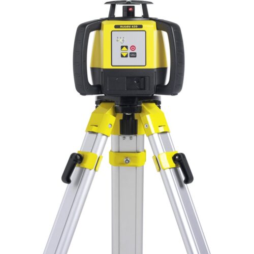
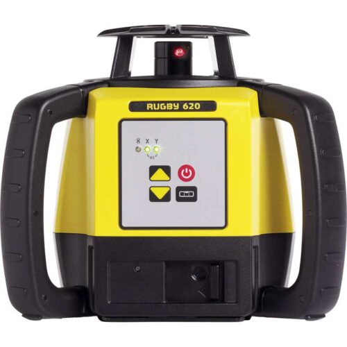
Leica Rugby 620 – Mistakes not possible
The Leica Rugby 620 Laser Level is an excellent self-levelling horizontal and manual slope in one axis general construction laser level. This new laser squares, aligns and levels faster and easier than ever before increasing work performance by eradicating errors and downtime. Foundations and footings work such as pad placement; framework levelling and concrete forming have never been more simple or efficient and all done quickly at the touch of a button. The NEW Leica Rugby 620 laser level is tough, fast and part of the Leica 600 series range which are known for their suitability on all types of construction work. The Rugby 620 laser is protected to IP67 dust and water protected and has a glass cage, tough housing and rubber handles for grip to provide ultimate protection. Enhance the Leica Laser Rugby 620 with additional plug and play accessories. Charge and use at the same time with the environmentally friendly A170 Solar Panel, power from a vehicle with a car charger or any battery with the 12v battery cable. Increase performance when used with a Rod Eye receiver such as the 140 Classic or 160 Digital.
Includes:
- Rugby 620 and Carrying Case
- Rod Eye 120 Receiver
- Leica A600 Li-ion
- Leica A100 AC Charger
- Carry Case
-
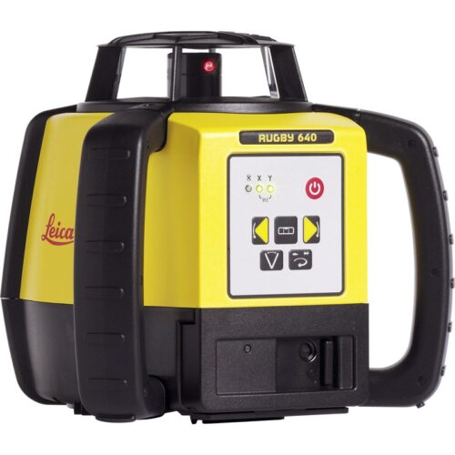
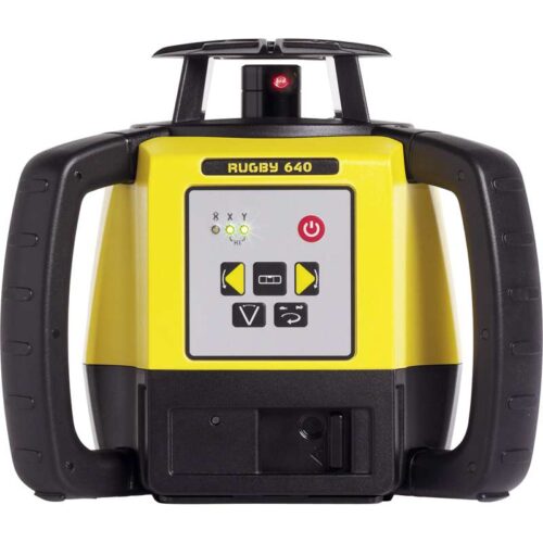
Leica Rugby 640 – Interior and Exterior Versatility
The Leica Rugby 640 Laser Level is a multipurpose self-levelling vertical, horizontal, manual and 90° slope in dual axis construction laser level. This new laser squares, aligns and levels faster and easier than ever before increasing work performance by eradicating errors and downtime. Foundations and footings work such as pad placement, framework levelling and concrete forming have never been more simple or efficient. The new Scan 90 feature makes layouts quicker allowing the beam to move to the left or right. It also has an automatic plumb down function and sleep mode which conserves power without losing any setup information. The NEW Leica Rugby 640 laser level is tough, fast and part of the Leica 600 series range which are known for their suitability on all types of construction work. The Rugby 610 laser is protected to IP67 dust and water protected and has a glass cage, tough housing and comes with rubber handles for grip to provide ultimate protection. Enhance the Leica Laser Rugby 640 with additional plug and play accessories. Charge and use at the same time with the environmentally friendly A170 Solar Panel, power from a vehicle with a car charger or any battery with the 12v battery cable. Increase performance when used with a Rod Eye receiver such as the 140 Classic or 160 Digital..
Includes:
- Rugby 640 and Carrying Case
- Rod Eye 120 Receiver
- Leica A600 Li-ion
- Leica A100 AC Charger
- Carry Case
-
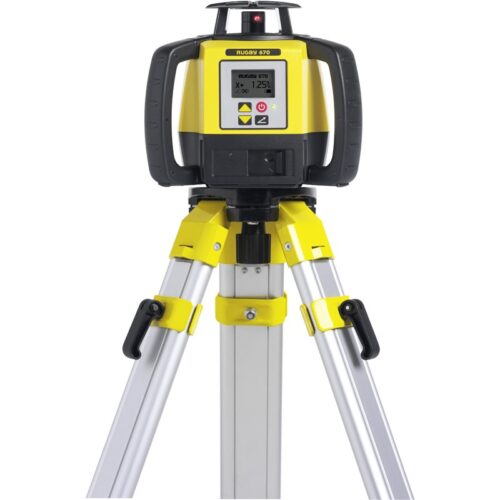
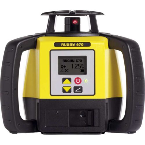
Leica Rugby 670 – High Performance Single Grade Laser Level
The Leica Rugby 670 Laser Level is an excellent semi-auto single grade construction laser level with digital efficiency. This new laser squares, aligns and levels faster and easier than ever before increasing work performance by eradicating errors and downtime. Foundations and footings work such as pad placement, framework levelling and concrete forming have never been more simple or efficient. The new Scan 90 feature makes layouts quicker allowing the beam to move to the left or right. It also has an automatic plumb down function and sleep mode which conserves power without losing any setup information. The Leica Rugby 670 includes a dial-in grade when used in dual or single axis mode and can be operated easily and quickly at the touch of a button. A unique Smart Slope feature will continue to monitor temperature and time to make sure performance and accuracy are maintained throughout its use. The NEW Leica Rugby 670 laser level is tough, fast and part of the Leica 600 series range which are known for their suitability on all types of construction work. The Rugby 670 laser is protected to IP67 dust and water protected and has a glass cage and tough housing which gives ultimate protection. It has rubber handles for grip, a large high contrast LCD display and a simple, easy to understand user interface. H-I and Bump alert feature alerts the operator of any disturbances and when the grade is used the smart slope function will continue to monitor in order to make sure accurate time and temperature results are provided all day long. Enhance the Leica Laser Rugby 670 with additional plug and play accessories. Charge and use at the same time with the environmentally friendly A170 Solar Panel, power from a vehicle with a car charger or any battery with the 12v battery cable. Increase performance when used with a Rod Eye receiver such as the 140 Classic or 160 Digital.
Includes:
- Rugby 670 and Carrying Case
- Rod Eye Receiver
- Leica A600 Li-ion
- Leica A100 AC Charger
- Carry Case
-
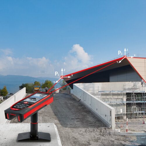
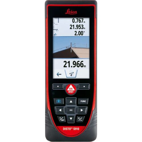
Measure anything, anytime, anywhere.
Measure quickly and accurate distances between two points from a single location with the Leica DISTO™ S910 laser distance meter. Generate effortlessly as-built documentation, determine rooftop dimensions and integrate information into CAD or BIM software for even 3D conceptions. This improved workflows saves valued time and money. All of this at distances of up to 300 meters.Features include:
- Smart Base for P2P Technology
- Pointfinder with 4x zoom for effortless targeting
- X-Range Power Technology for maximum measurement functioning
- 360° tilt sensor
- DXF data capture
- Data transfer in real-time with WLAN
- Bluetooth® Smart
- Free Leica DISTO™ sketch App
Includes:
- Leica DISTO™ S910 laser distance meter
- Smart Base Extension
- Holster
- Hand loop
- USB charger incl. 4 plugs

-
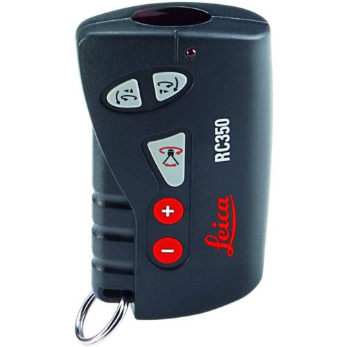 Can be used in conjunction with all of the Roteo lasers. Operates the laser from a distance up to 30m.