-
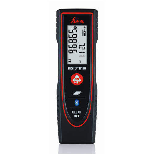 The New Leica Disto D110 is the smallest Disto with Bluetooth Smart on the market. Create floor plans and sketches very easily by connecting the new Leica D110 with the DISTO Sketch app on a Smartphone or tablet device.
 Leica Disto Sketch is the ideal interface between a DISTO and smart phone or tablet. They allow sketches or photographs to be created and dimensioned quickly, or the transfer of measurements into a chart. The data can be sent to the office by e-mail. This simplifies and speeds up your workflow.
Benefits of the Leica Disto D110:
- New ergonomic design for easy use
- Increased functionality with integrated Bluetooth Smart technology and Leica Disto Sketch app
- Perfect for fast indoor distance and area measurements
- Pocket clip to help with carrying
- Proven Leica quality and precision
- Measure precise distances with ±1.5mm accuracy
- Measure up to 60m distances without moving
- Ideal for the jobsite – Protected against splash water and dust
Technical Data
- Measuring Accuracy: ±1.5mm
- Range: 60m
- Measuring units: m, ft, in
- Includes: Power Range Technology, Illuminated Display, Free App
- Batteries: 2x AAA
- Protection Class: IP54 (splash water and dust)
- Dimensions: 120x37x23mm
- Weight: 92g
Includes:
- Leica DISTO D110 Laser Distance Meter
- Pocket Clip
- Holster
- 2x AAA Batteries.

-
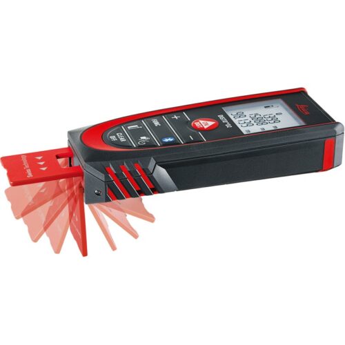
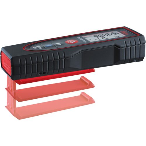
Compact laser distance meter with Bluetooth® Smart and multifunctional end-piece
The smallest laser distance measurer in the Disto range, the Leica DISTO D2 is versatile and ideal for use indoors. The Disto D2 has easy to use keys for subtraction, addition, volume and area calculations. The D2 is very compact, ergonomic and handy making it a capable tool, especially for its size.
Benefits & functions of the Leica DISTO D2
- Bluetooth Smart (4.0)
- Easy and fast - The Leica DISTO D2 gives measurements at the press of a single button.
- Measure areas and volumes
- Excellent Memory - The last 10 results are kept for fast access.
- Compact - Thanks to its ergonomic and small and includes a soft grip. Leica DISTO D2 fits nicely in your hand and into any pocket.
- Easy to read display - Measurements are shown on a 3-line illuminated display, readable in the dark.
- Min / max results, tracking and storage makes your work much easier.
- Shortcut keys - Easy-to-use for frequently used functions
- Flip-out end-piece – For measuring from edges or corners
- Protected to IP54 - Dust and splash proof
- Pythagorean functions - Indirect width and height measurements for inaccessible positions
- Delayed time - Measure without shake
- Painter Function
- Stake Out Function
- Intelligent Endpiece
Package includes:

- Leica Disto D2 laser distance meter
- Disto Holster
- Secure hand loop
- Batteries
-
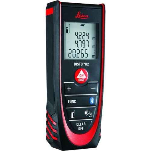
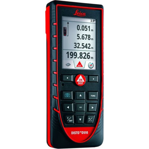 The Leica DISTO™ D510 is an easy to use laser distance meter with an intuitive interface and 200m range. The Pointfinder with 4x zoom allows for accurate measuring where there is no reflective target which can occur when working outside in bright conditions. The 360° tilt sensor can measure both angles and distances and can be used in conjunction with the Pointfinder to provide indirect measurements. The Disto D510 is also extremely durable and ideal for all working environments and weather conditions. It is protected to IP65 rating and is protected against water and also dust proof, making it very easy to clean. The Disto D510 is Bluetooth® Smart Ready so it easily transfers measuring information to other devices such as the iPad and iPhone simply and can be used with the FREE Leica Disto Sketch app (available from iTunes). Easily draw sketches and assign measuring results. Use the app to edit or overwrite photographs and draw ground plans or tables.
Leica Disto Sketch is the ideal interface between a DISTO and smart phone or tablet. They allow sketches or photographs to be created and dimensioned quickly, or the transfer of measurements into a chart. The data can be sent to the office by e-mail. This simplifies and speeds up your workflow.
The Leica DISTO™ D510 is an easy to use laser distance meter with an intuitive interface and 200m range. The Pointfinder with 4x zoom allows for accurate measuring where there is no reflective target which can occur when working outside in bright conditions. The 360° tilt sensor can measure both angles and distances and can be used in conjunction with the Pointfinder to provide indirect measurements. The Disto D510 is also extremely durable and ideal for all working environments and weather conditions. It is protected to IP65 rating and is protected against water and also dust proof, making it very easy to clean. The Disto D510 is Bluetooth® Smart Ready so it easily transfers measuring information to other devices such as the iPad and iPhone simply and can be used with the FREE Leica Disto Sketch app (available from iTunes). Easily draw sketches and assign measuring results. Use the app to edit or overwrite photographs and draw ground plans or tables.
Leica Disto Sketch is the ideal interface between a DISTO and smart phone or tablet. They allow sketches or photographs to be created and dimensioned quickly, or the transfer of measurements into a chart. The data can be sent to the office by e-mail. This simplifies and speeds up your workflow.
At a glance:
- Easy to use
- 200m Range
- Intuitive user interface
- Bluetooth® Smart Ready
- Communicates with Apple iPad, iPhone
- Free App – Leica DISTO™ sketch
- Pointfinder with 4x zoom
- Protected to IP65 – water jet protection and dust-tight extremely robust for all working environments
- 360° tilt sensor
- Smart Horizontal Mode™
- Height tracking
Includes:
- Leica DISTO™ D510 laser distance meter
- Holster
- Hand loop
- Batteries
-
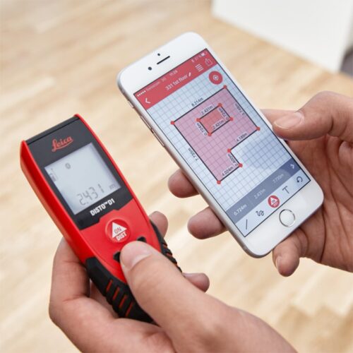
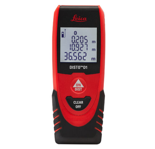
Old fashioned measuring tape versus laser precision? There’s no comparison.
The Leica Disto D1 measures distances and heights of up to 40m like a pro and there’s no need of a ladder, a slack steel tape or a tired companion. You’ll get 2 mm accuracy with just one press of a button. It’ll save you time and reduce errors. Difficult or unsafe measuring situations are now in the past. The Leica Disto D1 provides professionals as well as DIY users with a fast, reliable and easy-to-use laser measuring tool. One measurement is enough and the result can be effortlessly read off the clear display. Just turn on the Bluetooth™ Smart enabled Leica D1 and it can connect with the Disto Sketch app. Create photos or sketches and dimension them with the results, which are transmitted directly to your tablet or smart phone. Plans are automatically completed with circumferences and areas. Disto Sketch integrates measurements into job-site sketches or project images to speed up workflows and finished jobs faster. Error-free information of projects is sent instantly back to the site or office. Enjoy the convenience of modern simplicity with renowned Leica precision and quality. Compact and lightweight, the D1 is never out of reach.
Featured with
- Bluetooth® Smart for data transfer to smart phones and tablets
- Free App Leica DISTO™ sketch
- 40meter range
- XRange Power Technology
- Clear, illuminated display
- IP54 splash water and dust protected
-
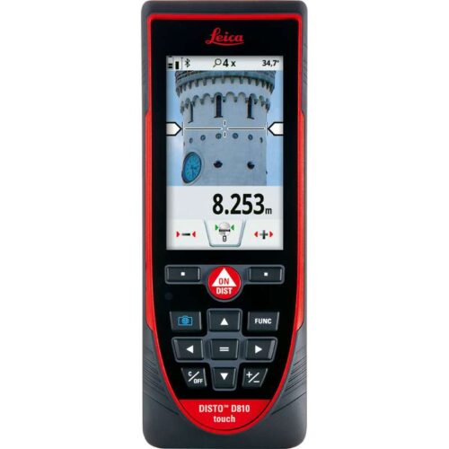 The world’s first ever laser distance meter with a touchscreen, the Leica DISTO™ D810 Touch is here. This all new Disto features an improved, intuitive and faster operation with the revolutionary feature ‘measure with a picture’ which determines distances using its built in hi resolution camera. The camera also allows for pictures to be taken and transferred to a computer easily using a USB system. The ‘Leica DISTO™ sketch’ app, which is available to download for free, improves and completes functionality. Leica Disto Sketch is the ideal interface between a DISTO and smart phone or tablet. They allow sketches or photographs to be created and dimensioned quickly, or the transfer of measurements into a chart. The data can be sent to the office by e-mail. This simplifies and speeds up your workflow.
Features of the Leica DISTO™ D810 touch includes:
- Intuitive Touchscreen
- 4x Zoom Pointfinder
- Hi-Resolution Camera
- Measure with an Camera Picture
- 360° Accurate Tilt Sensor
- Smart Horizontal Mode™
- Height Tracking
- Bluetooth Smart
- Free Leica DISTO™ sketch App
- Battery (Li-Ion)
Supplied with
- Leica DISTO™ D810 touch laser distance meter
- Holster
- Hand loop
- USB charger incl. 4 plugs
-
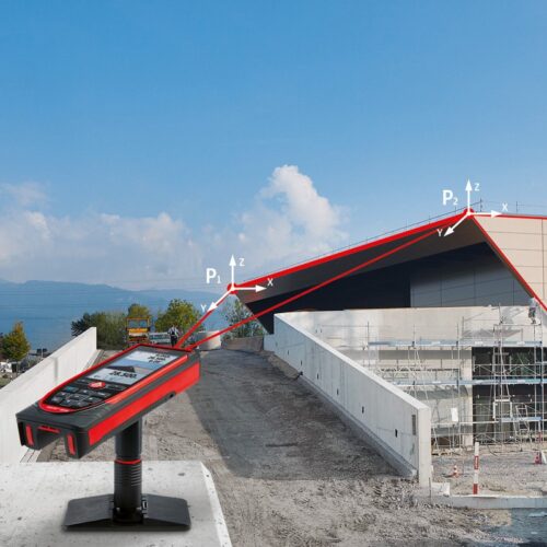
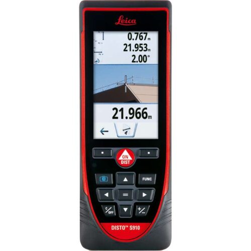
Measure anything, anytime, anywhere.
Measure quickly and accurate distances between two points from a single location with the Leica DISTO™ S910 laser distance meter. Generate effortlessly as-built documentation, determine rooftop dimensions and integrate information into CAD or BIM software for even 3D conceptions. This improved workflows saves valued time and money. All of this at distances of up to 300 meters.Features include:
- Smart Base for P2P Technology
- Pointfinder with 4x zoom for effortless targeting
- X-Range Power Technology for maximum measurement functioning
- 360° tilt sensor
- DXF data capture
- Data transfer in real-time with WLAN
- Bluetooth® Smart
- Free Leica DISTO™ sketch App
Includes:
- Leica DISTO™ S910 laser distance meter
- Smart Base Extension
- Holster
- Hand loop
- USB charger incl. 4 plugs
-
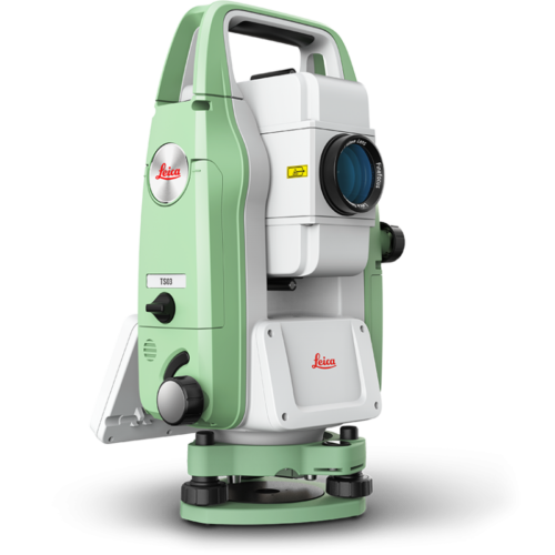
 The Leica FlexLine TS03 high-quality, manual total station is based on a proven product concept that has been revolutionising the world of measurement and survey for nearly 200 years. The Leica TS03 is equipped with a comprehensive application-based software package - Leica FlexField software - that enables most survey and stakeout tasks to be carried out easily and efficiently. The new FlexLine TS03 works reliably and delivers accurate results even in the harshest environments. • Work faster: measure more points per day due to faster measurement and stakeout procedures (endless drives, trigger key, drives on both sides, pinpoint EDM and more), supported by our comprehensive and user-friendly Leica FlexField software. • Use it trouble-free: increase productivity and minimise downtime by relying on instruments that simply work and come with a global service and support network. • Choose products that are built to last: FlexLine operates with the same high level of quality even after years of use under harsh conditions (like mud, dust, blowing rain, extreme heat and cold). • Control your investment: reliability, speed and accuracy ensure a lower investment over the product lifetime and a higher resell value.
 -
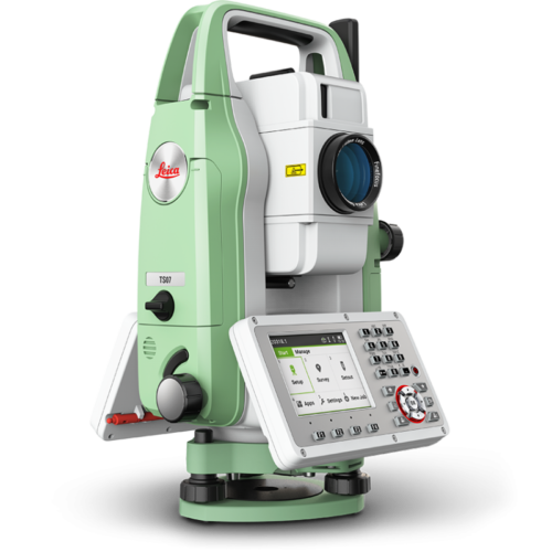
 The Leica FlexLine TS07 high-quality, manual total station is based on a proven product concept that has been revolutionising the world of measurement and survey for nearly 200 years. The Leica TS07 is equipped with a comprehensive application-based software package - Leica FlexField software - that enables most survey and stakeout tasks to be carried out easily and efficiently. The new FlexLine TS07 works reliably and delivers accurate results even in the harshest environments. • Work faster: measure more points per day due to faster measurement and stakeout procedures (endless drives, trigger key, drives on both sides, pinpoint EDM and more), supported by our comprehensive and user-friendly Leica FlexField software. • Use it trouble-free: increase productivity and minimise downtime by relying on instruments that simply work and come with a global service and support network. • Choose products that are built to last: FlexLine operates with the same high level of quality even after years of use under harsh conditions (like mud, dust, blowing rain, extreme heat and cold). • Control your investment: reliability, speed and accuracy ensure a lower investment over the product lifetime and a higher resell value. • Save time with AutoHeight: measure, read and set the instrument height automatically with this revolutionary feature in the FlexLine TS07 (optional). Errors are minimised and the setup process onsite is faster.
 -
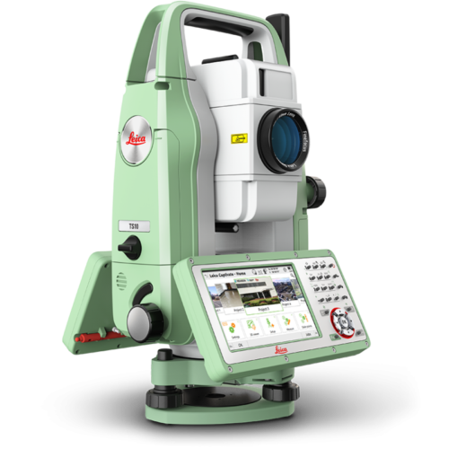
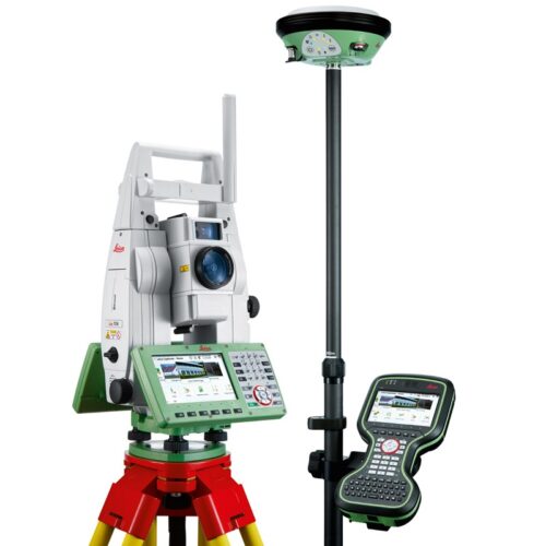
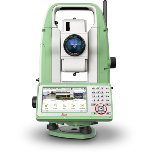 The Leica FlexLine TS10 manual total station combines user-friendly, ergonomic design with high-end reliability under harsh conditions. It enables you to tie into the modern 3D dataflow, including enhanced linework and coding. The TS10 offers mobile data device integration as an option. The larger, highly visible colour- and touchscreen helps you to complete your surveying tasks with the highest speed and accuracy. The new FlexLine generation of manual total stations relies on a proven product concept that has been revolutionising the world of measurement and survey for nearly 200 years. • Work faster: measure more points per day due to faster measurements and stakeout procedures, supported by the revolutionary Leica Captivate field software. The software is made to make your work easier and more enjoyable. • Use it trouble-free: increase productivity and minimise downtime by relying on instruments that simply work and come with a global service and support network. • Choose products that are built to last: even after years of use under harsh conditions (like mud, dust, blowing rain, extreme heat and cold), FlexLine still operates with the same high level of quality. • Control your investment: reliability, speed and accuracy ensure a lower investment over the product lifetime and a higher resell value. • Save time with AutoHeight: this revolutionary feature enables the FlexLine TS10 manual total station to automatically measure, read and set the instrument height. Errors are minimised and the setup process onsite is faster.
 -
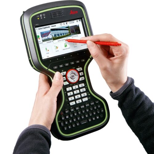
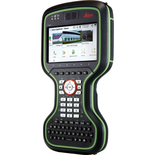
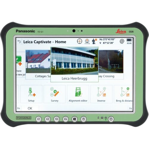
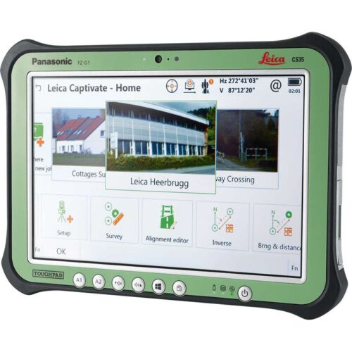
 The Leica TS13 total station provides a fast, reliable and efficient solution tailored to the users needs to measure and layout more points. Equipped with Automatic Target Recognition (ATR) technology and optionally with target lock and SpeedSearch to find and lock on to prisms quickly, it provides accurate measuring to targets. Combined with Leica Captivate field software, the TS13 offers a simple and productive way of coding and line work. The TS13 works with the revolutionary Leica Captivate field software, turning complex data into the most realistic and workable 3D models. It spans industries and applications with little more than a simple swipe, regardless of whether you work with GNSS, total stations or both. A smooth data transfer ensures the project stays on track. Captivate and Leica Infinity office software work in conjunction to join previous survey data and edit projects faster and more efficiently.
 -
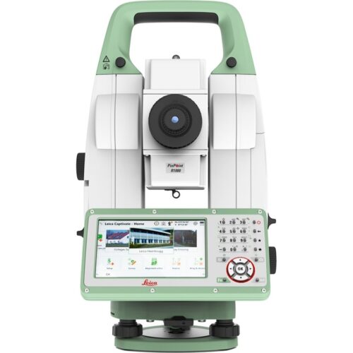
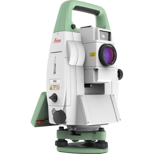 The Leica TS13 total station provides a fast, reliable and efficient solution tailored to the users needs to measure and layout more points. Equipped with Automatic Target Recognition (ATR) technology and optionally with target lock and SpeedSearch to find and lock on to prisms quickly, it provides accurate measuring to targets. Combined with Leica Captivate field software, the TS13 offers a simple and productive way of coding and line work. The TS13 works with the revolutionary Leica Captivate field software, turning complex data into the most realistic and workable 3D models. It spans industries and applications with little more than a simple swipe, regardless of whether you work with GNSS, total stations or both. A smooth data transfer ensures the project stays on track. Captivate and Leica Infinity office software work in conjunction to join previous survey data and edit projects faster and more efficiently. Kit includes:
- TS13 5" R500, total station with ATR
- TOP1, TS13 prism lock option
- TOP2, TS13 robotic option
- GDF311 Tribrach without optical plummet
- GST101 Wooden tripod w/ shoulder strap
- GLS11 reflector pole
- Height meter GHM007 with holder GHT196
- GEB221 Battery int. Li-Ion 7.4V/4400mAh
- GKL311 single Charger Prof 3000
- CS20 3.75G Field Controller
- Leica Captivate Measure & Stakeout CS20
- GEB331 Battery int Li-Ion 11.1V/2800mAh
- MSD1000, SD memory card 1GB
- GVP724 TS Robotic Container
- GRZ4 360° Reflector
- GHT63 Pole clamp for attaching GHT
- GHT66 Holder plate for CS20 controller
- RH17, Bluetooth RadioHandle
- 1 yr TS13+CS20 Basic CCP
-
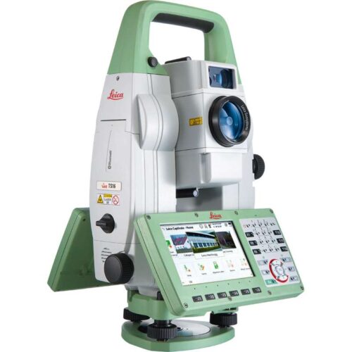
Self-learning in any application
Meet the world’s first self-learning total station. Automatically adjusting to any environmental conditions, the Leica Viva TS16 locks onto your, and only your, target. Regardless of how challenging the task or the amount of distractions in the field, this total station exceeds your expectations. Cover a wide range of applications when this total station sees precisely what you see. Known for the most comprehensive imaging capability available, you can capture exact conditions for any worksite through the self-learning capability of the Leica Viva TS16.Engaging software
The Leica Viva TS16 total station comes with the revolutionary Captivate software, turning complex data into the most realistic and workable 3D models. With easy-to-use apps and familiar touch technology, all forms of measured and design data can be viewed in all dimensions. Leica Captivate spans industries and applications with little more than a simple swipe, regardless of whether you work with GNSS, total stations or both.Infinitely bridging the field to the office
While Leica Captivate captures and models data in the field, Leica Infinity processes the information back in the office. A smooth data transfer ensures the project stays on track. Leica Captivate and Leica Infinity work in conjunction to join previous survey data and edit projects faster and more efficiently.With ATRplus there is only one prism – yours
ATRplus, born from five generations of optimisation, takes known and trusted automation performance to the next level. This superior technology maximises the total station’s ability to remain locked on your target, ignoring other distractions in the field. The Leica Viva TS16 learns the environment, delivers accurate positions even in difficult dynamic applications, and offers the fastest re-lock in case of interrupted line of sight. -

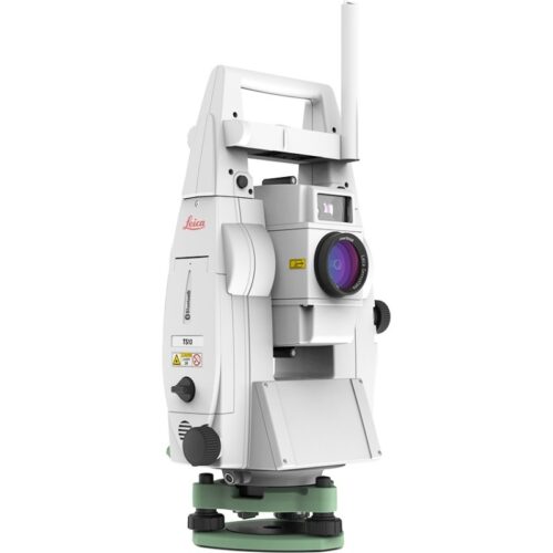
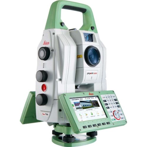 Known for its speed and precision, the Leica Nova TS60 is now a self-learning total station capable of adapting to any site condition. Let this new intuitive technology do the work for you. The only total station in the world that offers dedicated precision in the harshest conditions, the Leica Nova TS60 is designed for the highest accuracy down to the sub-millimetre and sub-second. Experience the meaning of perfected precision, maximum accuracy with the Leica Nova TS60.
Engaging software
The Leica Nova TS60 total station comes with the revolutionary Captivate software, turning complex data into the most realistic and workable 3D models. With easy-to-use apps and familiar touch technology, all forms of measured and design data can be viewed in all dimensions. Leica Captivate spans industries and applications with little more than a simple swipe, regardless of whether you work with GNSS, total stations or both.Infinitely bridging the field to the office
While Leica Captivate captures and models data in the field, Leica Infinity processes the information back in the office. A smooth data transfer ensures the project stays on track. Leica Captivate and Leica Infinity work in conjunction to join previous survey data and edit projects faster and more efficiently.With ATRplus there is only one prism – yours
ATRplus, born from five generations of optimisation, takes known and trusted automation performance to the next level. This superior technology maximises the total station’s ability to remain locked on your target, ignoring other distractions in the field. The Leica Nova TS60 learns the environment, delivers the most accurate positions even in difficult dynamic applications, and offers the fastest re-lock in case of interrupted line of sight. -
Don’t just see data, experience data
Never before has measurement technology provided such an intuitive experience or simple navigation. Incredibly easy software, instruments you trust, help that is only a click away – these combine to form an all-encompassing solution for your most challenging demands. Leica Captivate is the new software for the renowned Leica Nova and Viva measurement instruments. With familiar apps and touch technology, you can now capture and manage complex data with little more than a simple swipe.Dominant performance through seamless integration
The next generation of Leica Viva and Nova measuring instruments become the world’s first self-learning total stations and MultiStation with Leica Captivate. Transforming the Leica Viva GNSS experience, this engaging software joins ultimate GNSS receiver innovation with an industry-first 3D user immersion. Leica Captivate modernises the Leica Nova scanning experience, for the first time merging the overlay of measured points, 3D models and point clouds into a single view.Infinitely bridging the field to the office
While Leica Captivate captures and models data in the field, Leica Infinity processes the information back in the office. A smooth data transfer ensures the project stays on track. Leica Captivate and Leica Infinity work in conjunction to join previous survey data and edit projects faster and more efficiently. -
Don’t just see data, experience data
Never before has measurement technology provided such an intuitive experience or simple navigation. Incredibly easy software, instruments you trust, help that is only a click away – these combine to form an all-encompassing solution for your most challenging demands. Leica Captivate is the new software for the renowned Leica Nova and Viva measurement instruments. With familiar apps and touch technology, you can now capture and manage complex data with little more than a simple swipe.Dominant performance through seamless integration
The next generation of Leica Viva and Nova measuring instruments become the world’s first self-learning total stations and MultiStation with Leica Captivate. Transforming the Leica Viva GNSS experience, this engaging software joins ultimate GNSS receiver innovation with an industry-first 3D user immersion. Leica Captivate modernises the Leica Nova scanning experience, for the first time merging the overlay of measured points, 3D models and point clouds into a single view.Infinitely bridging the field to the office
While Leica Captivate captures and models data in the field, Leica Infinity processes the information back in the office. A smooth data transfer ensures the project stays on track. Leica Captivate and Leica Infinity work in conjunction to join previous survey data and edit projects faster and more efficiently.

-
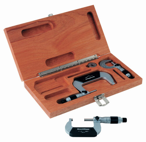 Each Micrometer in the 0-3" Micrometer Sets described on this page includes Brown & Sharpe's convertible fixed/friction thimble with Satin-Chrome finish. Additional features are as specified.
 -
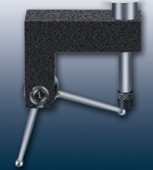 90° Angle Probe
 -
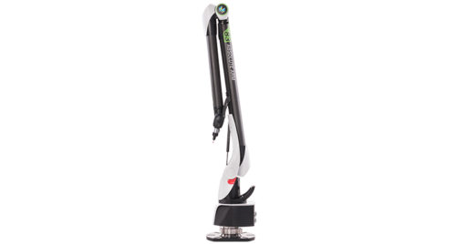
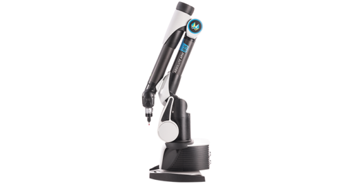
The Portable Measuring Arm Optimised for Probing
A specialised touch measurement tool that also boasts the option for entry-level 3D scanning – the Absolute Arm 6-Axis is one of a kind. Based on patented technology with Absolute Encoders located at every articulation point and designed with ease-of-movement and usage as a focus, this is a portable measuring arm like no other. WiFi and battery options ensure absolute portability while almost 100 probe tip accessories make finding the right tool for any specific touch probe or infrared tube probe application simple. An established repeatable kinematic probe mounting allows for hot-swapping of probe tips with no recalibration, and there’s no need to worry about warm-up or referencing on set-up or repositioning – these are advanced technology solutions that deliver increased productivity and make portable measurement easier than ever. -
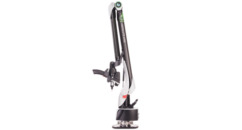
The All-in-One Solution for Portable 3D Measurement
The flagship of the Absolute Arm range, the Absolute Arm 7-Axis delivers tactile probing and laser scanning in a uniquely ergonomic package.It’s the clear choice for high-end portable measurement applications. With usability central to its design, this is an articulating measuring arm that can’t be beaten when it comes to ease of movement and ease of measurement. Built-in versatility comes in the form of a uniquely modular wrist design that features configurable grip shapes and sizes, an on-wrist display that puts control and results in the hands of the user, and a wide range of accessories, from probe tips to laser scanners to complete measurement systems designed for specialised applications. The flagship RS5 Laser Scanner is the key to high-end 3D scanning and digitisation, and can be quickly mounted on the Absolute Arm 7-Axis with no need for recalibration. All this adds up to a far more productive arm that delivers high-accuracy measurement results more quickly and more easily than ever before. -
The World’s Most Accurate Portable Measuring Arm
The Absolute Arm Compact is the ultimate solution for ultra-high-accuracy touch probe measurement of small-to-medium sized parts. Fitting easily on a workshop table or under a CNC machine, the Absolute Arm Compact is the height of portability and usability. It boasts the same definitive features as the flagship Absolute Arm, from Absolute Encoders in every articulation joint that eliminate warm-up and referencing to WiFi and battery operation options that allow easy repositioning and no messy cables across the workshop floor. Built on an integrated base and innovative counterweight balance system, the Absolute Arm Compact is ready to go right out of the box – no warm-up, no waiting, no need to fix it to a work surface – just place it where you need it and start measuring. For quality control that demands fast and extremely accurate measurement, there is simply no better portable measuring arm on the market. -
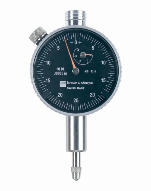
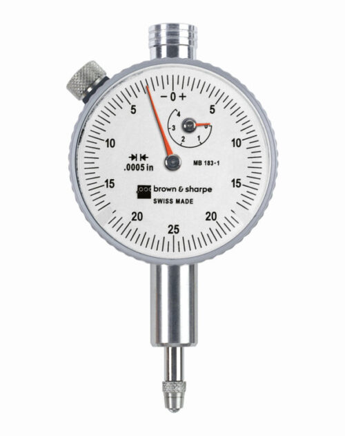 The AGD 1 series dial indicators are supplied with revolution counter, tolerances pointers, central lug back and ball contact tip as standard. Alternative flat and slide back are available as accessories.
 -
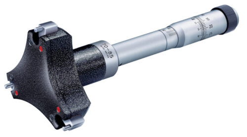 Fitted with a TESA patented capacitive measuring system. Internal micrometers with 3-line contact. All TESA ALESOMETER are specially suited for through and blind bores, as well as short centring shoulders, except for the models covering the application range from .236 in to .397 in / 6 mm to 10 mm.
 -
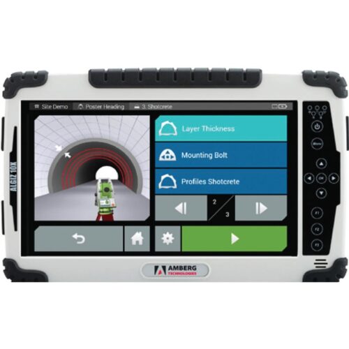
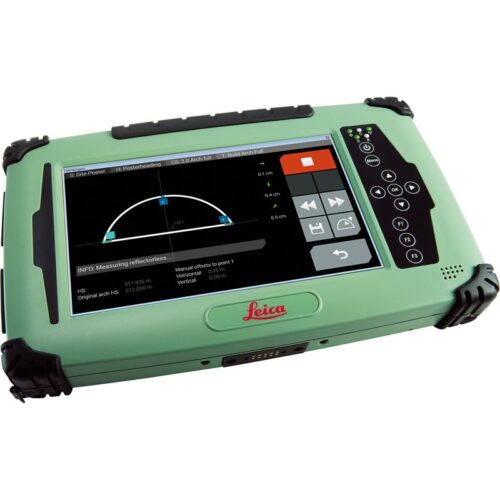
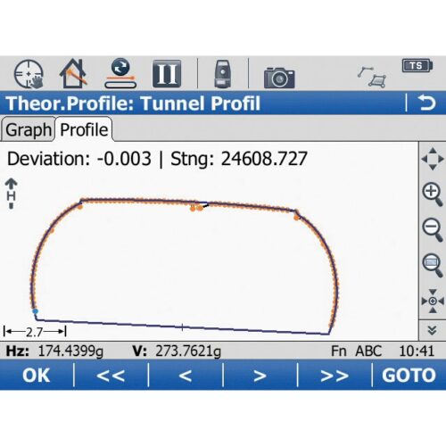
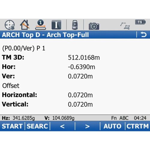
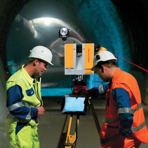
 Today, the recording of profile measurement data is integrated directly into the process of tunnel construction as standard procedure for all tunneling projects. The main requirements for profile measurement include easy operation of the instruments by the surveyor or the tunnel team and simple, relevant analysis functions. After the profile data has been recorded in the tunnel, they need to be managed and refined. Amberg Control transforms your surveying data into simple, meaningful and relevant reports – regardless of the instrument used for data collection.
 -
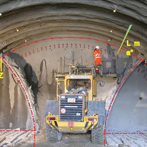
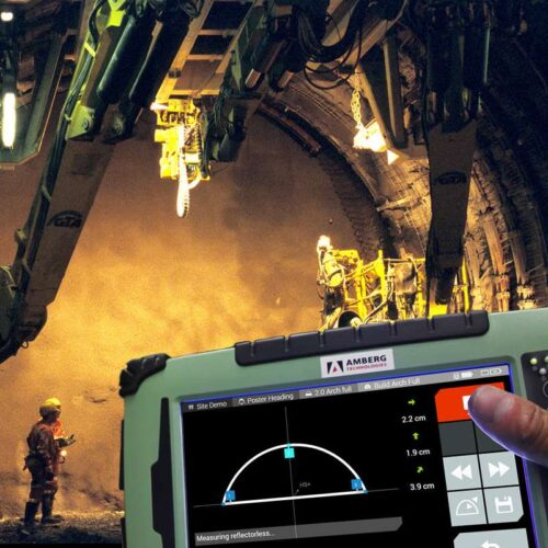 Optimise tunnelling performance with Navigator Increasingly complex project requirements and enormous investments contrast with a continuous rise in price and deadline pressures. Efficient, cost-effective surveying solutions are needed, without placing precision and safety at risk. Equipment needs to be tailored optimally to a specific project and be usable by the tunnel crew on site. With Amberg Navigator, you can choose which tasks you need for your heading guidance, excavation control and surveying of the inner lining. From start to finish of the tunnelling process Amberg Navigator can control every aspect. Touch and build Tunnel heading guidance and control has never been as easy as with Amberg Navigator. Amberg Navigator consists of the mobile Amberg Navigator tablet for the application in the tunnel and the Amberg Tunnel software for project definition in the office. The tablet is operated by the tunnelling crew on site via the touchscreen. The tasks arranged in the Amberg Navigator tablet software based on the project-specific applications provide fully automatic control of the total station according to the tasks selected.
 -
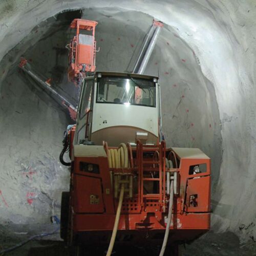
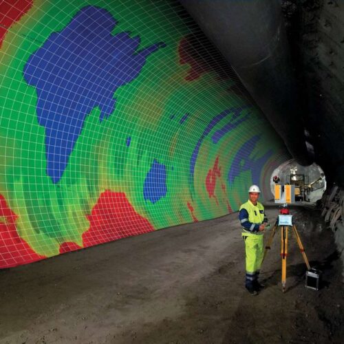
 Amberg ProScan plus is the systematic approach to profile accuracy: precise geometric data, continuous comparison of design versus actual profiles, and reliable quantity calculations. Amberg ProScan plus is the ideal cost saving solution for excavation monitoring, geological overbreak calculation, nondestructive concrete layer thickness control, determining as-built tunnel axis in TBM tunnels, complete information for quantity surveying and project accounting, base data for refurbishment projects, and comprehensive as-built construction work documentation.
 -
 The configuration consists of
- Premium hardware GRP 3000
- Application specific software Clearance Basic
- Robust and guaranteed precision thanks to GRP Fidelity
- First-class application support
- Central database for input, visualisation and management of clearance envelopes, clearance models, track project data including route data chronology, control points and measuring epochs.
- Flexible and user friendly clearance envelope editor.
- Provision of all clearance specifications for subsequent surveying tasks and evaluations.
- Profile measurements in 2D clearance mode or 3D coordinate mode with combined capturing of all relevant track geometry data (stationing, gauge, superelevation, 3D track coordinates (with TPS, GPS only)).
- Profile data collection:
- - Either with manual object point targeting.
- - Or automatic profile measurement with definable point density on the object surface.
- Display of profile distances between measured object and selected theoretical clearance envelope in real-time directly on site.
- Complete surveyed data management including automatic incorporation of subsequent re-measurements.
- Fully automatic evaluation by comparing clearance surveys with a predefined clearance model for given section – either relative to the current track position or (for 3D data) in terms of a predefined, theoretical track position.
- Comprehensive, automatic reporting.
- - Profile plot including clearance distances.
- - Coordinate list with additional gauging information.
- Established interfaces to third party clearance and design applications like DXF, ASCII, SC0 (ClearRoute), LUE (Lira).
-
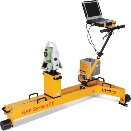
 The configuration consists of
- Premium hardware GRP 5000
- Application specific software Clearance Plus
- Robust and guaranteed precision thanks to GRP Fidelity
- First-class application support
-
 The configuration consists of
- Premium hardware GRP 5000
- Application specific software Clearance Plus
- Robust and guaranteed precision thanks to GRP Fidelity
- First-class application support
-
 Complete railway infrastructure data in no time – simple and high performant The new way of railway infrastructure scanning
- Well-tried GRP 5000 system enhanced with IMU technology
- Combined survey of relative and absolute track geometry
- Comprehensive scan data for clearance analysis and design purposes
- Highly accurate 3D point cloud of complete infrastructure
- Unrivalled survey performance up to 4,000 m/h
- No total station or GNSS signal required for absolute data
- Measuring trolley consisting of precision sensors for gauge, superelevation and distance as well as ruggedized notebook
- Laserscanner Amberg Profiler 6012 for acquisition of complete infrastructure
- AMU 1030 (Amberg Measuring Unit) for unrivalled kinematic measurement precision
- Modular system upgrading possibilities
- High performance for short and long track sections – up to 4,000 m/h
- Absolute 3D control points as transformation references
- Switching on / off control points for processing depending on quality
- Unlimited use during day and night – no line of sight requirements
- Pure relative survey of track geometry and objects around track
- Stationing plates as references
- Measurement and calculation of track parameters like horizontal / vertical versines, curvature / radius, gauge, superelevation and twist
- Usage of these parameters e.g. for dynamic clearance analysis
-

Track surveying: faster, more efficient and more accurate
New measuring sensor: AMU 1030 (Amberg Measuring Unit)- Based on IMU technology (Inertial Measurement Unit)
- Integrated microcomputer
- Surveying of track alignment with AMU instead of a total station
-
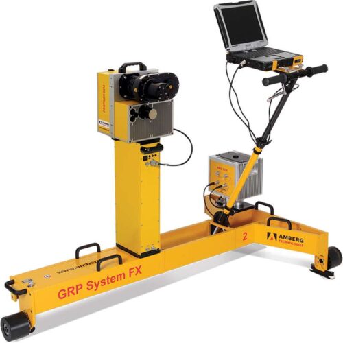
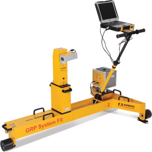
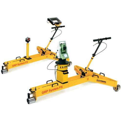
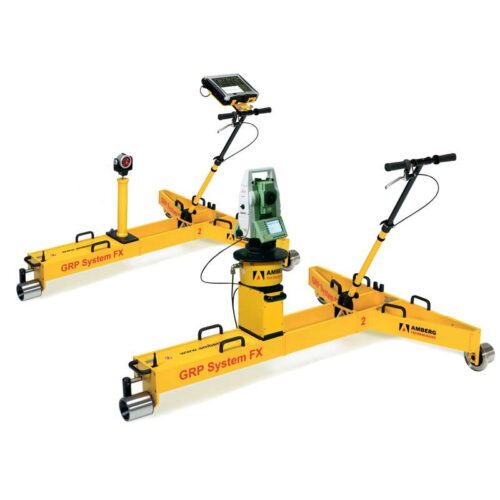
 The configuration consists of
- Premium hardware GRP 1000
- Application specific software Slab Track Plus
- Robust and guaranteed precision thanks to GRP Fidelity
- First-class application support
-


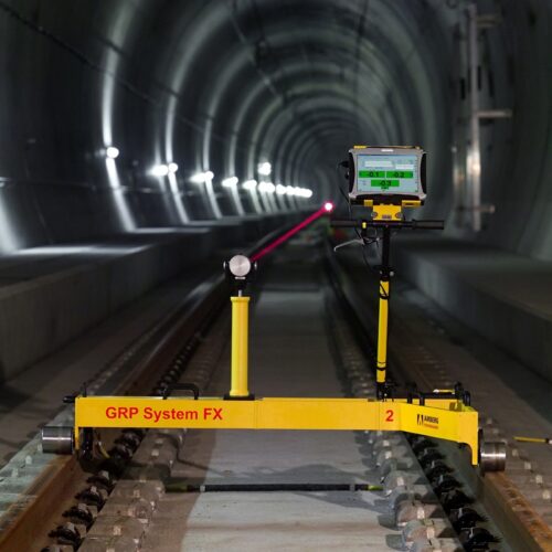
Control of the Slab Track at high speed
Revolution of a measuring principle- Trusted VMS work procedure (long-chord method) – with only one measurement trolley
- Combined survey of relative and absolute track geometry in one run
- Absolute track accuracy up to 1 mm
- Unrivalled survey performance up to 4000 m/h
- No geodetic skills for operator required
- Up to 90 % cost savings compared to traditional methods
- Measuring trolley consisting of precision sensors for gauge, superelevation and distance and ruggedized notebook
- AMU 1030 (Amberg Measuring Unit) for unrivalled kinematic measurement precision
- Two control point (CP) measuring devices of choice
- Tachymeter (IMS 1000): single and multi CP mode
- Profiler 110 FX (IMS 3000): single CP mode
- Modular system upgrading possibilities
- Easy handling, simple transportation
- LED-lighting for secure work at night
- Robust hardware design for hard environment
- High performance for long track sections
- First choice for measurements during short track closures
- Measuring performance up to 4000 m/h, typically 2500 m/h
- Distance between CP measurements up to 500 m
- Fully automatic relative control point measurement with IMS 1000
- No loss of accuracy due to refraction
- Multi control point mode
- For demanding project accuracies
- Tachymeter setup with multiple control points ensures highest accuracy and reliability
- Complete setup control out of Amberg Rail software
- Measuring performance up to 1500 m/h, typically 1000 m/h
- Distance between Tachymeter resections up to 500 m
- Increased efficiency without Tachymeter leveling
- Minimization of potential control point errors
-
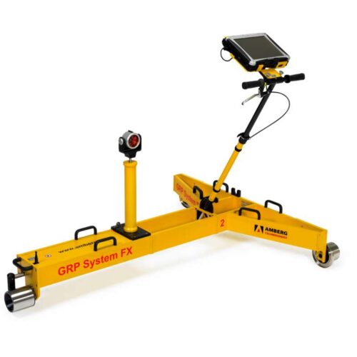
 The configuration consists of
- Premium hardware GRP 1000
- High-performance software Amberg Survey Basic
- Optional: Amberg Track Geometry Record (TGR)
- Robust and guaranteed precision thanks to GRP Fidelity
- First-class customer support
-
 As-built track survey at its best. Extension of a revolutionary measuring principle
- Long-chord method with only one measurement trolley for as-built survey
- Combined survey of relative and absolute track geometry
- Unrivalled survey performance up to 5000 m/h
- Repeat accuracy ± 1 mm
- Up to 90% cost savings compared to traditional methods
- Unlimited use during day and night, rain and bright sunshine - no line of sight requirements
- Measurement of objects close to track
- Measuring trolley consisting of precision sensors for gauge, superelevation and distance and ruggedized notebook
- AMU 1030 (Amberg Measuring Unit) for unrivalled kinematic measurement precision
- Two different control point measuring devices:
- Total station (IMS 1000, fully automatic measurement)
- Profiler 110 FX (IMS 3000)
- Modular system upgrading possibilities
- Measuring performance up to 4000 m/h, typically 2500 m/h
- Absolute 3D control points given in global coordinate grid and used as transformation references
- Distance between CP measurements up to 500 m
- Fully compatible with other geodetic 3D survey data
- Measuring performance up to 4000 m/h, typically 2500 m/h
- Setup and survey of control points during initial track survey
- Track data available in local 3D coordinate grid
- Determination of local 3D coordinates for established control points
- Results can be used for local track design and track works as well as monitoring purposes
- Measuring performance up to 5000 m/h, typically 3500 m/h
- Stationing plates as references
- Measurement and calculation of track parameters horizontal versines (variable chord length), vertical versines (variable chord length), gauge, superelevation and twist
- Presentation and analysis of track data with sophisticated
- Track Geometry Record (TGR)
-
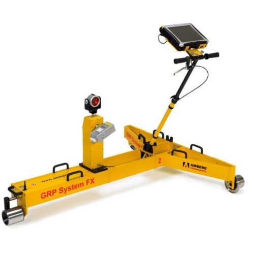
 The configuration consists of
- Premium hardware GRP 1000
- Application specific software Tamping Plus
- Robust and guaranteed precision thanks to GRP Fidelity
- First-class application support
-
 The configuration consists of
- Premium hardware GRP 3000
- Application specific software Tamping Plus
- Robust and guaranteed precision thanks to GRP Fidelity
- First-class application support
-

The fastest track survey systems for precise track works
Revolution of a measuring principle- Trusted VMS work procedure (long-chord method) – with only one measurement trolley
- Combined survey of relative and absolute track geometry in one run
- Absolute track accuracy up to 1 mm
- Unrivalled survey performance up to 4000 m/h
- No geodetic skills for operator required
- Various export formats and safe transfer of correction data for tamping machines
- Up to 90 % cost savings compared to traditional methods
- Measuring trolley consisting of precision sensors for gauge, superelevation and distance and ruggedized notebook
- AMU 1030 (Amberg Measuring Unit) for unrivalled kinematic measurement precision
- Two control point (CP) measuring devices of choice:
- Tachymeter (IMS 1000): single and multi CP mode
- Profiler 110 FX (IMS 3000): single CP mode
- Modular system upgrading possibilities
- Easy handling, simple transportation
- LED-lighting for secure work at night
- Robust hardware design for hard environment
- High performance for long track sections
- First choice for measurements during short track closures
- Measuring performance up to 4000 m/h, typically 2500 m/h
- Distance between CP measurements up to 500 m
- Fully automatic relative control point measurement with IMS 1000
- No loss of accuracy due to refraction
- No line of sight required
- For demanding project accuracies
- Tachymeter setup with multiple control points ensures highest accuracy and reliability
- Complete setup control out of Amberg Rail software
- Measuring performance up to 1500 m/h, typically 1000 m/h
- Distance between Tachymeter resections up to 500 m
- Increased efficiency without Tachymeter leveling
- Minimization of potential control point errors
-

The flexible tamping survey solution for rail track works.
Easy to use – fully controlled – highly efficient. From preparation through to evaluation -
The long-chord track survey system for precise track works
Proven measuring principle – optimized for track works- Long chord method
- Combined survey of inner track geometry and absolute position in one run
- Absolute track accuracy 1 mm
- Correction data in real-time
- Fully automatic control point measurement
- Best survey performance
- More than 80 % cost savings compared to traditional methods
- Flexible system operation: twin-trolley mode or tripod mode
- Modular system upgrading
- Safe digital data handling – from measurement to final transfer of correction data
- Easy handling, simple transportation
- Flexible measuring mode
- No geodetic skills required
- LED-lighting for secure work at night
- 1st choice for measurements during track closures
- Measuring performance up to 2500 m/h
- Length of reference chord of up to 250 m
- Measuring system GRP 1000 consisting of precision sensors for gauge, superelevation and distance, prism column and ruggedized notebook
- Measuring system GRP TSC+ with precision sensors and tachymeter on automatic self-levelling tribrach
- Extendable to two independent single trolley systems (for alternate operation in tripod mode)
- Ideal for shorter track sections, e.g. turnouts, multi-track sections and projects with limited track access
- Length of reference chord of up to 400 m Measuring system GRP 1000
- Tachymeter on tripod (optional with automatic self-levelling tribrach)
- Flex-Stop-Function for immediate measurement interruption and track release
- Upgradable with second measuring trolley at any time
-

The long-chord track survey system for demanding track works
Innovation of a proven principle for track works- Long chord method
- Combined survey of track and lateral distance offsets in one run
- Absolute accuracy 3 mm
- Greatest operational flexibility – thanks to twin-trolley mode and tripod mode option
- Integrated fixed-point measuring device
- Cost savings of 70 % and more compared to manual / optical chord methods
- Safe digital data handling – from initial data input to final transfer of correction data
- Easy handling and flexible transportation
- 1st Choice for measurements during track closures
- Measuring performance of up to 2300 m/h
- Length of reference chord of up to 250 m
- Measuring system GRP 3000 consisting of precision sensors for gauge, superelevation and distance, Profiler 110 with prism and ruggedized notebook
- Measuring system GRP TSC with automatic tripod for quick and easy self-levelling of tachymeter
- LED lightening bar assuring safe work during night
- User friendly handling specially designed for track workers
- Ideal for short track sections, e.g. turnouts, multi-track sections and projects with limited track access
- Length of reference chord of up to 400 m
- Measuring system GRP 3000
- Tachymeter on tripod (with automatic self-levelling tribrach)
- Flexible measuring mode – as twin-trolley mode – complemented by Flex-Stop functionality
- Immediate measurement stop for rapid track clearance on demand – without impact on performance
- Modular system design allows upgrading at any time e.g. 2nd trolley and other survey applications
-

Proven measuring principle – optimized for track works
- Long chord method
- Combined survey of inner track geometry and absolute position in one run
- Absolute track accuracy 1 mm
- Correction data in real-time
- Fully automatic control point measurement
- Best survey performance
- More than 80 % cost savings compared to traditional methods
-
Innovation of a proven principle for track works
- Long chord method
- Combined survey of track and lateral distance offsets in one run
- Absolute accuracy 3 mm
- Greatest operational flexibility – thanks to twin-trolley mode and tripod mode option
- Integrated fixed-point measuring device
- Cost savings of 70 % and more compared to manual / optical chord methods
- Safe digital data handling – from initial data input to final transfer of correction data
- Easy handling and flexible transportation
-
 The Amberg SetOut offers exceptional functionality, flexibility and productivity to tunnel surveying. With Amberg SetOut and a mobile tripod, set out routines in relation to the tunnel axis are automised. Suitable for daily surveying works or special challenges, all project data are permanently available on the total station through a single software solution which offers a full range of setting out in conventional tunnel construction.
 -
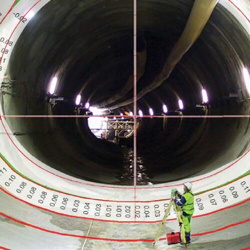
 Amberg Tunnel Scan can undertake complete profile checks and non-destructive layer thickness measurements together with surface quality checks to produce scaled image documentation and detailed dimensioning for optimised logistics and billing. It will record the geometry and image of the entire tunnel structure during each construction phase, calculate detailed excavation quantities, check the conformity of undulation of the tunnel surface layer and process scanning data from other scanner types through a standard PTS data interface. This is a mobile, autonomous and modular system designed for optimal integration into the construction process.
 -
 Amberg Tunnel Solutions can be supplied with TMS Setout, TMS Profile, and TMS Tunnelscan and offers multifunctional and flexible operation with effortless transfer of complex planning data. This is an integrated system which brings together transfer of complex planning data, short preparation times and optimal support for all tunnel construction processes. Surveying solutions with powerful modules for:
- Tunnel setting out
- Profile measurement
- Tunnel scanning
- Structure dimensioning